Prača (river)
| Prača | |
|---|---|
 | |
| Country | Bosnia and Herzegovina |
| Physical characteristics | |
| River mouth |
Drina 43°41′29″N 19°05′05″E / 43.69139°N 19.08472°ECoordinates: 43°41′29″N 19°05′05″E / 43.69139°N 19.08472°E |
| Length | 55 km2 (21 sq mi) [1] |
| Basin features | |
| Progression | Drina→ Sava→ Danube→ Black Sea |
| Basin size | 1,019 km2 (393 sq mi) [1] |
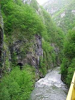
The Prača (Serbian Cyrillic: Прача) is a left tributary of the Drina in eastern Bosnia and Herzegovina. It source is in Pale, Bosnia and Herzegovina at an altitude of 1540 m. After 55 km it flows into the Drina in Ustiprača.
References
- 1 2 "Sava River Basin Analysis Report" (PDF, 9.98 MB). International Sava River Basin Commission. September 2009. p. 14. Retrieved 2018-05-18.
This article is issued from
Wikipedia.
The text is licensed under Creative Commons - Attribution - Sharealike.
Additional terms may apply for the media files.