Duboka (Vrbanja)
| Duboka Дубoкa | |
|---|---|
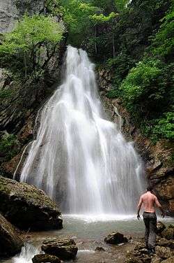 Waterfall "Skakavac" | |
| Native name | Duboka |
| Country | Bosnia and Herzegovina |
| Physical characteristics | |
| Main source |
Međugorje Mountain 1,030 m (3,380 ft) |
| River mouth |
Vrbanja 44°31′05″N 17°29′44″E / 44.5181°N 17.4955°ECoordinates: 44°31′05″N 17°29′44″E / 44.5181°N 17.4955°E |
| Length | 8 km (5.0 mi) |
| Basin features | |
| Progression | Vrbanja→ Vrbas→ Sava→ Danube→ Black Sea |
The Duboka (Дубoкa) river (Deep river) is left tributary of the Vrbanja river in (Bosnia). It rises under Međugorje Mountain (1,116 m), and Bojići village (Skender Vakuf), on around 1,030 meters above sea level. It grows strong after large Gladno vrelo (Hungry spring). To its mouth Duboka receives the abundance of streams, brooks and coastal streams (on both of river banks).
Cord area around Međugorje (Ravna gora, Ravna planina, Paljike, Paunica and Borak) is extraordinary rich with drinking water streams flowing all over the area.[1][2][3][4]
Between Mekote and Gradine localities, Duboka enters into deep canyon, from which originated its name, as well as the village through which flows. Its length is around 8 km. At 1960' on this river it were 5 water-mills.[5] Depth of the canyon on its just beginning is on the river level on 941 meters above sea level, and below Ježica Mountain (1276 m), i.e. under the cliff so called Stijena (Rock, 1,200 m) canyon's depth over 560 metres. The mouth to Vrbanja river is on its large curve between Grabovička rijeka and Tovarnica highland, on 430 meters above sea level.
During the War in Bosnia, in the canyon of Duboka, around 200 Bosniaks were captivated and transported to Elementary Scholl in Grabovica (mouth place of Grabovička rijeka) and become to be missing persons till today.[6][7][8][9][10][11][12]
References
- ↑ Spahić M. et al. (2000): Bosna i Hercegovina (1:250.000). Izdavačko preduzeće „Sejtarija“, Sarajevo.
- ↑ Mučibabić B., Ed. (1998): Geografski atlas Bosne i Hercegovine. Geodetski zavod BiH, Sarajevo.
- ↑ https://maps.google.com/
- ↑
- ↑ Vojnogeografski institut, Ed. (1955): Travnik (List karte 1:100.000, Izohipse na 20 m). Vojnogeografski institut, Beograd.
- ↑ Fena, Agencija (2013): Obilježavanje 21. godišnjice stradanja Bošnjaka u Kotor-Varoši – Još se traži 277 osoba. Avaz, 03. 11. 2013.
- ↑ "MLADIĆEVA OPTUŽNICA OSTALA NETAKNUTA | SENSE Agency | Vest". sense-agency.com. Retrieved 2014-08-05.
- ↑
- ↑ "RATKO MLADIĆ PREBACUJE ODGOVORNOST NA SRPSKE CIVILE | SENSE Agency | Vest". sense-agency.com. Retrieved 2014-08-05.
- ↑ "IT-99-36 Brđanin, Date: 2003 05 27, Hearing Type: IT". ictytranscripts.org. Retrieved 2014-08-05.
- ↑ "PRVI SVEDOK NA SUĐENJU MLADIĆA". forum.krstarica.com. Retrieved 2014-08-05.
- ↑ "Svedok protiv Mladića: Pogubljeno oko 150 muslimana u Grabovici | Vesti Krstarice". vesti.krstarica.com. Retrieved 2014-08-05.