Boračko jezero
| Boračko jezero | |
|---|---|
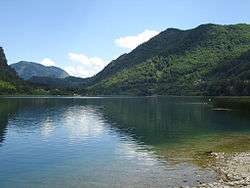 Boračko jezero at Borci | |
 Boračko jezero | |
| Location | Bosnia and Herzegovina |
| Coordinates | 43°33′09″N 18°01′52″E / 43.552429°N 18.031172°ECoordinates: 43°33′09″N 18°01′52″E / 43.552429°N 18.031172°E |
| Primary inflows | Borački potok |
| Primary outflows |
Šištica River (tributary of Neretva river) |
| Catchment area | 2.600 m2 (27.99 sq ft) |
| Basin countries |
|
| Max. length | 786 m (0.488 mi) |
| Max. width | 402 m (1,319 ft) |
| Surface area | 0.26 km2 (0.10 sq mi) |
| Average depth | 1 m (3.3 ft) |
| Max. depth | 17 m (56 ft) |
| Water volume | 2.500 m3 (88.3 cu ft) |
| Surface elevation | 397 m (1,302 ft) |
| Islands | None |
| Settlements | Borci |
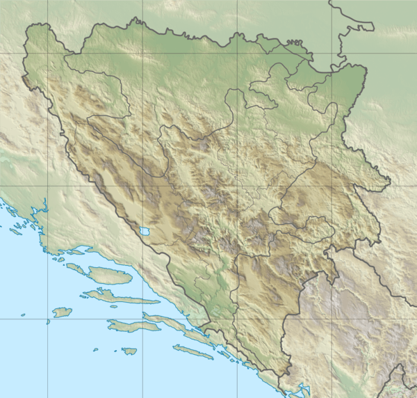
Boračko jezero is glacial lake, situated in Konjic Municipality, Bosnia and Herzegovina.[1][2][3]
It lies at the northeastern foot of the mountain Prenj, at an altitude 397 m. From the west it is surrounded by steep forested mountain slopes of the Crna Gora (Monte Negro, 1343 m), and from the east Tranjine (1055 m). The Lake basin was created in the Boračka draga, during the expensive process of glacial erosion.
Boračko jezero has an elliptical shape. Its length is 786, and 402 m wide. Its surface area is 0.26 square kilometers. Length of lake shore is 2.4 km. The lake is the deepest in the southeastern narrow part of about 17 m, and contains about 2.5 mil.m³ water, which is due to the greenish color is transparent and up to 8.3 m. The water is warmest in August (about 25 °C), the coldest in February (0 °C).
See also
References
- ↑ http://www.kartabih.com/
- ↑ Vojnogeografski institut, Ed. (1955): Konjic (List karte 1:100.000, Izohipse na 20 m). Vojnogeografski institut, Beograd.
- ↑ Mučibabić B., ed. (1998). Geografski atlas Bosne i Hercegovine. Sarajevo: Geodetski zavod BiH. ISBN 9958-766-00-0.
Ehternal links
| Wikimedia Commons has media related to Boračko jezero. |