Mudgeeraba, Queensland
| Mudgeeraba Queensland | |||||||||||||||
|---|---|---|---|---|---|---|---|---|---|---|---|---|---|---|---|
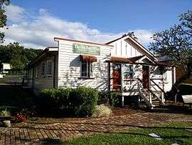 Old Post Office, 2015 | |||||||||||||||
| Population | 13,624 (2016 census)[1] | ||||||||||||||
| Postcode(s) | 4213 | ||||||||||||||
| LGA(s) | City of Gold Coast | ||||||||||||||
| State electorate(s) | Mudgeeraba | ||||||||||||||
| Federal Division(s) | McPherson, Wright | ||||||||||||||
| |||||||||||||||
Mudgeeraba is a suburb in the Gold Coast hinterland in Queensland, Australia. At the 2011 Australian Census, the suburb recorded a population of 13,204.[2]
Mudgeeraba's essential character remains one of a nineteenth-century village, and contains important evidence of its earlier form and building. Most older houses are situated on large blocks of 0.5 acres (2,000 m2) to 2 acres (8,100 m2), alongside much larger farming properties situated in the area.
It is thought that the name of the town was derived from an Indigenous Australian expression meaning, "place of infant's excrement", "place where someone told lies" or "place of sticky soil".[3] Another theory is that the name means "low-lying ground".[4][5]
History
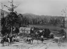
Mudgeeraba is remnant of the type of township that characterises the rural hinterland of the Gold Coast. Subdivision of land was conventional and buildings were traditionally rural or rural commercial. The Schmidt Farmhouse is typical of farms of that period in the district (the farmhouse is now in the adjacent suburb of Worongary).[6]
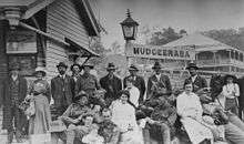
Mudgeeraba, like other areas in the region, was an early centre for farming, timber getting and cattle grazing by the mid-1870s.[7] It rose to some prominence with the coming of the railway from Brisbane to Tweed Heads in 1903.[8] The station of the South Coast railway line was located near the present-day motorway entrance.[9] In 1890, the Queensland State Government indicated that the railway station would be positioned as close to the township, located on Coach Road, as possible.[10] Following the decision was made to position the railway station at some distance to the town, early residents acquired land nearby. Once the railway line was in operation the centre of the town was relocated to its present position.[11] The railway was closed in 1961. The modern day Pacific Motorway largely follows the route of the former railway. The new Gold Coast railway opened on a different alignment from Brisbane to neighbouring Robina in 1998. Robina station is about 1.8 km further than the old Mudgeeraba railway station.
In the early 1930s during the Great Depression, the Upper Mudgeeraba Creek banks were the location of unemployment relief camps set up under the Income (Unemployment Relief) Tax Acts, 1930. The creek water helped sustain vegetable gardens for the residents, housed in timber and corrugated iron huts.[12] One aspect of the relief scheme put in place by the Queensland Government was to establish small banana plantations. In Upper Mudgeeraba, 300 acres divided into 50 blocks were made available to successful applicants to farm.[13][14][15]
Mudgeeraba is home to the Mudgeeraba Water Treatment Plant and a pump and pipeline runs from the Little Nerang Dam to the Water Treatment Plant operated by SEQWater. An above-ground concrete pipeline runs from the WTP through Mudgeeraba to Tugun and Molendinar.[16]
Mudgeeraba is also home to the Mudgeeraba Holiday Village which has received national media attention.[17]
The Gold Coast City Council opened a public library at the Old Post Office Heritage Centre in Railway Street in 2004. However it did not attract a lot of patronage and it was decided to merge it into the Robina Library with the Mudgeeraba branch closing on 25 January 2017. [18] The Gold Coast City Council operates a fortnightly mobile library service which visits Railway Street beside Mudgeeraba Pool.[19]
Geography
Mudgeeraba Creek is the major creek of a catchment area in the southern region of the Gold Coast. It is part of the larger catchment area of Nerang River. Bonogin and Wyangan Creeks are tributaries of Mudgeeraba Creek.
Since 2005, under the Beaches to Bushland restoration program, Gold Coast City, with the help of Austinville Landcare Group, have worked on restoration of areas of upper Mudgeeraba Creek.[20]
Heritage Listings
Mudgeeraba has a number of local heritage-listed sites,[21] including:
- Mudgeeraba Old Post Office (formerly Nerang Shire Council Chambers)
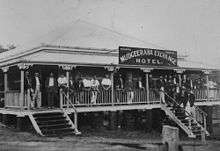
- Wallaby Hotel (formerly Exchange Hotel)
- Mudgeeraba State School
- Hardy's House
- Hardy's Bridge
Notable people
- d'Arcy Doyle, artist
- Darius Boyd, rugby league player for the Brisbane Broncos
- Matthew Saunoa, 2006 New Zealand Idol champion
Schools
Mudgeeraba State School has about 900 students enrolled.[22] Somerset College was opened in January 1983.[23] Other schools in the area include Clover Hill State School, Mudgeeraba Creek State School and Mudgeeraba Special School.
Facilities
The Gold Coast City Council provides the Old Post Office (formerly the Mudgeeraba Library) to community groups and activities for both adults and children involving computing, technology, robotics etc.[24]
Demographics
In the 2011 census, Mudgeeraba recorded a population of 13,204 people, 51.3% female and 48.7% male.[2] The median age of the Mudgeeraba population was 36 years, 1 year below the national median of 37. 69% of people living in Mudgeeraba were born in Australia. The other top responses for country of birth were New Zealand 8.5%, England 6.1%, South Africa 1.7%, Scotland 0.7%, Germany 0.7%. 88.7% of people spoke only English at home; the next most common languages were 0.7% Japanese, 0.6% German, 0.6% Mandarin, 0.4% Cantonese, 0.4% Spanish.[2]
Sport and recreation
A number of sporting teams represent the area, including the Mudgeeraba Redbacks, the local rugby league club who play home games at Firth Park, the Hinterland District Netball Association who run a large competition on Saturday mornings for players 5yrs to 17yrs and Monday nights for 13yrs to opens at Firth Park, Somerset Drive, Mudgeeraba, the Mudgeeraba Lawn Bowls Club situated just behind the Rugby Club, and the Mudgeeraba Soccer Club. Mudgeeraba Spartans Junior AFL Club plays their home games at Somerset College.
References
- ↑ Australian Bureau of Statistics (27 June 2017). "Mudgeeraba (State Suburb)". 2016 Census QuickStats. Retrieved 6 February 2018.

- 1 2 3 Australian Bureau of Statistics (31 October 2012). "Mudgeeraba (State Suburb)". 2011 Census QuickStats. Retrieved 14 October 2013.
- ↑ "Mudgeeraba history". www.goldcoast.qld.gov.au. Gold Coast City Council. Retrieved 13 June 2017.
- ↑ "SKETCHER". The Queenslander. National Library of Australia. 11 April 1914. p. 8. Retrieved 18 September 2012.
- ↑ "ANSWERS". The Brisbane Courier. National Library of Australia. 12 December 1931. p. 14. Retrieved 18 September 2012.
- ↑ "Schmidt Farmhouse & Outbuildings (former) (entry 601889)". Queensland Heritage Register. Queensland Heritage Council. Retrieved 16 November 2014.
- ↑ "THE NERANG AND SOUTHWARDS". The Brisbane Courier. XXVII, (4, 901). Queensland, Australia. 14 June 1873. p. 5. Retrieved 15 May 2016 – via National Library of Australia.
- ↑ "OPENING NEW LINES". The Brisbane Courier. LX, (14, 244). Queensland, Australia. 8 September 1903. p. 7. Retrieved 15 May 2016 – via National Library of Australia.
- ↑ "Mudgeeraba history". City of Gold Coast Council. Retrieved 15 November 2014.
- ↑ "Southern Railway Extension". The Queenslander. XXXVII, (755). Queensland, Australia. 22 March 1890. p. 535. Retrieved 15 May 2016 – via National Library of Australia.
- ↑ "MUDGEERABA". South Coast Bulletin. 8, (399). Queensland, Australia. 17 January 1936. p. 4. Retrieved 15 May 2016 – via National Library of Australia.
- ↑ "Mudgeeraba and Currumbin Creeks unemployment relief camps, 1931". Department of Labour and Industry. Retrieved 30 November 2013.
- ↑ "MUDGEERABA BANANA SCHEME". The Nambucca and Bellinger News. 29, (1446). New South Wales, Australia. 12 January 1934. p. 2. Retrieved 15 May 2016 – via National Library of Australia.
- ↑ "MUDGEERABA". South Coast Bulletin. 5, (246). Queensland, Australia. 1 September 1933. p. 3. Retrieved 15 May 2016 – via National Library of Australia.
- ↑ "THE BANANA SETTLEMENT". South Coast Bulletin. 5, (262). Queensland, Australia. 22 December 1933. p. 10. Retrieved 15 May 2016 – via National Library of Australia.
- ↑ "South East Queensland Water Projects" (PDF). Queensland Government. Retrieved 13 June 2017.
- ↑ Elder, Jessica (9 April 2016). "Mudgeeraba Holiday Village living conditions so poor children are removed". Gold Coast Bulletin. Retrieved 13 June 2017.
- ↑ Jackson, Cam (22 November 2016). "Mudgeeraba Library to close in January". Gold Coast City Council. Archived from the original on 30 January 2018. Retrieved 30 January 2018.
- ↑ "Mobile Library 2018 timetable" (PDF). Gold Coast City Council. Archived (PDF) from the original on 30 January 2018. Retrieved 30 January 2018.
- ↑ "Bushcare and Landcare groups". The City of Gold Coast. Retrieved 30 November 2013.
- ↑ "City of Gold Coast history and heritage | Gold Coast Local Heritage Register". heritage.goldcoast.qld.gov.au. Retrieved 2015-08-21.
- ↑ "Our school". Department of Education and Training. Retrieved 31 August 2015.
- ↑ "History". Somerset College. Retrieved 31 August 2015.
- ↑ "Mudgeeraba Library". Gold Coast City Council. Retrieved 30 January 2018.
External links
| Wikimedia Commons has media related to Mudgeeraba, Queensland. |