Wilsons Peak
| Wilsons Peak | |
|---|---|
| Jirramen[1] | |
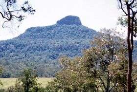 Wilsons Peak, photographed from New South Wales | |
| Highest point | |
| Elevation | 1,230 m (4,040 ft) |
| Coordinates | 28°15′S 152°29′E / 28.250°S 152.483°ECoordinates: 28°15′S 152°29′E / 28.250°S 152.483°E [2] |
| Geography | |
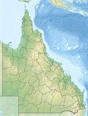 Wilsons Peak Location in Queensland | |
| Location | Queensland, Australia |
Wilsons Peak[2] (Aboriginal: Jirramen[3]) 1,230 m (4,040 ft) is a steep mountain in Queensland, Australia which is covered in dense rainforest. It marks the intersection of the Great Dividing Range with the McPherson Range in the Scenic Rim region. The Queensland and New South Wales border fence also leads up the middle of it.
Local Aboriginals referred to the mountain as "Jirramen," which is Uragapul for knee. This is derived from the fact that the shape of the top of the mountain bears some resemblance to a human knee.[1] The mountain was named by Captain Patrick Logan, the notoriously brutal commander of the Moreton Bay penal settlement, in honour of a colleague he served with at Moreton Bay.
The local Aboriginal tribe used the peak to send a series of smoke signals along the Main Range. The other peaks used for the series of signals are: Mount Roberts, Doubletop, and Mount Mitchell.
See also
References
- 1 2 Fassifern Centenary Book (1944) pI24; Thomas Hall, A Short History of the Downs Blacks, known as the Blucher tribe (Warwick, 1917) pp.39-40.
- 1 2 "Wilsons Peak". Gazeteer of Australia. Geoscience Australia. Retrieved 2008-11-02.
- ↑ Steele, John Gladstone; Tylee Memorial Collection (1983), Aboriginal Pathways in South East Queensland and the Richmond River, St. Lucia, Qld. University of Queensland, ISBN 978-0-7022-1943-6