County of Lowan
| Lowan Victoria | |||||||||||||||
|---|---|---|---|---|---|---|---|---|---|---|---|---|---|---|---|
 Location in Victoria | |||||||||||||||
| |||||||||||||||
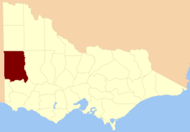
The County of Lowan is one of the 37 counties of Victoria which are part of the cadastral divisions of Australia, used for land titles. The northern boundary of the county is at 36°S. Larger towns include Dimboola, Edenhope and Kaniva. The county was proclaimed in 1871 together with the other counties of the Wimmera Land District.
Parishes
Parishes within the county:
- Arapiles
- Awonga
- Babatchio
- Balrootan
- Bambadin
- Banu Bonyit
- Beewar
- Benayeo
- Berontha
- Bogalara part in the County of Follett
- Boikerbert
- Booroopki
- Bringalbart
- Carchap
- Catiabrim
- Charam
- Connangorach
- Connewirrecoo
- Cooack
- Coynallan
- Curtayne
- Daahl
- Dahwedarre
- Darragan
- Dimboola part in the County of Borung
- Ding-a-ding
- Dinyarrak
- Dollin part in the County of Borung
- Dopewora
- Duchembegarra
- Durndal
- Durong
- Edenhope
- Gerang Gerung
- Goroke
- Gymbowen
- Harrow
- Jallakin
- Jilpanger
- Jungkum
- Kadnook
- Kalingur
- Kaniva
- Karnak
- Kiata
- Kinimakatka
- Konnepra
- Koonik Koonik
- Kout Narin
- Lawloit
- Leeor
- Lillimur
- Lorquon
- Lowan
- Meereek
- Minimay
- Mirampiram
- Mockinya part in the County of Borung
- Moray
- Morea
- Mortat
- Murrandarra
- Murrawong
- Nateyip
- Natimuk
- Neuarpur
- Ni Ni
- Nurcoung
- Nurrabiel
- Peechember
- Pengana
- Perenna
- Pomponderoo
- Propodollah
- Spinifex
- Tallageira
- Tarranginnie
- Telangatuk
- Tooan
- Toolondo
- Toolongrook
- Toonambool
- Tullyvea
- Turandurey
- Tyar
- Warraquil
- Watchegatcheca
- Winiam
- Wombelano
- Woorak
- Woraigworm
- Wytwarrone
- Yallakar
- Yanac-a-yanac
- Yanipy
- Yarrangook
- Yarrock
- Yat Nat
- Yearinga
- Zenobia
- [1]
References
- ↑ Rootsweb Genealogy, Victorian Counties, retrieved 2008-09-20
- Research aids, Victoria 1910
- Map of the counties of Lowan, Borung and Kara Kara showing colony and parish boundaries, main roads, telegraph lines and railways. 1886. National Library of Australia
Coordinates: 36°50′S 141°30′E / 36.833°S 141.500°E
This article is issued from
Wikipedia.
The text is licensed under Creative Commons - Attribution - Sharealike.
Additional terms may apply for the media files.