Chièvres
- For the lord of Chièvres, advisor to Emperor Charles V, see: William de Croÿ.
| Chièvres | |||
|---|---|---|---|
| Municipality | |||
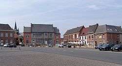 Market Place of Chièvres | |||
| |||
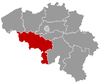
 Chièvres Location in Belgium
Location of Chièvres in Hainaut 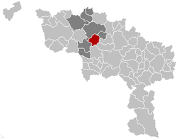 | |||
| Coordinates: 50°35′N 03°48′E / 50.583°N 3.800°ECoordinates: 50°35′N 03°48′E / 50.583°N 3.800°E | |||
| Country | Belgium | ||
| Community | French Community | ||
| Region | Wallonia | ||
| Province | Hainaut | ||
| Arrondissement | Ath | ||
| Government | |||
| • Mayor | Michel Miroir (PS) | ||
| • Governing party/ies | PS, MR | ||
| Area | |||
| • Total | 46.91 km2 (18.11 sq mi) | ||
| Population (1 January 2017)[1] | |||
| • Total | 6,913 | ||
| • Density | 150/km2 (380/sq mi) | ||
| Postal codes | 7950, 7951 | ||
| Area codes | 068 | ||
| Website | www.chievres.be | ||

Chièvres is a Walloon municipality located in the Belgian province of Hainaut. On January 1, 2006, Chièvres had a total population of 6,198. The total area is 46.91 km² which gives a population density of 132 inhabitants per km². Chièvres Air Base is located in the municipality.
The municipality consists of the following sub-municipalities: Chièvres proper, Grosage, Huissignies, Ladeuze, Tongre-Saint-Martin, and Tongre-Notre-Dame.
In 1918 the town was delivered by the 5th Battalion of the Gordon Highlanders from four years of military occupation during the First World War. The event was commemorated by the naming of one of the town's main streets as Rue Dudley Gordon after the battalion's Lieutenant-Colonel, the Lord Dudley Gordon, who was presented with the key to the town of Chièvres. In return, a present was made to the town of the flag under which the 5th Battalion had fought since 1915.[2]
References
External links

Places adjacent to Chièvres | ||||||||||
|---|---|---|---|---|---|---|---|---|---|---|
| ||||||||||