Estinnes
| Estinnes | |||
|---|---|---|---|
| Municipality | |||
.JPG) Basilica of Notre-Dame de Bonne-Espérance | |||
| |||
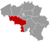
 Estinnes Location in Belgium
Location of Estinnes in Hainaut  | |||
| Coordinates: 50°24′N 04°06′E / 50.400°N 4.100°ECoordinates: 50°24′N 04°06′E / 50.400°N 4.100°E | |||
| Country | Belgium | ||
| Community | French Community | ||
| Region | Wallonia | ||
| Province | Hainaut | ||
| Arrondissement | Thuin | ||
| Government | |||
| • Mayor | Etienne Quenon | ||
| • Governing party/ies | EMC | ||
| Area | |||
| • Total | 72.73 km2 (28.08 sq mi) | ||
| Population (1 January 2017)[1] | |||
| • Total | 7,736 | ||
| • Density | 110/km2 (280/sq mi) | ||
| Postal codes | 7120 | ||
| Area codes | 064 | ||
| Website | www.estinnes.be | ||


Estinnes is a Belgian municipality located in the Walloon province of Hainaut. On 1 January 2006 Estinnes had a total population of 7,413. The total area is 72.73 km² which gives a population density of 102 inhabitants per km².
The municipality consists of the following sub-municipalities: Croix-lez-Rouveroy, Estinnes-au-Mont, Estinnes-au-Val, Fauroeulx, Haulchin, Peissant, Rouveroy, Vellereille-les-Brayeux, and Vellereille-le-Sec.
Estinnes was the location, on 1 March 744, of the second reform council organized by Saint Boniface.[2]
Near Estinnes is a wind farm with 11 wind turbines of Enercon E-126 type, 198.5 metres (651 ft) high.

View of Bonne-Espérance Abbey (1130), in Estinnes (Vellereille-les-Brayeux)
References
- ↑ Population per municipality as of 1 January 2017 (XLS; 397 KB)
- ↑ Dierkens, Alain (1984). "Superstitions, christianisme et paganisma à la fin de l'epoque mérovingienne: A propos de l'Indiculus superstitionem et paganiarum". In Hervé Hasquin. Magie, sorcellerie, parapsychologie. Brussels: Éditions de l'Université de Bruxelles. pp. 9–26.
External links

Places adjacent to Estinnes | ||||||||||
|---|---|---|---|---|---|---|---|---|---|---|
| ||||||||||
This article is issued from
Wikipedia.
The text is licensed under Creative Commons - Attribution - Sharealike.
Additional terms may apply for the media files.