Honnelles
| Honnelles | |||
|---|---|---|---|
| Municipality | |||
.jpg) Angre | |||
| |||
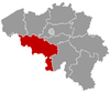
 Honnelles Location in Belgium
Location of Honnelles in Hainaut 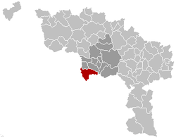 | |||
| Coordinates: 50°21′N 03°43′E / 50.350°N 3.717°ECoordinates: 50°21′N 03°43′E / 50.350°N 3.717°E | |||
| Country | Belgium | ||
| Community | French Community | ||
| Region | Wallonia | ||
| Province | Hainaut | ||
| Arrondissement | Mons | ||
| Government | |||
| • Mayor | Bernard Paget (PS) | ||
| • Governing party/ies | PS | ||
| Area | |||
| • Total | 43.65 km2 (16.85 sq mi) | ||
| Population (1 January 2017)[1] | |||
| • Total | 5,183 | ||
| • Density | 120/km2 (310/sq mi) | ||
| Postal codes | 7387 | ||
| Area codes | 065 | ||
| Website | www.honnelles.be | ||


Honnelles is a Walloon municipality located in the Belgian province of Hainaut. On 1 January 2006 Honnelles had a total population of 4,998. The total area is 43.65 km² which gives a population density of 114 inhabitants per km².
Honnelles is located 18 kilometres (11 mi) southwest of Mons, 16 kilometres (9.9 mi) east of the French city Valenciennes, 50 kilometres (31 mi) west of Charleroi and 72 kilometres (45 mi) southwest of Brussels.
The municipality includes the localities of Angre, Angreau, Athis, Autreppe, Erquennes, Fayt-le-Franc, Marchipont, Montignies-sur-Roc, Onnezies and Roisin.
References
- ↑ Population per municipality as of 1 January 2017 (XLS; 397 KB)
External links

Places adjacent to Honnelles | ||||||||||
|---|---|---|---|---|---|---|---|---|---|---|
| ||||||||||
This article is issued from
Wikipedia.
The text is licensed under Creative Commons - Attribution - Sharealike.
Additional terms may apply for the media files.