Saint-Ghislain
| Saint-Ghislain | |||
|---|---|---|---|
| Municipality | |||
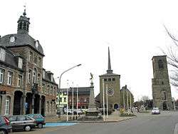 Saint-Ghislain: the former town hall (1752), the new church, and the tower of the old church (16th century) | |||
| |||
 Saint-Ghislain Location in Belgium
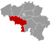
Location of Saint-Ghislain in Hainaut  | |||
| Coordinates: 50°27′N 03°49′E / 50.450°N 3.817°ECoordinates: 50°27′N 03°49′E / 50.450°N 3.817°E | |||
| Country | Belgium | ||
| Community | French Community | ||
| Region | Wallonia | ||
| Province | Hainaut | ||
| Arrondissement | Mons | ||
| Government | |||
| • Mayor | Daniel Olivier | ||
| • Governing party/ies | PS | ||
| Area | |||
| • Total | 70.18 km2 (27.10 sq mi) | ||
| Population (1 January 2017)[1] | |||
| • Total | 23,207 | ||
| • Density | 330/km2 (860/sq mi) | ||
| Postal codes | 7330-7334 | ||
| Area codes | 065 | ||
| Website | www.saint-ghislain.be | ||


Saint-Ghislain (French pronunciation: [sɛ̃ ɡilɛ̃]; Picard: Sint-Guilin) is a Walloon municipality located in the Belgian province of Hainaut. On 1 January 2006 the municipality had 22,466 inhabitants. The total area is 70.18 square kilometres (27.10 sq mi), giving a population density of 320 inhabitants per square kilometre (830/sq mi).
History
The town is named after Saint Ghislain. In the 7th century, with two unknown disciples Ghislain made a clearing in the vicinity of Castrilocus (now Mons), later taking up his abode at a place called Ursidongus, where he built an oratory or chapel dedicated to Saints Peter and Paul. Ursidongus was later named after him.
Economy
Google chose Saint-Ghislain in 2007 to host its new major European datacenter. As of October 2011 Google currently has 12 people employed full-time.
People born in Saint-Ghislain
- Johannes Ockeghem, composer (between 1410 and 1425)
References
- ↑ Population per municipality as of 1 January 2017 (XLS; 397 KB)
External links

Places adjacent to Saint-Ghislain | |
|---|---|
| Authority control |
|---|