Lobbes
| Lobbes | ||
|---|---|---|
| Municipality | ||
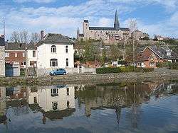 Lobbes on the river Sambre | ||
| ||
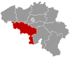
 Lobbes Location in Belgium
Location of Lobbes in Hainaut 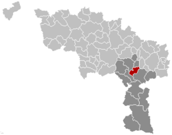 | ||
| Coordinates: 50°21′N 04°15′E / 50.350°N 4.250°ECoordinates: 50°21′N 04°15′E / 50.350°N 4.250°E | ||
| Country | Belgium | |
| Community | French Community | |
| Region | Wallonia | |
| Province | Hainaut | |
| Arrondissement | Thuin | |
| Government | ||
| • Mayor | Marcel Basile (cdH) | |
| • Governing party/ies | MR, PS | |
| Area | ||
| • Total | 32.08 km2 (12.39 sq mi) | |
| Population (1 January 2017)[1] | ||
| • Total | 5,777 | |
| • Density | 180/km2 (470/sq mi) | |
| Postal codes | 6540, 6542, 6543 | |
| Area codes | 071 | |
| Website | www.lobbes.be | |
Lobbes is a Walloon municipality located in the Belgian province of Hainaut. On January 1, 2006, Lobbes had a total population of 5,499. The total area is 32.08 km² which gives a population density of 171 inhabitants per km².
The municipality consists of the following sub-municipalities: Lobbes proper, Mont-Sainte-Geneviève, Sars-la-Buissière, and Bienne-lez-Happart.
The town grew up round Lobbes Abbey, a religious house established here in about 650.
The tramway of the ASVi runs through Lobbes.
Births
- Jonas van Genechten, professional road bicycle racer
- Alfred Wotquenne, musical bibliographer
- Romain Zingle, professional cyclist
References
- ↑ Population per municipality as of 1 January 2017 (XLS; 397 KB)
External links

Places adjacent to Lobbes | |
|---|---|
This article is issued from
Wikipedia.
The text is licensed under Creative Commons - Attribution - Sharealike.
Additional terms may apply for the media files.