Estaimpuis
| Estaimpuis Steenput (Dutch) | ||
|---|---|---|
| Municipality | ||
 Néchin | ||
| ||
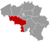
 Estaimpuis Location in Belgium
The municipality in the province of Hainaut 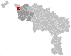 | ||
| Coordinates: 50°42′N 03°16′E / 50.700°N 3.267°ECoordinates: 50°42′N 03°16′E / 50.700°N 3.267°E | ||
| Country | Belgium | |
| Community | French Community | |
| Region | Wallonia | |
| Province | Hainaut | |
| Arrondissement | Tournai | |
| Government | ||
| • Mayor | Daniel Senesael (PS) | |
| • Governing party/ies | PS | |
| Area | ||
| • Total | 31.75 km2 (12.26 sq mi) | |
| Population (1 January 2017)[1] | ||
| • Total | 10,333 | |
| • Density | 330/km2 (840/sq mi) | |
| Postal codes | 7730 | |
| Area codes | 069 | |
| Website | www.estaimpuis.be | |

Estaimpuis (in Dutch Steenput) is a Walloon municipality of Belgium located in the province of Hainaut. It consists of the former municipalities of Estaimpuis, Bailleul, Belgium, Estaimbourg, Évregnies, Leers-Nord, Néchin, and Saint-Léger, Estaimpuis.
Geography
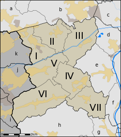
The different sections of Estaimpuis
Villages (former municipalities) in the municipality:
- Estaimpuis (I)
- Évregnies (II)
- Saint-Léger (III)
- Estaimbourg (IV)
- Leers-Nord (V)
- Néchin (VI)
- Bailleul (VII)
Neighbouring villages (and the municipalities to which they belong) in Belgium:
- Herseaux (Mouscron) (a)
- Dottignies (Mouscron) (b)
- Espierres (Spiere-Helkijn) (c)
- Warcoing (Pecq) (d)
- Pecq (Pecq) (e)
- Esquelmes (Pecq) (f)
- Ramegnies-Chin (Tournai) (g)
- Templeuve (Tournai) (h)
Neighbouring municipalities in France:
Gallery
 Main entrance of the Château de Bourgogne in Estaimbourg
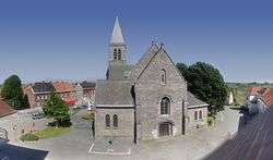
 St. Barthelemy church
 Château de la Royère, engraving ca. 1810 by J B de Jonghe
References
- ↑ Population per municipality as of 1 January 2017 (XLS; 397 KB)
External links

Places adjacent to Estaimpuis | |
|---|---|
This article is issued from
Wikipedia.
The text is licensed under Creative Commons - Attribution - Sharealike.
Additional terms may apply for the media files.