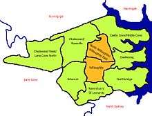
Willoughby, New South Wales
| Willoughby Sydney, New South Wales | |||||||||||||||
|---|---|---|---|---|---|---|---|---|---|---|---|---|---|---|---|
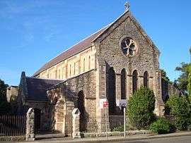 St Stephens Anglican Church | |||||||||||||||
| Population | 6,540 (2016 census)[1] | ||||||||||||||
| • Density | 2,031/km2 (5,260/sq mi) | ||||||||||||||
| Established | 1850s | ||||||||||||||
| Postcode(s) | 2068 | ||||||||||||||
| Area | 3.22 km2 (1.2 sq mi) | ||||||||||||||
| Location | 8 km (5 mi) north of Sydney CBD | ||||||||||||||
| LGA(s) | City of Willoughby | ||||||||||||||
| State electorate(s) | Willoughby | ||||||||||||||
| Federal Division(s) | North Sydney | ||||||||||||||
| |||||||||||||||
Willoughby is a suburb located on the lower North Shore of Sydney, in the state of New South Wales, Australia 8 kilometres north of the Sydney central business district, in the local government area of the City of Willoughby.
The City of Willoughby takes its name from the suburb but its administrative centre is located in the adjacent suburb of Chatswood, which is the local area's major commercial centre.
History
There is some conjecture as to how Willoughby was named. Some historians believe it was named after a parish, while others believe that Surveyor-General Sir Thomas Mitchell decided to commemorate Sir James Willoughby Gordon whom he had served during the Peninsular War and was the quartermaster-general in England when the First Fleet sailed to Botany Bay.
Captain Arthur Phillip's search for "good land, well watered" led to the discovery and colonisation of the rough shores of Roseville Chase, where Samuel Bates built a farm at Echo Point.[2]
Later developments included the building of the first post office in 1871 and the construction of Pommy Lodge in the same year. The latter—a small sandstone building in Penshurst Street—was originally the Congregational Church, which later changed premises. Laurel Bank Cottage, a single-storey home, was constructed in Penshurst Street in 1884. The cottage is now owned and run by the local Masonic Lodge as a function and conference facility.
Circa 1920, Telford Lane—between Fourth Avenue and Eastern Valley Way—was created and paved; the method used was the one pioneered by Thomas Telford in England in the nineteenth century. This lane is one of the few surviving examples of the Telford method in Sydney.
In 1934, the Willoughby incinerator was built in Small Street, after a design by Walter Burley Griffin. It has been described as "a particularly successful example of an industrial building integrating function with site."[3] Like Telford Lane, the incinerator is listed on the (now defunct) Register of the National Estate.
Heritage listings
Willoughby has a number of heritage-listed sites, including:
- 85-87 Penshurst Street: Laurelbank[4]
- 2 Small Street: Walter Burley Griffin Incinerator, Willoughby[5]
Commercial area
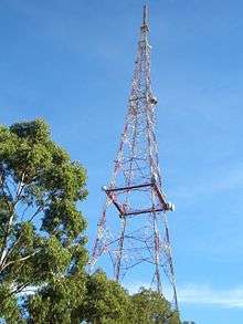
Willoughby has a number of small shops, restaurants and hotels and is also home to the headquarters of the Nine Network, under the callsign of TCN-9. Next to this site is the TXA TV tower which at 233 metres high is the tallest in Australia. There are several small groupings of shops, the majority of which are on Mowbray Road, Willoughby Road, Penshurst Street and High Street.
Parks and recreation
Bicentennial Reserve which includes Hallstrom Park, features a soccer field, T Ball & softball fields and a children's playground. Willoughby Leisure Centre features a 25m lap pool, spas, children's pool, swim school, gym, basketball courts, netball courts and baseball field. Flat Rock Gully, built on an old rubbish tip, is bushland with two walking tracks to Long Bay, following the creek line.
- Carlson Park
- Julian St Park
- Willoughby Squash courts
- Hallstrom Park
- Willoughby Park
Transport
Artarmon is the nearest station for Willoughby's residents, on the western border of the suburb. Also a number of bus routes cover the area. It is close to St Leonards and Chatswood railway stations. The Gore Hill Freeway, a major arterial route into the Sydney CBD, runs along the southern border of Willoughby, with exit from the freeway from Reserve Road and entry from Reserve Road and Willoughby Road. Bus Routes serving Willoughby include:
- 272 North Willoughby - City Wynyard via Freeway
- 343 Chatswood - Kingsford via Crows Nest, North Sydney, City & Waterloo
- 257 Chatswood - Balmoral Beach via Neutral Bay
- 267 Chatswood - Crows Nest via Northbridge
- M40 Chatswood - Bondi Junction via Freeway & City
Schools
- Willoughby Public School (K - Year 6)
- Willoughby Girls High School (Year 7 - Year 12, girls only)
- St Thomas' Catholic Primary School (K - Year 6, Catholic School)
Other
- Willoughby Fire Station, Laurel Street
- 1st Willoughby Scouts, Laurel Street
- Bridgeview Hotel, Willoughby Road
- The Willoughby Hotel, Penshurst Street
Churches
Population
In the 2016 Census, there were 6,540 people in Willoughby. 62.5% of people were born in Australia. The next most common countries of birth were England 4.7%, China 3.4%, New Zealand 2.2% and Hong Kong 2.0%. 68.9% of people only spoke English at home. Other languages spoken at home included Mandarin 4.3%, Cantonese 4.1%, Armenian 2.2%, Japanese 2.1% and Italian 1.7%. The most common responses for religion were No Religion 32.4%, Catholic 28.4% and Anglican 13.7%.[1]
Willoughby is known for a large Armenian community, who arrived in the area in the 1960s-1970s. More Armenian families made their home there once an Armenian Apostolic Church was built on Macquarie Street, Chatswood, close to the border with Willoughby. Willoughby contains several Armenian Churches and Community Centres (Cultural Clubs). It is home to the first Armenian Saturday School which still operates on Saturdays at Willoughby Girls High.
Notable residents
- John Davies, an Olympic swimmer who won gold for Australia in the 1952 Summer Olympics was from the suburb
- Matthew Reilly, best-selling author
- Evonne Goolagong, tennis legend
- Melissa Ippolito, actress
- Doc Neeson, Lead singer of The Angels
Gallery
Heritage
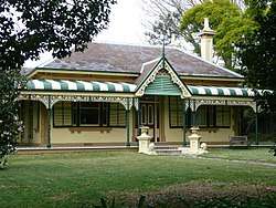 Laurel Bank Cottage (1884)
Griffin_incinerator_Willoughby_089.jpg) Incinerator designed by Walter Burley Griffin (1934)
Incinerator designed by Walter Burley Griffin (1934)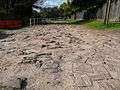 Telford Lane (c.1920)
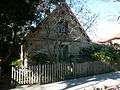 Pommy Lodge (1871)
References
- 1 2 Australian Bureau of Statistics (27 June 2017). "Willoughby (State Suburb)". 2016 Census QuickStats. Retrieved 9 March 2018.

- ↑ The Book of Sydney Suburbs, Compiled by Frances Pollon, Angus & Robertson Publishers, 1990, Published in Australia ISBN 0-207-14495-8, page 271
- ↑ The Heritage of Australia, Macmillan Company, 1981, p.2/122
- ↑ "Laurelbank, New South Wales State Heritage Register (NSW SHR) Number H00657". New South Wales State Heritage Register. Office of Environment and Heritage. Retrieved 18 May 2018.
- ↑ "Walter Burley Griffin Incinerator, New South Wales State Heritage Register (NSW SHR) Number H00084". New South Wales State Heritage Register. Office of Environment and Heritage. Retrieved 18 May 2018.
External links
| Wikimedia Commons has media related to Willoughby, New South Wales. |
- Willoughby, Willoughby City Council - community profile
- North Willoughby/Willoughby East, Willoughby City Council - community profile
- Willoughby City Council - Official Willoughby City Council website
- Willoughby Girls High School - Official Willoughby Girls High School website
- Willoughby Public School - Official Willoughby Public School website
- 1st Willoughby Scouts - 1st Willoughby Scouts Website
- Willoughby District Historical Society
Coordinates: 33°48′27″S 151°12′05″E / 33.80739°S 151.20131°E