Abazai
| Abazai | |
|---|---|
| Union council and town | |
 Abazai Location in Pakistan | |
| Coordinates: 34°19′7″N 71°35′35″E / 34.31861°N 71.59306°E | |
| Country | Pakistan |
| Region | Khyber Pakhtunkhwa |
| District | Charsadda District |
| Tehsil | Tangi Tehsil |
| Time zone | UTC+5 (PST) |
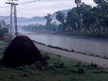
Abazai is a town and union council in Charsadda District of Khyber Pakhtunkhwa province of Pakistan.[1] It is part of Tangi Tehsil and is located at 34°19'7N 71°35'35E and has an altitude of 320 metres (1053 feet)[2] lying to the north-west of the district capital Charsadda and 24 miles north of the provincial capital Peshawar on the left bank of the Swat river, and a mile from its exit from the hills.[3]
History
During British rule, it was a fort and village of Charsadda Tehsil - then part of Peshawar District.
The Imperial Gazetteer of India, compiled over a century ago describes the village and fort as follows:[3]
| “ | The river, here 150 yards wide, is crossed by a ferry, and is the highest point in British territory where a ferry is stationed. The fort, which lies between Abazai village and the hills, was constructed in 1852, and has been very effective in preventing raids by the Utman Khel and Mohmands on British territory. It was made over to the border military police in 1894, and is held by 30 men of this force. Its chief interest now consists in the fact that it is close to the headworks of the SWĀT RIVER CANAL. | ” |
Agriculture
Agriculture is the main livelihood of Abazai's residents. The major crops grown in the region are Wheat, Maize, sugarcane, fruits and vegetables . Fruits specially Mangoes are very famous in Summer season in Abazai. Mangoes of Abazai are of the finest quality a nature can produce due to which they are very famous not only in abazai but also in Khyber Pakhtunkhwa and Pakistan. In winter orange (fruit), Kinnow and sugarcane is grown by the residents and the Jaggery, made from cane juice are very popular .
References
Coordinates: 34°19′7″N 71°35′35″E / 34.31861°N 71.59306°E