Carigara, Leyte
| Carigara | |
|---|---|
| Municipality | |
| Municipality of Carigara | |
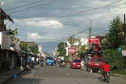 Downtown area | |
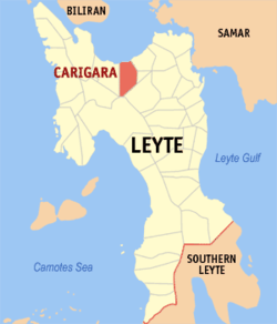 Map of Leyte with Carigara highlighted | |
.svg.png) Carigara Location within the Philippines | |
| Coordinates: 11°18′N 124°41′E / 11.3°N 124.68°ECoordinates: 11°18′N 124°41′E / 11.3°N 124.68°E | |
| Country |
|
| Region | Eastern Visayas (Region VIII) |
| Province | Leyte |
| District | 2nd district of Leyte |
| Barangays | 49 (see Barangays) |
| Government [1] | |
| • Type | Sangguniang Bayan |
| • Mayor | Eduardo Ong |
| • Electorate | 32,501 voters (2016) |
| Area [2] | |
| • Total | 117.86 km2 (45.51 sq mi) |
| Population (2015 census)[3] | |
| • Total | 51,345 |
| • Density | 440/km2 (1,100/sq mi) |
| Time zone | UTC+8 (PST) |
| ZIP code | 6529 |
| PSGC | 083715000 |
| IDD : area code | +63 (0)53 |
| Climate type | Tropical rainforest climate |
| Income class | 2nd municipal income class |
| Revenue (₱) | 124,365,044.73 (2016) |
| Native languages |
Waray Tagalog |
| Website |
www |
Carigara, officially the Municipality of Carigara, is a 2nd class municipality in the province of Leyte, Philippines. According to the 2015 census, it has a population of 51,345 people.[3]
It is a town in northern Leyte located right on the shore of Carigara Bay, and surrounded by wide rice fields fanning out towards the mountains in the distance.
History
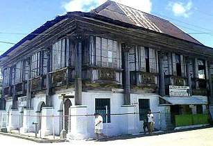

Carigara was originally called Kangara, meaning "that of Gara" or simply "Gara's". Gara was said to have come from Borneo, one of the unnamed companions of the ten datus who landed in Panay and purchased that island from the Ati (or Aeta) chief Marikudo. Later, for phonetic convenience, Kangara became Kalgara and when the Spaniards came, they called the place Carigara; hence its present name. Carigara has a history unique from its neighboring towns. It is the first town established in Eastern Visayas. Its town fiesta which is celebrated every 16 July, commemorates the day of the first coming of the Spaniards dated July 16, 1569. The fiesta that is celebrated almost the entire month of July was dubbed as the Fiesta of the Holy Cross. In the first quarter of 2018, Puregold Jr. was able to penetrate the town market and became operational to serve Carigaran-ons and the neighboring towns. And the first mall was opened as well.

Barangays
Carigara is politically subdivided into 49 barangays. [2]
- Balilit
- Barayong
- Barugohay Central
- Barugohay Norte
- Barugohay Sur
- Baybay (Poblacion)
- Binibihan
- Bislig
- Caghalo
- Camansi
- Canal
- Candigahub
- Canlampay
- Cogon
- Cutay
- East Visoria
- Guindapunan East
- Guindapunan West
- Hiluctogan
- Jugaban (Poblacion)
- Libo
- Lower Hiraan
- Lower Sogod
- Macalpi
- Manloy
- Nauguisan
- Pangna
- Parag-um
- Parina
- Piloro
- Ponong (Poblacion)
- Sagkahan
- San Mateo (Poblacion)
- Santa Fe
- Sawang (Poblacion)
- Tagak
- Tangnan
- Tigbao
- Tinaguban
- Upper Hiraan
- Upper Sogod
- Uyawan
- West Visoria
- Paglaum
- San Juan
- Bagong Lipunan
- Canfabi
- Rizal (Tagak East)
- San Isidro
Demographics
| Population census of Carigara | |||||||||||||||||||||||||||||||||||||||||||||||||
|---|---|---|---|---|---|---|---|---|---|---|---|---|---|---|---|---|---|---|---|---|---|---|---|---|---|---|---|---|---|---|---|---|---|---|---|---|---|---|---|---|---|---|---|---|---|---|---|---|---|
|
| ||||||||||||||||||||||||||||||||||||||||||||||||
| Source: Philippine Statistics Authority [3] [4] [5] [6] | |||||||||||||||||||||||||||||||||||||||||||||||||
In the 2015 census, the population of Carigara, Leyte, was 51,345 people,[3] with a density of 440 inhabitants per square kilometre or 1,100 inhabitants per square mile.
References
- ↑ "Municipality". Quezon City, Philippines: Department of the Interior and Local Government. Retrieved 31 May 2013.
- 1 2 "Province: Leyte". PSGC Interactive. Quezon City, Philippines: Philippine Statistics Authority. Retrieved 12 November 2016.
- 1 2 3 4 Census of Population (2015). "Region VIII (Eastern Visayas)". Total Population by Province, City, Municipality and Barangay. PSA. Retrieved 20 June 2016.
- ↑ Census of Population and Housing (2010). "Region VIII (Eastern Visayas)". Total Population by Province, City, Municipality and Barangay. NSO. Retrieved 29 June 2016.
- ↑ Censuses of Population (1903–2007). "Region VIII (Eastern Visayas)". Table 1. Population Enumerated in Various Censuses by Province/Highly Urbanized City: 1903 to 2007. NSO.
- ↑ "Province of Leyte". Municipality Population Data. Local Water Utilities Administration Research Division. Retrieved 17 December 2016.
External links
| Wikimedia Commons has media related to Carigara, Leyte. |
| Wikisource has the text of the 1911 Encyclopædia Britannica article Carigara. |
| Wikivoyage has a travel guide for Carigara. |
- Philippine Standard Geographic Code
- Philippine Census Information
- Local Governance Performance Management System
Tacloban (capital) | |
| Municipalities |
|
| Component city | |
| Independent component city |
|
| Highly urbanized city |
|