Camarillo, California
| Camarillo, California | ||
|---|---|---|
| City | ||
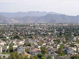 Looking southeast across Camarillo from the northwestern hills on a warm sunny day in late October | ||
| ||
|
Motto(s): "Las Personas Son la Ciudad" ("The People Are the City") | ||
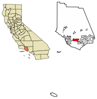 Location of Camarillo in Ventura County, California. | ||
 Camarillo, California Location in the United States | ||
| Coordinates: 34°14′N 119°2′W / 34.233°N 119.033°WCoordinates: 34°14′N 119°2′W / 34.233°N 119.033°W | ||
| Country |
| |
| State |
| |
| County | Ventura | |
| Rail station | 1898 | |
| Incorporated | October 22, 1964[1] | |
| Named for | Adolfo and Juan Camarillo | |
| Government | ||
| • Mayor | Charlotte Craven [2] | |
| • State Senator | Hannah-Beth Jackson (D)[3] | |
| • CA Assembly | Jacqui Irwin (D)[3] | |
| • U. S. Rep. | Julia Brownley (D)[4] | |
| • County supervisor | Kelly Long[5] | |
| Area[6] | ||
| • Total | 19.70 sq mi (51.01 km2) | |
| • Land | 19.69 sq mi (50.99 km2) | |
| • Water | 0.01 sq mi (0.02 km2) 0.08% | |
| Elevation[7] | 177 ft (54 m) | |
| Population (2010)[8] | ||
| • Total | 65,201 | |
| • Estimate (2016)[9] | 67,363 | |
| • Density | 3,421.87/sq mi (1,321.16/km2) | |
| Time zone | UTC-8 (PST) | |
| • Summer (DST) | UTC-7 (PDT) | |
| ZIP codes | 93010–93012[10] | |
| Area code | 805 | |
| FIPS code | 06-10046 | |
| GNIS feature IDs | 1652682, 2409966 | |
| Website |
www | |
Camarillo (/ˌkæməˈriːoʊ/ KAM-ə-REE-oh) is a city in Ventura County in the U.S. state of California. The population was 65,201 at the 2010 census, up from 57,084 at the 2000 census. The Ventura Freeway (U.S. Route 101) is the city's primary thoroughfare. Camarillo is named for Adolfo and Juan Camarillo, two of the few Californios (pre-1848 California natives of Hispanic ancestry) to preserve the city's heritage after the arrival of Anglo settlers. The railroad coast route came through in 1898 and built a station here. Adolfo Camarillo eventually employed 700 workers growing mainly lima beans. Walnuts and citrus were also grown on the ranch. Adolfo bred Camarillo White Horses in the 1920s through the 1960s and was well known for riding them, dressed in colorful Spanish attire, in parades such as the Fiesta of Santa Barbara.
The city grew slowly prior to World War II but the war effort saw the construction of the Oxnard Army Air Field (later Oxnard Air Force Base in 1951, now Camarillo Airport) to the west of town. The community also grew as the new base along with nearby Naval Air Station Point Mugu and a Seabee base at Port Hueneme brought many workers and their families to the area. The grounds of Camarillo State Hospital, which opened in 1936 south of town, are now the campus of California State University, Channel Islands.
As with most cities in Ventura County, it is noted for its resistance to new development.[11] In 2014, the council voted against an 895-acre project that would have extended development on agricultural lands east towards the Conejo Grade.[12]
History
Mexican independence
By the early 1820s, Mexico had gained independence from Spain, and shortly afterward California allied itself with Mexico. The Mexican land grant system was liberalized in 1824 resulting in many large grants in California and the proliferation of Ranchos north of the border. One grant to José Pedro Ruiz created Rancho Calleguas in 1837, in the area that is now Camarillo. The grant was later sold to Juan Camarillo, who had arrived in 1834 as a member of the Hijar-Padres Expedition;[13] it was his sons Adolfo and Juan that are credited with the founding of the town that was to bear their name. The earlier proposed name of Calleguas was rejected as too difficult to pronounce.
St. John's Seminary
In 1927 Don Juan Camarillo, brother of Adolfo, donated 100 acres (0.40 km2) to be used as a seminary to be named in honor of Saint John the Evangelist. The Roman Catholic seminary was opened in 1939 as St. John's Seminary.[14]
Early growth

Camarillo's growth was slow from founding through World War II. In the late 1940s, building lots on Ventura Boulevard, the main downtown street, were being offered for $450 and home lots on the adjoining streets were $250, with few buyers. Travel to and from Los Angeles was difficult, owing to the narrow, tortuous road climbing the Conejo Grade to the east of the city.
The main industry during this period was agriculture, and the area surrounding the small town was blanketed with orange, lemon and walnut groves. The State Mental hospital south of the town was the largest employer. A few houses had sprung up to the north and south of town center. The Oxnard Army Air Field, built during World War II to the west of town, the Naval Air Facility at Point Mugu and the Seabee base at Port Hueneme brought many military personnel to the area, but there was little private industry or other source of non-agricultural employment.
Oxnard AAF closed at the end of World War II, but the Navy facilities remained open, with the airfield upgraded to Naval Air Station Point Mugu and the Seabee base becoming Naval Construction Battalion Center Port Hueneme and Naval Surface Warfare Center Port Hueneme. With the Korean War and associated Cold War tensions, the former Oxnard AAF was reactivated in 1951 as Oxnard Air Force Base, an Air Defense Command / Aerospace Defense Command fighter-interceptor base, that closed again in 1970 and became the present-day Camarillo Airport.
Ventura Freeway (US Route 101)
In the mid-1950s, the Ventura Freeway, which bisects the town, was completed from Los Angeles to points north, making it an easy one-hour trip to Camarillo. The freeway was originally planned to follow the path of Potrero Road, south of Camarillo, which would have completely by-passed the soon-to-be city. However, after much debate, city officials persuaded Caltrans to lay the freeway parallel to Ventura Boulevard, creating the infamously steep descent from the Santa Monica Mountains, known as the Conejo Grade. The grade is about 2.7 miles (4.3 km) and posted as a 7% grade—which translates as about one thousand feet of elevation change in less than three miles (70 meters per kilometer). There is a California Highway Patrol brake inspection station at the top of the grade and a stop is mandatory for all 18-wheel trucks. The completion of the freeway facilitated the growth that followed. In 1962, the population was 7,500 and 3M began construction for the Mincom and Magnetic Tape Divisions, which would ultimately employ 900 people, becoming the largest local employer. That plant briefly housed a factory for 3M spinoff Imation before being closed in 2008.[15] Housing tracts were built where orchards once stood. House prices were $14,000 to $65,000.
Incorporation in 1964
At this time plans were made for the incorporation of the city to control the rapid expansion. Camarillo became a city in 1964 and soon put into place a General Plan and building codes that were to lead to an attractive city environment. In 1964 the closest traffic signal was 2 miles (3.2 km) from the City center on the road to Point Mugu, and the first shopping center and supermarket were under construction. Because of the late date of city incorporation, the local telephone exchange is still listed as part of Oxnard. Much of the city was expected to be developed to the south of Ventura Blvd, however it was to the north that the new city grew, and the land south of Ventura Blvd remains reserved for agricultural use to this day.
Many of the home buyers during the 1960s were military veterans, who had been stationed at one of the local bases during their service. The temperate climate and the living conditions lured them back. With the establishment of both the Pacific Missile Range at NAS Point Mugu and the Naval Civil Engineering Laboratory at Port Hueneme many found employment that utilized their military training. Other newcomers were those who worked and lived in the San Fernando Valley and were willing to endure the commute for the opportunity to raise their families in a smog-free, semirural environment. Still others relocated here with their employers, like 3M, and Harbor Freight Tools who built facilities in and around the city to take advantage of the large workforce. Technicolor Video Services Inc. is the largest DVD duplicator in the world.[16] The members of the original city council (1964) were Ned Chatfield, Stan Daily, Earl Joseph, Tweedy Rouce & Guy Turner.
Old Town
Around 1910, the area for the original "town site" of Camarillo was beginning to be laid out. The town was centered around St. Mary Magdalen Church, which was to serve as the family chapel for Adolfo Camarillo.[17] Today, this area is known as Old Town and is bisected by the Ventura Freeway. On the northern side of the freeway contains a strip of businesses, churches, schools, and parks to hold events such as farmer's markets and the annual Camarillo Street Fair.
Camarillo State Hospital & CSUCI
Camarillo State Mental Hospital was established near the city in the 1930s so that persons suffering from mental illnesses or tuberculosis could recover in Ventura County's balmy climate. Jazzman Charlie Parker's "Relaxin' at Camarillo," written while he was detoxing from heroin addiction, is a tribute to the facility. The song "Camarillo" by punk outfit Fear is also written about the facility. The band Ambrosia released a song called "Ready for Camarillo" on their 1978 Life Beyond L.A. album. "Ready for Camarillo" also appeared as the single B side of their hit "How Much I Feel." The former hospital is the now the site of California State University, Channel Islands. The University has retained the distinctive Mission Revival Style architecture bell tower in the South quad. The band Brazzaville released a video called "Camarillo" in 2007, with mental hospital-like imagery and lyrics concerning lead singer David Brown's relatives' stay in the institution.
The Camarillo State Hospital was closed in the 1990s and remained vacant until the site was converted into California State University, Channel Islands (CSUCI). CSUCI officially opened in August 2002[18] and is now accredited by the WASC.[19]
Mission Oaks
Mission Oaks is the name given by developer Pardee Homes to a 1,312 acres (531 ha) parcel of land located in the north-eastern portion of the city. This parcel was developed as a planned community over the span of 35 years, and was completed in October 2004.[20] The area developed by Pardee Homes makes up approximately 15% of Camarillo's total land. Due to the decades-long timescale of the project, many residents are unaware of Mission Oaks' proprietary nature, and the area east of Lewis Road (State Route 34), south of Somis and north of the 101 Freeway is generally thought of as Mission Oaks regardless of which company built the buildings in the area.[21]
Camarillo Premium Outlets
In the mid-1990s, multiple large retail centers, including one of California's largest outlet malls[22] and movie theater were built south of US 101 and west of Carmen Drive. These new retail centers have provided a large influx of cash to the city; from 1993 to 1998 sales tax revenues nearly doubled from approximately $3.5 million to approximately $6.5 million.[23] On April 23, 2009, several new shops and restaurants opened at the Camarillo Premium Outlets, designated "The Promenade". The Promenade is 220,000 square feet (20,000 m2), while the Premium Outlets is 454,000. The new center has 45 stores and restaurants, bringing the total to about 160[24]
Camarillo Springs Fire
Beginning 7:02 am. on Thursday, May 2, 2013, a major brush fire began in the Camarillo Springs area and burned throughout the area. The community of Dos Vientos and CSUCI were evacuated due to the proximity of the fire. About 15 houses were damaged, but none burned down. 28,000 acres of land was burned by the fire. Finally, on Sunday, May 5, 2013, rain in the area during the night helped firefighters bring the fire under full control.
Geography
According to the United States Census Bureau, the city has a total area of 19.5 square miles (51 km2). 0.015 square miles (0.039 km2) of the area (0.08%) is water.
Camarillo is located in Pleasant Valley[25] at the eastern end of the Oxnard Plain, with the Santa Susana Mountains to the north, the Camarillo Hills to the northwest, the Conejo Valley to the east, and the western reaches of the Santa Monica Mountains to the south.
Climate
This region experiences warm (but not hot) and dry summers, with no average monthly temperatures above 71.6 °F. According to the Köppen Climate Classification system, Camarillo has a warm-summer Mediterranean climate, abbreviated "Csb" on climate maps.[26]
| Climate data for Camarillo Airport, California 1981–2010, extremes 1952–present | |||||||||||||
|---|---|---|---|---|---|---|---|---|---|---|---|---|---|
| Month | Jan | Feb | Mar | Apr | May | Jun | Jul | Aug | Sep | Oct | Nov | Dec | Year |
| Record high °F (°C) | 94 (34) |
90 (32) |
94 (34) |
98 (37) |
98 (37) |
102 (39) |
94 (34) |
96 (36) |
101 (38) |
106 (41) |
99 (37) |
93 (34) |
106 (41) |
| Mean maximum °F (°C) | 80.9 (27.2) |
81.0 (27.2) |
81.6 (27.6) |
85.9 (29.9) |
80.9 (27.2) |
80.0 (26.7) |
82.4 (28) |
83.7 (28.7) |
87.5 (30.8) |
90.3 (32.4) |
85.3 (29.6) |
79.2 (26.2) |
94.5 (34.7) |
| Average high °F (°C) | 65.5 (18.6) |
65.3 (18.5) |
65.8 (18.8) |
68.8 (20.4) |
71.1 (21.7) |
72.5 (22.5) |
75.9 (24.4) |
76.8 (24.9) |
76.6 (24.8) |
73.5 (23.1) |
70.3 (21.3) |
65.5 (18.6) |
70.6 (21.5) |
| Daily mean °F (°C) | 54.4 (12.4) |
53.7 (12.1) |
56.2 (13.4) |
58.3 (14.6) |
61.4 (16.3) |
64.3 (17.9) |
66.9 (19.4) |
67.7 (19.8) |
68.8 (20.4) |
63.1 (17.3) |
58.5 (14.7) |
53.8 (12.1) |
60.6 (15.9) |
| Average low °F (°C) | 43.2 (6.2) |
42.2 (5.7) |
46.6 (8.1) |
47.9 (8.8) |
51.7 (10.9) |
56.2 (13.4) |
58.0 (14.4) |
58.5 (14.7) |
57.0 (13.9) |
52.7 (11.5) |
46.7 (8.2) |
42.1 (5.6) |
50.2 (10.1) |
| Mean minimum °F (°C) | 36.7 (2.6) |
37.8 (3.2) |
39.8 (4.3) |
42.3 (5.7) |
47.0 (8.3) |
51.1 (10.6) |
54.4 (12.4) |
54.2 (12.3) |
52.7 (11.5) |
47.6 (8.7) |
40.4 (4.7) |
36.3 (2.4) |
34.5 (1.4) |
| Record low °F (°C) | 25 (−4) |
30 (−1) |
30 (−1) |
33 (1) |
36 (2) |
42 (6) |
46 (8) |
49 (9) |
43 (6) |
35 (2) |
31 (−1) |
27 (−3) |
25 (−4) |
| Average precipitation inches (mm) | 3.47 (88.1) |
3.71 (94.2) |
2.65 (67.3) |
0.79 (20.1) |
0.31 (7.9) |
0.05 (1.3) |
0.02 (0.5) |
0.04 (1) |
0.18 (4.6) |
0.63 (16) |
1.31 (33.3) |
2.06 (52.3) |
15.22 (386.6) |
| Source: NOAA[27][28] | |||||||||||||
Demographics
| Historical population | |||
|---|---|---|---|
| Census | Pop. | %± | |
| 1960 | 2,359 | — | |
| 1970 | 19,219 | 714.7% | |
| 1980 | 37,797 | 96.7% | |
| 1990 | 52,303 | 38.4% | |
| 2000 | 57,077 | 9.1% | |
| 2010 | 65,201 | 14.2% | |
| Est. 2016 | 67,363 | [9] | 3.3% |
| U.S. Decennial Census[29] | |||
2010
The 2010 United States Census[30] reported that Camarillo had a population of 65,201. The population density was 3,336.3 people per square mile (1,288.1/km²). The racial makeup of Camarillo was 48,947 (75.1%) White, 1,216 (1.9%) African American, 397 (0.6%) Native American, 6,633 (10.2%) Asian, 116 (0.2%) Pacific Islander, 4,774 (7.3%) from other races, and 3,118 (4.8%) from two or more races. Hispanic or Latino of any race were 14,958 persons (22.9%).
The Census reported that 64,705 people (99.2% of the population) lived in households, 155 (0.2%) lived in non-institutionalized group quarters, and 341 (0.5%) were institutionalized.
There were 24,504 households, out of which 8,103 (33.1%) had children under the age of 18 living in them, 13,565 (55.4%) were traditional married couples living together, 2,386 (9.7%) had a female householder with no husband present, 1,078 (4.4%) had a male householder with no wife present. There were 1,257 (5.1%) non-traditional couples or partnerships. 5,986 households (24.4%) were made up of individuals and 3,231 (13.2%) had someone living alone who was 65 years of age or older. The average household size was 2.64. There were 17,029 families (69.5% of all households); the average family size was 3.14.
The population was spread out with 15,115 people (23.2%) under the age of 18, 5,164 people (7.9%) aged 18 to 24, 15,895 people (24.4%) aged 25 to 44, 17,825 people (27.3%) aged 45 to 64, and 11,202 people (17.2%) who were 65 years of age or older. The median age was 40.8 years. For every 100 females, there were 93.7 males. For every 100 females age 18 and over, there were 90.7 males.
There were 25,702 housing units at an average density of 1,315.1 per square mile (507.8/km²), of which 17,059 (69.6%) were owner-occupied, and 7,445 (30.4%) were occupied by renters. The homeowner vacancy rate was 1.4%; the rental vacancy rate was 5.2%. 45,522 people (69.8% of the population) lived in owner-occupied housing units and 19,183 people (29.4%) lived in rental housing units.
2000
As of the census[31] of 2000, there were 57,084 people, 24,376 households, and 15,242 families residing in the city. The population density was 3,015.3 inhabitants per square mile (1,164.2/km²). There were 24,376 housing units at an average density of 1,159.4 per square mile (447.6/km²). The racial makeup of the city was 70.90% White, 1.90% African American, 0.52% Native American, 9.40% Asian, 0.60% Pacific Islander, 13.20% from other races, and 3.90% from two or more races. Hispanic or Latino of any race were 23.10% of the population.
There were 24,376 households out of which 33.0% had children under the age of 18 living with them, 59.7% were married couples living together, 8.2% had a female householder with no husband present, and 28.9% were non-families. 24.1% of all households were made up of individuals and 13.6% had someone living alone who was 65 years of age or older. The average household size was 2.62 and the average family size was 3.12.
In the city, the population was spread out with 25.3% under the age of 18, 6.5% from 18 to 24, 28.5% from 25 to 44, 22.7% from 45 to 64, and 17.0% who were 65 years of age or older. The median age was 39 years. For every 100 females, there were 93.9 males. For every 100 females age 18 and over, there were 90.2 males.
The median income for a household in the city was $62,457, and the median income for a family was $72,676 (these figures had risen to $78,677 and $92,683 respectively as of a 2007 estimate[32]). Males had a median income of $51,507 versus $36,240 for females. The per capita income for the city was $28,635. About 3.6% of families and 5.3% of the population were below the poverty line, including 5.9% of those under age 18 and 4.6% of those age 65 or older.
Economy
Semtech and Salem Communications are based in Camarillo.
Top civilian employers
| # | Employer | # of Employees |
|---|---|---|
| 1 | California State University, Channel Islands | 575 |
| 2 | Pleasant Valley School District | 520 |
| 3 | St. John's Pleasant Valley Hospital | 519 |
| 4 | Marz Farms, Inc. | 500 |
| 5 | Hi-Temp Insulation | 487 |
| 6 | Power-One | 289 |
| 7 | Technicolor Video Services | 288 |
| 8 | SolarWorld | 251 |
| 9 | Ventura County Star | 250 |
| 10 | Teledyne Scientific & Imaging | 226 |
| 11 | Harbor Freight Tools | 188 |
| 12 | Vitesse Semiconductor | 179 |
| 13 | Semtech | 174 |
| 14 | Data Exchange | 168 |
Arts and culture
Libraries

On October 13, 2010, the Camarillo City Council voted 5–0 to withdraw from the Ventura County Library System, and enter into a public-private contract with Library Systems & Services (LSSI) of Germantown, Maryland, a private company that administers several libraries throughout the United States, to provide locally hired staffing and to manage the day-to-day operations of the City of Camarillo Public Library. Under the partnership agreement, the library will remain in the public trust, managed by the City of Camarillo and operated by LSSI.[33] [34] [35]
On January 1, 2011, the City of Camarillo Public Library opened as municipal public library.[36]
Quality of life
The primary public high schools serving Camarillo are Adolfo Camarillo High School in Mission Oaks, and Rio Mesa High School in Strickland between Oxnard and Camarillo, and Rancho Campana High School near the intersection of Lewis Road and Las Posas Road. All three high schools are part of the Oxnard Union High School District.
The Boys and Girls Club of Camarillo has been open since 1967. The Club serves close to 400 kids per day and is primarily funded by donations from the Community. The YMCA has a facility on Village at the Park Drive, and a new library was constructed and opened on March 31, 2007.[37] Many sports leagues, including adult leagues, such as baseball, basketball, football, and the largest AYSO soccer league west of the Mississippi are located in Camarillo. An outdoor in-line hockey rink is in Freedom Park, near the Camarillo Airport.
The incidence of all types of crime committed in the city is far below the national average.[38]
Camarillo Christmas Parade
The Pleasant Valley and Recreation and Park District has hosted the Camarillo Christmas Parade since 1962. The Christmas Parade usually occurs during the first or second weekend in December. Hundreds of organizations and thousands of people participate in the parade. Community Members come from all over to watch the parade. Notable Grand Marshals have been:[39][40]
- Jessica Mendoza (2012) – Olympic Gold Medal Softball Player
- Lisa Guerrero (2011) – TV Personality
- Jack Wilson (infielder) (2010) Seattle Mariners Shortstop
- The Biggest Loser Winners (2009)- Helen Phillips (Season 7) and Michelle Aguilar (Season 6)
- EJ Harrison & Sons (2008) – Local Family Business
- Fernando Vargas (2007) – Boxer
Camarillo resident Walter Brennan also had been a grand marshal in the 1970s.
Parks and recreation
The Pleasant Valley Recreation and Park District operates recreational facilities in Ventura County, including Camarillo.
Parks
- Adolfo Park
- Arneill Ranch Park
- Birchview Park
- Bob Kildee Community Park
- Calleguas Creek
- Camarillo Grove Park
- Carmenita Park
- Charter Oak Park
- Community Center Park [41]
- Dos Caminos Park
- Encanto Park
- Foothill Park
- Freedom Park
- Heritage Park
- Laurelwood Park
- Eldred Lokker Memorial Park
- Mission Oaks Park [42][43]
- Nancy Bush Park
- Pitts Ranch Park
- Pleasant Valley Fields[44][45][46]
- Quito Park
- Springville Park [47]
- Trailside Park
- Valle Lindo Park
- Woodcreek Park
- Woodside Park[48][49][50]
Facilities
Government
At the city's incorporation in 1964, a council-manager form of government was created. The five member city council is elected at large for four-year terms. The council is responsible for establishing policy, enacting laws and making legal and financial decisions for the city. A city manager, hired by the council and answerable to it, is responsible for the day-to-day operation of the city. He is charged with overall management of the five city departments and 97 full-time employees. Services such as water, sewer, trash collection, street maintenance and traffic engineering are provided by a combination of contractors and city employees.
As of January 2017, the mayor of Camarillo is Jan McDonald.[53]
Police services are provided by the Ventura County Sheriff's Department under contract to the city, headquartered in a police station owned by the city. The Sheriff's department helicopter fleet is hangared at Camarillo Airport. Ventura County Fire Department provides fire protection, with five stations within the city limits.
The major source of city funding is sales tax revenue. The mix of retail and commercial businesses in the city provides a stable tax base. The addition of a Factory Outlet Center and a new shopping center added significantly to the sales tax revenues.
Camarillo is a stronghold for the Republican Party, and has nearly twice as many Republican voters as Democratic voters.[54]
Infrastructure
Transportation
Camarillo Airport
Camarillo Airport (ICAO: KCMA, FAA LID: CMA) is a public airport located 3 miles (4.8 km) west of the central business district of Camarillo. The airport has one runway and exclusively serves privately operated general aviation and executive aircraft with no scheduled commercial service.
Rail
Camarillo has one train station, served by both Amtrak's Pacific Surfliner from San Luis Obispo to San Diego and Metrolink's Ventura County Line from Los Angeles Union Station to Montalvo. Nine Pacific Surfliner trains serve the station daily and six Metrolink trains serve the station each weekday. This limited Metrolink service runs only at peak hours in the peak direction of travel (i.e. three morning departures to Los Angeles and three evening arrivals from Los Angeles).[55]
Buses
CAT operates one scheduled bus line on Monday through Friday within Camarillo, and Dial-A-Ride services for the disabled on Monday through Saturday. VISTA operates buses between Camarillo and several nearby cities, including the Conejo Express to the Warner Center area in western Los Angeles County. The city of Camarillo operates a Roadrunner trolley Sunday through Thursday within central Camarillo.
Notable people
- August Ames, Adult Film Actress
- Bryan Anger, NFL punter
- Bill Austin, football player of 1950s[56]
- Bob and Mike Bryan, brothers and professional tennis players, 16 major championships, Olympic gold medalists
- Brandon Cruz, actor and musician
- Kaley Cuoco, actress, star of television's The Big Bang Theory[57]
- Jeremy Fischer, high jumper and coach
- Scott Fujita, linebacker for Cleveland Browns[58]
- Nat Gertler, writer, comics creator (About Comics)
- Ashley Johnson, actress
- Bobby Kimball, wide receiver for Green Bay Packers 1979-80
- Henry Koster, Academy Award-nominated film director
- John D. Lowry, film restoration specialist[59]
- Jessica Mendoza, USA softball player and ESPN baseball broadcaster
- Mad Mike, musician
- Peggy Moran, actress in films from 1938-43
- Cyrus Nowrasteh, screenwriter, producer and director
- Mike Parrott, MLB pitcher for Baltimore Orioles and Seattle Mariners 1977-81
- Duncan Renaldo, Western actor best remembered for playing The Cisco Kid.
- Marla Runyan, Paralympic gold medalist, one of only five athletes to participate in both Paralympics and Olympics
- Robert A. Rushworth, USAF astronaut[60]
- Jimmie Sherfy, Major League Baseball pitcher
- Emil Sitka, actor of many films and television shows, most notably The Three Stooges film shorts
- Jeff Tackett, Major League Baseball catcher 1991-94
- Jason Wade, guitarist and vocalist of rock band Lifehouse
- Patrick Warburton, actor, known for TV series Seinfeld
- Delmon Young, Major League Baseball outfielder 2006-15
In popular culture
The motion pictures Coming Home, Pearl Harbor, Jay and Silent Bob Strike Back, Iron Eagle, Romy and Michele's High School Reunion, and Friday the 13th: A New Beginning were filmed in Camarillo.
Camarillo is sometimes mentioned in literature because of the mental hospital once located there. In Jack Kerouac's The Dharma Bums, he mentions a place "...somewhere near Camarillo where Charlie Parker'd been mad and relaxed back to normal health" (The Dharma Bums, 1).
Frank Zappa referred to the city in his 1973 song "Camarillo Brillo". The city's name is mispronounced so as to rhyme with the second word in the song's title.
Punk band Fear recorded a song entitled "Camarillo" which was used as the theme to the early 1980s cable show New Wave Theatre.
In 2007, American band Brazzaville released a song named The Clouds in Camarillo, which was included in the album 21st Century Girl .
See also

- Adolfo Camarillo
- Camarillo Ranch House
References
- ↑ "California Cities by Incorporation Date". California Association of Local Agency Formation Commissions. Archived from the original (Word) on November 3, 2014. Retrieved August 25, 2014.
- ↑ "Meet your city council". City of Camarillo, CA. Retrieved September 6, 2018.
- 1 2 "Statewide Database". UC Regents. Retrieved October 20, 2014.
- ↑ "California's 26th Congressional District - Representatives & District Map". Civic Impulse, LLC. Retrieved October 5, 2014.
- ↑ "Board of Supervisors". County of Venura. Retrieved February 1, 2015.
- ↑ "2016 U.S. Gazetteer Files". United States Census Bureau. Retrieved Jul 19, 2017.
- ↑ "Camarillo". Geographic Names Information System. United States Geological Survey. Retrieved October 20, 2014.
- ↑ "Camarillo (city) QuickFacts". United States Census Bureau. Retrieved March 20, 2015.
- 1 2 "Population and Housing Unit Estimates". Retrieved June 9, 2017.
- ↑ "ZIP Code(tm) Lookup". United States Postal Service. Retrieved November 7, 2014.
- ↑ "Stop Conejo Creek Development". Conejocreek.org. Retrieved 2013-10-03.
- ↑ Harris, Mike (September 10, 2014) "Camarillo council kills plans for large development" Ventura County Star
- ↑ Lees, Hermine (February 5, 2010). "What's in a name? The cities of the region". The Tidings. Los Angeles: Archdiocese of Los Angeles. p. pastoral region insert page 4. Archived from the original on November 28, 2010. Retrieved December 19, 2014.
- ↑ "History". St. John's Seminary. Retrieved March 2, 2016.
- ↑ Allen, Brad. "IMATION ANNOUNCES FURTHER MANUFACTURING OPTIMIZATION STEPS". Imation Corp. Archived from the original on June 30, 2014. Retrieved May 24, 2012.
- ↑ http://www.technicolor.com/GlobalEnglish/Corporate/About/Pages/default.aspx. Missing or empty
|title=(help) - ↑ Fulton, William. "Camarillo's Old Town Project May Be Model For Other Cities" (PDF). www.insidevc.com.
- ↑ https://www.csuci.edu/about/facts-history/index.htm
- ↑ https://www.csuci.edu/accreditation/
- ↑ Pardee Homes (October 20, 2004). Pardee To Conclude Mission Oaks In Camarillo. Press release.
- ↑ Rochester, Teresa (May 7, 2014) "As Camarillo turns 50, new wave of construction is underway"
- ↑ "Clouds over Camarillo – Despite retail mecca, budget woes loom". Pacific Coast Business Times. January 25, 2009. Retrieved January 29, 2009.
- ↑ William Fulton (2000). Sales and Property Tax Trends In Ventura County, 1987–1998 Archived April 10, 2006, at the Wayback Machine.. Retrieved April 14, 2006.
- ↑ Bruce, Allison. "The Promenade opens in Camarillo". Ventura County Star. Archived from the original on 2013-02-05. Retrieved 2013-11-28.
- ↑ U.S. Geological Survey "Feature Detail Report for: Pleasant Valley" Geographic Names Information System 19 January 1981
- ↑ Climate Summary for Camarillo, California
- ↑ "NOWData - NOAA Online Weather Data". National Oceanic and Atmospheric Administration. Retrieved September 8, 2015.
- ↑ "CA Camarillo AP". National Oceanic and Atmospheric Administration. Retrieved September 8, 2015.
- ↑ "Census of Population and Housing". Census.gov. Archived from the original on May 12, 2015. Retrieved June 4, 2015.
- ↑ "2010 Census Interactive Population Search: CA – Camarillo city". U.S. Census Bureau. Retrieved July 12, 2014.
- ↑ "American FactFinder". United States Census Bureau. Archived from the original on September 11, 2013. Retrieved 2008-01-31.
- ↑ "American FactFinder". Factfinder.census.gov. Retrieved 2013-10-03.
- ↑ Storer, Mark. "Camarillo Council Votes to Leave County Library System." vcstar.com. Ventura County Star, Posted October 14, 2010, Wayback Machine Retrieved February 20, 2011
- ↑ Feng, Bruce. "City of Camarillo Agenda Report: Selection of Library Operator and Approval of Appropriation of Oct. 13, 2010." City of Camarillo. Scribd. Retrieved February 20, 2011
- ↑ "City of Camarillo, CA". Ci.camarillo.ca.us. Archived from the original on June 29, 2014. Retrieved November 28, 2013.
- ↑ "Camarillo Public Library launched, patrons browse", Ventura County Star, January 3, 2011. Retrieved April 7, 2011
- ↑ "Camarillo Library Dedication / Grand Opening : March 31, 2007" (PDF). Ci.camarillo.ca.us. Archived from the original (PDF) on June 29, 2014. Retrieved November 28, 2013.
- ↑ CLRSearch.com (2009). "California Demographics – Crime Statistics". Onboard Informatics. Archived from the original on July 28, 2012. Retrieved March 15, 2011.
- ↑ Lara, Monica. "Camarillo residents come out for Christmas parade » Ventura County Star". Vcstar.com. Retrieved 2013-10-03.
- ↑ "Robosaurus to Appear for Christmas Parade – Los Angeles Times". Articles.latimes.com. 1998-12-09. Retrieved 2013-10-03.
- ↑ "Camarillo Community Band members perform for the love of music » Ventura County Star". Vcstar.com. Retrieved 2012-10-27.
- ↑ Storer, Mark. "Fitness camps support more park hours for Camarillo dogs » Ventura County Star". Vcstar.com. Retrieved 2012-10-27.
- ↑ Potkey, Rhiannon. "Women in league of their own » Ventura County Star". Vcstar.com. Retrieved 2012-10-27.
- ↑ "October half-marathon bears Olympian's name » Ventura County Star". Vcstar.com. Retrieved 2012-10-27.
- ↑ Storer, Mark. "Camarillo bike trail's second phase almost complete » Ventura County Star". Vcstar.com. Retrieved 2012-10-27.
- ↑ "Camarillo family gives back with softball tournament to benefit children with cancer » Ventura County Star". Vcstar.com. Retrieved 2012-10-27.
- ↑ Guzman, Stephanie (August 24, 2012). "Dog park has pet owners wagging tails". Camarillo Acorn. Archived from the original on October 1, 2012. Retrieved October 27, 2012.
- ↑ "City of Camarillo, CA". Ci.camarillo.ca.us. Archived from the original on October 10, 2012. Retrieved October 27, 2012.
- ↑ "Camarillo Parks and Recreational Opportunities in California". Seecalifornia.com. Retrieved 2013-10-03.
- ↑ "Pleasant Valley Parks District in Camarillo, CA". Californiagreensolutions.com. Retrieved 2013-10-03.
- ↑ Guzman, Stephanie (August 24, 2012). "Water a workout for all ages". Camarillo Acorn. Archived from the original on December 3, 2013. Retrieved October 27, 2012.
- ↑ Storer, Mark. "Camarillo skate park will reopen Thursday » Ventura County Star". Vcstar.com. Retrieved 2012-10-27.
- ↑ "Meet Your City Council". City of Camarillo, CA. Archived from the original on September 12, 2015. Retrieved December 30, 2014.
- ↑ McCormack, Don (1999). McCormack's Guides Santa Barbara and Ventura 2000. Mccormacks Guides. Page 77. ISBN 9781929365098.
- ↑ "Amtrak – Camarillo, CA (CML)". Trainweb.org. Retrieved 2013-11-28.
- ↑ O'Gorman, George. "Rutgers' Bill Austin to be honored by NJ Sportswriters", The Trentonian, January 24, 2011. Accessed October 1, 2015. "Now 74 years old and living in Camarillo, Calif. Austin is still a football legend in New Jersey, and especially on the banks of the Raritan.... Austin, a Fanwood native who earned high school stardom at Scotch Plains-Fanwood High, earned All-American honors in two sports at Rutgers as a senior."
- ↑ "Kaley Cuoco Biography – Yahoo Movies Canada". Ca.movies.yahoo.com. Archived from the original on October 4, 2013. Retrieved 2013-10-03.
- ↑ "Hello, I'm Japanese. :: Scott Fujita – Official Website". Scottfujita.com. Retrieved 2013-11-28.
- ↑ "John D. Lowry dies at 79; innovative film-restoration executive". Los Angeles Times. February 1, 2011. Retrieved February 11, 2012.
- ↑ "Robert Rushworth, 68, Test Pilot of the X-15". Obituaries. The New York Times. March 28, 1993. Retrieved 15 March 2017.
External links
| Wikimedia Commons has media related to Camarillo, California. |
| Wikivoyage has a travel guide for Camarillo. |
Destinations from Camarillo | ||||||||||
|---|---|---|---|---|---|---|---|---|---|---|
| ||||||||||
Municipalities and communities of Ventura County, California, United States | ||
|---|---|---|
| Cities | 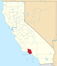 | |
| CDPs | ||
| Unincorporated communities | ||
| Footnotes | ‡This populated place also has portions in an adjacent county or counties | |

| Counties | 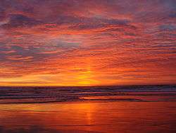 | |
|---|---|---|
| Cities and towns 100k-250k | ||
| Cities and towns 25k-100k | ||
| Cities and towns 10k-25k | ||
| Sub-regions | ||
Counties in italics sometimes included in the definition of the Central Coast | ||