Morro Bay, California
| Morro Bay | ||
|---|---|---|
| City | ||
 .jpg)  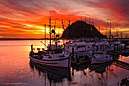  _(32256025836).jpg) .jpg) Counterclockwise: Skyline of Morro Bay, Morro Bay State Park Museum of Natural History, Morro Bay harbor, Morro Strand State Beach, Shell Shop in Morro Bay, Morro Rock and Morro Bay State Park. | ||
| ||
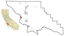 Location in San Luis Obispo County and the state of California | ||
 Morro Bay Location in the United States. | ||
| Coordinates: 35°21′57″N 120°51′00″W / 35.36583°N 120.85000°WCoordinates: 35°21′57″N 120°51′00″W / 35.36583°N 120.85000°W | ||
| Country |
| |
| State |
| |
| County | San Luis Obispo | |
| Founded | 1870 | |
| Incorporated | July 17, 1964[1] | |
| Government | ||
| • Mayor | Jamie L. Irons[2] | |
| Area[3] | ||
| • Total | 10.32 sq mi (26.73 km2) | |
| • Land | 5.30 sq mi (13.73 km2) | |
| • Water | 5.02 sq mi (13.00 km2) 48.63% | |
| Elevation[4] | 62 ft (19 m) | |
| Population (2010)[5] | ||
| • Total | 10,234 | |
| • Estimate (2016)[6] | 10,648 | |
| • Density | 2,007.92/sq mi (775.31/km2) | |
| Time zone | UTC−8 (Pacific Time Zone) | |
| • Summer (DST) | UTC−7 (Pacific Daylight Time) | |
| ZIP codes | 93442–93443 | |
| Area code | 805 | |
| FIPS code | 06-49362 | |
| GNIS feature ID | 1661062 | |
| Website |
www | |
.jpg)
Morro Bay is a waterfront city in San Luis Obispo County, California located along California State Route 1 on California's Central Coast. As of the 2010 census, the city population was 10,234, down from 10,350 at the 2000 census.
History

The prehistory of Morro Bay relates to Chumash settlement, particularly near the mouth of Morro Creek. At least as early as the Millingstone Horizon thousands of years before present, there was an extensive settlement along the banks and terraces above Morro Creek.[7]
The first European land exploration of Alta California, the Spanish Portola expedition, came down Los Osos Valley and camped near today's Morro Bay on September 8, 1769. Franciscan missionary and expedition member Juan Crespi noted in his diary that "we saw a great rock in the form of a round morro".[8]
Morro Rock later gave its name to the town. The descriptive term morro is common to the Spanish, Portuguese and Italian languages, and the word is part of many place names where there is a distinctive and prominent hill-shaped rock formation. Note that the similar Spanish descriptive word "moro" indicates a bluish color rather than a shape.[9]
The first recorded Filipinos to visit America arrived at Morro Bay on October 18, 1587, from the Spanish galleon Nuestra Señora de la Esperanza;[10] one of whom was killed by local Native Americans while scouting ahead.[11]
While governed by Mexico, large land grants split the surrounding area into cattle and dairy ranchos. These ranchos needed shipping to bring in dry goods and to carry their crops, animals, and other farm products to cities. Thus, Morro Bay grew.
The town of Morro Bay was founded by Franklin Riley in 1870 as a port for the export of dairy and ranch products. He was instrumental in the building of a wharf which has now become the Embarcadero. During the 1870s, schooners could often be seen at the Embarcadero picking up wool, potatoes, barley, and dairy products.
Since the beginning of the 20th century, the town has been a center for beach holidays. Tourism is the city's largest industry, coexisting with the town's commercial fishery. The most popular beach is on the north side of Morro Rock, north of the harbor. There are also excellent beaches north and south of the town which are now owned by the State of California.
In the 1940s, Morro Bay developed an abalone fishing industry; it peaked in 1957, and stocks of abalone have declined significantly due to overfishing.[12] Halibut, sole, rockfish, albacore, and many other species are still caught by both commercial and sport vessels. In addition, oysters are aquacultured in the shallow back bay.
A portion of Morro Bay is also designated as a state and national bird sanctuary. It is also a state and national estuary.[13] Much of Morro Bay is a state wildlife area where waterfowl hunting is conducted during the season and is one of the few areas in California where Pacific brant are pursued. In 2007, the California Fish and Game Commission designated Morro Bay as a marine protected area named the Morro Bay State Marine Reserve.[14]
Geography
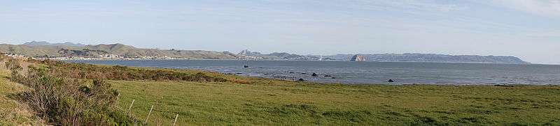
Morro Bay is located at 35°22′45″N 120°51′12″W / 35.37917°N 120.85333°W (35.379043, −120.853354).[15] Morro Bay 35°20′16″N 120°51′05″W / 35.33778°N 120.85139°W is also the name of the large estuary that is situated along the northern shores of the bay itself. The larger bay on which the local area lies is Estero Bay, which also encompasses the communities of Cayucos and Los Osos. The city of Morro Bay is 20 km (12 mi) northwest of San Luis Obispo and is located on Highway 1. Los Osos Creek discharges into Morro Bay.
According to the United States Census Bureau, the city has a total area of 10.3 square miles (27 km2), of which, 5.3 square miles (14 km2) of it is land and 5.0 square miles (13 km2) of it (48.63%) is water.
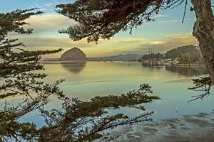
Morro Rock
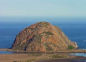
The town's most striking feature is Morro Rock, a 576 foot high volcanic plug[16] which stands at the entrance to the harbor. Originally it was surrounded by water, but the northern channel was filled in to make the harbor.[17] It was quarried from 1889 to 1969,[18] and in 1968, it was designated a Historical Landmark.[19]
The area around the base of Morro Rock is open to visitors, with parking lots and paths. However, climbing the rock itself is prohibited except with a permit,[20][21] both due to risk of injury, and because it is a peregrine falcon reserve.[16][22]
Morro Rock is one in a series of similar plugs that stretch in a line inland called the Nine Sisters. It is possible that the landscape moved over a volcanic hot spot through the ages.
Morro Bay Harbor

Morro Bay is a natural embayment with an artificial harbor constructed by the U.S. Army Corps of Engineers. It is the only all-weather small craft commercial and recreational harbor between Santa Barbara and Monterey. Morro Rock was originally surrounded by water, but the Army built a large artificial breakwater and road across the north end of the harbor, linking Morro Rock and the mainland. Some of the rock used for this and for the artificial breakwaters was quarried from Morro Rock itself. Other rock was imported by barge from Catalina Island. The bay extends inland and parallels the shore for a distance of about 6.4 km (4 miles) south of its entrance at Morro Rock. Morro Bay is recognized for protection by the California Bays and Estuaries Policy.[23]
Only relatively small craft are capable of passing the harbor channel. A large natural sandspit, augmented by breakwaters, protects the harbor from the Pacific Ocean to the west. At its northern end, remains of a bridge that used to connect the shore with the sandspit can be seen. Morro Bay Harbor's channel silts up and must be dredged every three to four years. Previously, the Shark Inlet connected the back bay to the ocean. Some have proposed reopening it to slow the sedimentation that is filling up the bay. There has also been work on reducing erosion in the Chorro Creek watershed to reduce the amount of sediment coming into the bay to form bottom layers of bay mud. Chorro Creek is the bay's largest tributary. It forms an estuary in the back bay between Morro Bay and Los Osos. The second largest tributary, and the only other significant one, is Los Osos Creek, which empties into the far south end of the back bay.


Mariners are strongly urged to seek local advice prior to making use of the channel, especially when whitecaps or wind-blown water is evident or a small craft advisory is in effect, which is very often. The United States Coast Guard regards the harbor as one of the most dangerous in the entire nation, while others put it in the top six on the West Coast of the United States. In 1995, the Army Corps of Engineering deepened and expanded the channel to improve safety. From 1979 to 1987, 21 lives were lost in boating accidents alone. However, many additional deaths have resulted from sightseers and fisherman being swept off the rocks of the breakwater surrounding Morro Rock. They often approach too closely to the waves and are caught off guard when a big wave set comes in. The slippery and jagged rocks only add to the danger. Public access to the breakwater has been revoked and those who venture beyond the signs do so at their own peril.
Coast Guard Station Morro Bay operates three 47-foot Motor Lifeboats. Limited transient vessel services are available. Yachtsmen may wish to contact the Morro Bay Yacht Club. A public boat launch ramp is available at the far south end of the Embarcadero.
The back bay, roughly anything south of the Morro Bay State Park Marina, is very shallow. However, there is some slightly deeper water in the channels. The largest channel continues from the bay's main channel, winding its way towards Los Osos, on the southern end of the bay. The second largest breaks off from the largest about halfway to Los Osos and takes an extremely windy route to the sandspit. A few small channels on the landward side formed by runoff meet the largest channel as well. The narrow, unmarked channels are very hard to navigate and are filled with eel grass, which can snag the boat or clog the propeller. They are easiest to find at low tide, but if the tide is too low, the boat may run aground because the channels are only a few feet deeper than the surrounding water. An alternative to searching for the channels is to cross at very high tide.
During World War II, there was a U.S. Navy base on the north side of Morro Rock where sailors were trained to operate LCVPs. The breakwater on the southwest side of the Rock was built in 1944–45 to protect the LCVPs entering and leaving the harbor. Soldiers from Camp San Luis Obispo would come to Morro Bay and practice loading into the LCVPs. Many of those men were at Normandy on D-Day.
Climate
Morro Bay experiences a warm-summer Mediterranean climate (Köppen Csb) characteristic of coastal California featuring dry, warm summers and wet, mild winters. The city is located next to the Pacific Ocean, which helps moderate temperatures and create an overall pleasant mild year-round climate, resulting in warmer winters and cooler summers compared with places farther inland, such as Atascadero. Summers in Morro Bay are cool for a city located in the 35th parallel north latitude, with July averaging around 60 °F (16 °C). Winters are mild, with January averaging at 55 °F (13 °C) along with around 8 days of measurable precipitation.
| Climate data for Morro Bay, CA (1981–2010 normals, extremes 1959–present) | |||||||||||||
|---|---|---|---|---|---|---|---|---|---|---|---|---|---|
| Month | Jan | Feb | Mar | Apr | May | Jun | Jul | Aug | Sep | Oct | Nov | Dec | Year |
| Record high °F (°C) | 89 (32) |
87 (31) |
92 (33) |
100 (38) |
98 (37) |
86 (30) |
92 (33) |
94 (34) |
101 (38) |
106 (41) |
92 (33) |
81 (27) |
106 (41) |
| Average high °F (°C) | 65.0 (18.3) |
65.6 (18.7) |
66.4 (19.1) |
66.7 (19.3) |
65.7 (18.7) |
66.9 (19.4) |
68.1 (20.1) |
69.1 (20.6) |
70.5 (21.4) |
71.4 (21.9) |
69.2 (20.7) |
64.8 (18.2) |
67.4 (19.7) |
| Daily mean °F (°C) | 54.8 (12.7) |
55.9 (13.3) |
56.8 (13.8) |
57.2 (14) |
57.9 (14.4) |
59.7 (15.4) |
61.6 (16.4) |
62.3 (16.8) |
62.5 (16.9) |
61.8 (16.6) |
58.8 (14.9) |
54.6 (12.6) |
58.7 (14.8) |
| Average low °F (°C) | 44.6 (7) |
46.2 (7.9) |
47.3 (8.5) |
47.7 (8.7) |
50.2 (10.1) |
52.5 (11.4) |
55.0 (12.8) |
55.6 (13.1) |
54.6 (12.6) |
52.2 (11.2) |
48.5 (9.2) |
44.5 (6.9) |
49.9 (9.9) |
| Record low °F (°C) | 23 (−5) |
22 (−6) |
28 (−2) |
31 (−1) |
33 (1) |
39 (4) |
40 (4) |
40 (4) |
41 (5) |
36 (2) |
31 (−1) |
22 (−6) |
22 (−6) |
| Average precipitation inches (mm) | 3.57 (90.7) |
3.77 (95.8) |
3.29 (83.6) |
1.10 (27.9) |
0.43 (10.9) |
0.08 (2) |
0.01 (0.3) |
0.05 (1.3) |
0.24 (6.1) |
0.82 (20.8) |
1.40 (35.6) |
2.72 (69.1) |
17.48 (444) |
| Average precipitation days (≥ 0.01 in) | 7.8 | 9.2 | 7.8 | 4.9 | 1.7 | 0.6 | 0.4 | 0.5 | 1.5 | 3.0 | 5.0 | 7.1 | 49.5 |
| Source: NOAA[25][26] | |||||||||||||
Marine Protected Areas
Morro Bay State Marine Recreational Management Area and Morro Bay State Marine Reserve are marine protected areas offshore from Morro Bay. Like underwater parks, these marine protected areas help conserve ocean wildlife and marine ecosystems.
Economy
Morro Bay's economy is based on small businesses, tourism, and retirees. A number of tourist attractions are found along the shoreline and the streets closest to it, especially the Embarcadero, including restaurants, shops and parks.
Demographics
| Historical population | |||
|---|---|---|---|
| Census | Pop. | %± | |
| 1950 | 1,659 | — | |
| 1960 | 3,692 | 122.5% | |
| 1970 | 7,109 | 92.6% | |
| 1980 | 9,064 | 27.5% | |
| 1990 | 9,664 | 6.6% | |
| 2000 | 10,350 | 7.1% | |
| 2010 | 10,234 | −1.1% | |
| Est. 2016 | 10,648 | [6] | 4.0% |
| U.S. Decennial Census[27] | |||
2010
The 2010 United States Census[28] reported that Morro Bay had a population of 10,234. The population density was 991.5 people per square mile (382.8/km2). The racial makeup of Morro Bay was 8,909 (87.1%) White, 44 (0.4%) African American, 92 (0.9%) Native American, 258 (2.5%) Asian, 9 (0.1%) Pacific Islander, 613 (6.0%) from other races, and 309 (3.0%) from two or more races. Hispanic or Latino of any race were 1,526 persons (14.9%).
The Census reported that 10,073 people (98.4% of the population) lived in households, 36 (0.4%) lived in non-institutionalized group quarters, and 125 (1.2%) were institutionalized.
There were 4,844 households, out of which 919 (19.0%) had children under the age of 18 living in them, 1,972 (40.7%) were opposite-sex married couples living together, 405 (8.4%) had a female householder with no husband present, 217 (4.5%) had a male householder with no wife present. There were 330 (6.8%) unmarried opposite-sex partnerships, and 35 (0.7%) same-sex married couples or partnerships. 1,808 households (37.3%) were made up of individuals and 783 (16.2%) had someone living alone who was 65 years of age or older. The average household size was 2.08. There were 2,594 families (53.6% of all households); the average family size was 2.70.
The population was spread out with 1,530 people (15.0%) under the age of 18, 815 people (8.0%) aged 18 to 24, 2,264 people (22.1%) aged 25 to 44, 3,200 people (31.3%) aged 45 to 64, and 2,425 people (23.7%) who were 65 years of age or older. The median age was 48.9 years. For every 100 females, there were 95.8 males. For every 100 females age 18 and over, there were 93.6 males.
There were 6,320 housing units at an average density of 612.3 per square mile (236.4/km2), of which 2,583 (53.3%) were owner-occupied, and 2,261 (46.7%) were occupied by renters. The homeowner vacancy rate was 3.3%; the rental vacancy rate was 6.3%. 5,218 people (51.0% of the population) lived in owner-occupied housing units and 4,855 people (47.4%) lived in rental housing units.
2000

As of the 2000 census,[29] there were 10,350 people, 4,986 households, and 2,612 families residing in Morro Bay. The population density was 2,006.9 people per square mile (774.4/km2). There were 6,251 housing units at an average density of 1,212.1 per square mile (467.7/km2). The racial makeup of the city was 89.44% White, 0.68% African American, 0.95% Native American, 1.81% Asian, 0.09% Pacific Islander, 4.10% from other races, and 2.95% from two or more races. Hispanic or Latino of any race were 11.43% of the population.
There were 4,986 households out of which 16.7% had children under the age of 18 living with them, 40.5% were married couples living together, 8.3% had a female householder with no husband present, and 47.6% were non-families. 38.0% of all households were made up of individuals and 16.4% had someone living alone who was 65 years of age or older. The average household size was 2.04 and the average family size was 2.65.
In the city, the population was spread out with 15.1% under the age of 18, 8.4% from 18 to 24, 25.4% from 25 to 44, 26.8% from 45 to 64, and 24.2% who were 65 years of age or older. The median age was 46 years. For every 100 females, there were 91.3 males. For every 100 females age 18 and over, there were 89.8 males.
The median income for a household in the city was $34,379, and the median income for a family was $43,508. Males had a median income of $31,073 versus $25,576 for females. The per capita income for the city was $21,687. About 8.1% of families and 13.0% of the population were below the poverty line, including 16.9% of those under age 18 and 5.8% of those age 65 or over.
Morro Bay High School and Del Mar Elementary are the only schools in Morro Bay, California that offers education for grade level K-5th and 9th −12th .[30]
Government
In the California State Legislature, Morro Bay is in the 17th Senate District, represented by Democrat Bill Monning, and in the 35th Assembly District, represented by Republican Jordan Cunningham.[31]
In the United States House of Representatives, Morro Bay is in California's 24th congressional district, which has a Cook PVI of D +4[32] and is represented by Salud Carbajal (D–Santa Barbara).[33]
Power plant

The Dynegy power plant, previously owned by Pacific Gas and Electric Co.(PG&E), Duke Energy, and LSPower (PG&E), has played a large role in Morro Bay, and in providing electricity to the Central Coast and the Central Valley of California (primarily Fresno and Bakersfield). Due to its large tall smokestacks, it is sometimes referred to or known to locals as "Three Fingers". The plant was built in the 1950s, and Dynegy had hoped to modernize it with a new combined cycle plant. The plant was operating at relatively low capacity factors (approximately 5%) under contract with PG&E, due primarily to economics. The plant was staffed with 44 employees. A portion of the city's budget came from taxes on the natural gas the plant burned. The outfall lease with the city was recently approved by the majority of the city council. Activists are opposed to the new plant. The United States Environmental Protection Agency (EPA) and the courts are wrestling with how to interpret the Clean Water Act (CWA) and its applicability to power plants. The EPA has ruled that the local Regional Water Quality Control Boards are responsible for ensuring that the current and the future plant are permitted and regulated.
The modernization proposal was rejected, and the plant closed in February 2014. Continued operation would have required expensive upgrades by 2015. The 650-megawatt plant operated around the clock during the energy crisis of 2000, but the plant had been operating at just one-sixth of that capacity in the recent years preceding its closure.[34] Future uses of the site and/or plant are undetermined, as of December 2016.
Notable people
- Jack LaLanne, American fitness, exercise, nutritional expert and motivational speaker.[35]
- Mel Queen, professional baseball player, coach, scout and executive.[36]
- James Horvath, children's author and illustrator.[37]
In popular culture
- Morro Bay served as the primary setting for Pixar's 2016 film Finding Dory, in which it was revealed that Dory's childhood home was the fictional Marine Life Institute, known as "The Jewel of Morro Bay, California".[38][39]
- Morro Bay is an album by indie pop band Brazzaville, released in 2013. It also included a self-titled song.
- Morro Bay is mentioned with other Californian sights and locations in the Beach Boys song "California Saga: California", released 1973 on the album Holland.
- Morro Bay provides the setting for episode five, season four of television drama series The Affair (2018)
- Morro Bay is the location of the fictional Night City in the Cyberpunk 2020 role-playing game and the forthcoming Cyberpunk 2077 CRPG.[40]
References
- ↑ "California Cities by Incorporation Date". California Association of Local Agency Formation Commissions. Archived from the original (Word) on November 3, 2014. Retrieved August 25, 2014.
- ↑ "Mayor and City Council". City of Morro Bay. Retrieved November 3, 2014.
- ↑ "2016 U.S. Gazetteer Files". United States Census Bureau. Retrieved June 28, 2017.
- ↑ "Morro Bay". Geographic Names Information System. United States Geological Survey. Retrieved October 21, 2014.
- ↑ "Morro Bay (city) QuickFacts". United States Census Bureau. Archived from the original on August 24, 2012. Retrieved April 17, 2015.
- 1 2 "Population and Housing Unit Estimates". Retrieved June 9, 2017.
- ↑ C. Michael Hogan (2008). "Morro Creek". ed. by A. Burnham.
- ↑ Bolton, Herbert E. (1927). Fray Juan Crespi: Missionary Explorer on the Pacific Coast, 1769–1774. HathiTrust Digital Library. pp. 185–186. Retrieved June 18, 2017.
- ↑ Gudde, Erwin G. (1969). California Place Names. Berkeley: University of California Press. p. 212.
- ↑ Mercene, Floro L. (2007). Manila Men in the New World: Filipino Migration to Mexico and the Americas from the Sixteenth Century. The University of the Philippines Press. pp. 38–42. ISBN 971-542-529-1. Retrieved July 1, 2009.
- ↑ Valerie Ooka Pang; Li-Rong Lilly Cheng (1998). Struggling To Be Heard: The Unmet Needs of Asian Pacific American Children. SUNY Press. p. 166. ISBN 978-0-7914-3839-8.
- ↑ Susan McBride and Fred F. Conte. California Abalone Aquaculture Archived January 16, 2009, at the Wayback Machine., California Aquaculture, University of California, Davis.
- ↑ "Morro Bay National Estuary Program". Morro Bay National Estuary Program. Retrieved September 20, 2017.
- ↑ "Morro Bay State Marine Reserve". California Department of Fish and Wildlife. 2016. Retrieved July 17, 2016.
- ↑ "US Gazetteer files: 2010, 2000, and 1990". United States Census Bureau. February 12, 2011. Retrieved April 23, 2011.
- 1 2 Fodor's (December 21, 2010). Fodor's Northern California 2011: With Napa, Sonoma, Yosemite, San Francisco & Lake Tahoe. Random House Digital, Inc. p. 80. ISBN 978-1-4000-0503-1. Retrieved December 25, 2011.
- ↑ "Photo Gallery". Historical Morro Bay. Retrieved July 17, 2016.
- ↑ "Morro Rock". Marquis Publishing. Retrieved July 17, 2016.
- ↑ "Morro Rock". Office of Historic Preservation. Retrieved July 17, 2016.
- ↑ "Rock Climber Rescued". Tolosa Press. March 4, 2015. Retrieved July 17, 2016.
- ↑ "2 tribes clash over climbing Morro Rock". SF Gate. March 18, 2015. Retrieved July 17, 2016.
- ↑ "Morro Rock Beach". City of Morro Bay. Retrieved July 17, 2016.
- ↑ State Water Resources Control Board Water Quality Control Policy for the Enclosed Bays and Estuaries of California (1974) State of California
- ↑ "Otter Information Station". Archived from the original on July 14, 2014. Retrieved June 7, 2014.
- ↑ "NOWData – NOAA Online Weather Data". National Oceanic and Atmospheric Administration. Retrieved September 27, 2015.
- ↑ "CA Morro Bay Fire Dept". National Oceanic and Atmospheric Administration. Retrieved September 27, 2015.
- ↑ "Census of Population and Housing". Census.gov. Retrieved June 4, 2015.
- ↑ "2010 Census Interactive Population Search: CA – Morro Bay city". U.S. Census Bureau. Retrieved July 12, 2014.
- ↑ "American FactFinder". United States Census Bureau. Retrieved January 31, 2008.
- ↑ "Morro Bay High School". San Luis Coastal Unified School District. Retrieved July 17, 2016.
- ↑ "Statewide Database". UC Regents. Retrieved November 24, 2014.
- ↑ "Cook Political Report". Cook Political Report. Retrieved September 1, 2014.
- ↑ "California's 24th Congressional District - Representatives & District Map". Civic Impulse, LLC. Retrieved September 29, 2014.
- ↑ Dynegy officially closes the Morro Bay Power Plant, San Luis Obispo Tribune, February 5, 2014
- ↑ d'Estries, Michael (January 24, 2011). "Jack LaLanne: The first fitness superhero". Mother Nature Network. Retrieved January 25, 2011.
- ↑ "SanLuisObispo.com – Former SLO High standout Mel Queen succumbs to cancer". Archived from the original on October 27, 2014. Retrieved October 27, 2014.
- ↑ "Morro Bay man realizes dream of publishing children's book". The Tribune (San Luis Obispo). Retrieved August 31, 2014.
- ↑ "Disney's 'Finding Dory' movie has Morro Bay connection". sanluisobispo.com. Retrieved March 20, 2017.
- ↑ Martell, Brooke. "Locals react to 'Finding Dory' connection to the Central Coast". ksby.com. Retrieved March 20, 2017.
- ↑ Pondsmith, Mike (August 31, 2018). "Here is where supposedly Cyberpunk takes place in California. Based on rescued girl's locator". reddit.com. Retrieved August 31, 2018.
External links
| Wikimedia Commons has media related to Morro Bay, California. |
| Wikivoyage has a travel guide for Morro Bay. |
- Official website

- Information about Morro Bay
- Morro Bay Guide to Nature, Recreation, Politics, Culture
- Morro Bay High School
- Morro Bay Merchants Association
Municipalities and communities of San Luis Obispo County, California, United States | ||
|---|---|---|
| Cities | 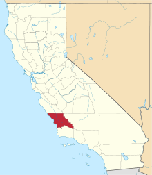 | |
| CDPs | ||
| Unincorporated communities | ||
| Ghost towns | ||
| Counties | 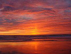 | |
|---|---|---|
| Cities and towns 100k-250k | ||
| Cities and towns 25k-100k | ||
| Cities and towns 10k-25k | ||
| Sub-regions | ||
Counties in italics sometimes included in the definition of the Central Coast | ||