Camarillo Airport
| Camarillo Airport | |||||||||||||||
|---|---|---|---|---|---|---|---|---|---|---|---|---|---|---|---|
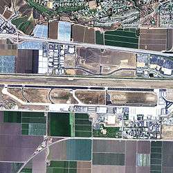 2006 USGS photo | |||||||||||||||
| Summary | |||||||||||||||
| Airport type | Public | ||||||||||||||
| Owner | County of Ventura | ||||||||||||||
| Location | Camarillo, California | ||||||||||||||
| Elevation AMSL | 77 ft / 23 m | ||||||||||||||
| Coordinates | 34°12′50″N 119°05′40″W / 34.21389°N 119.09444°W | ||||||||||||||
| Runways | |||||||||||||||
| |||||||||||||||
| Helipads | |||||||||||||||
| |||||||||||||||
| Statistics (2006) | |||||||||||||||
| |||||||||||||||
Camarillo Airport (ICAO: KCMA, FAA LID: CMA) is a public airport located three miles (5 km) west of the central business district of Camarillo, a city in Ventura County, California, United States.[1] The airport has one runway and exclusively serves privately operated general aviation and executive aircraft with no scheduled commercial service. A separate airfield in the southwest quadrant of the airport is for exclusive use of Light-Sport Aircraft and Ultralights.
According to the FAA's National Plan of Integrated Airport Systems for 2007–2011, it is categorized as a reliever airport.[2]
History
Camarillo Airport was originally established in 1942 when the California State Highway Department constructed an auxiliary landing field with a 5,000 ft (1,500 m) runway, which was later extended to 8,000 ft (2,400 m) in 1951 to accommodate what by then had developed into Oxnard Air Force Base. At the base, Aerospace Defense Command directed the 354th, 437th, and 460th Fighter-Interceptor Squadrons successively.
In the years following the closure of Oxnard AFB in January 1970, the Ventura County actively pursued the acquisition of the former military base property from the Department of Defense for commercial airport use. This initiative ran into public opposition, opposed primarily by local residents concerned about the noise of growing commercial traffic. In 1976, the transfer of the airport was finally approved, provided the runway length was shortened to 6,000 ft by displacing the runway threshold each end, substantially at the eastern end. By 1985, the airport was entirely managed by the Ventura County Department of Airports.[3]
Facilities and aircraft
Camarillo Airport covers an area of 650 acres (260 ha) and contains one runway (8/26) which measures 6,013 x 150 ft (1,833 x 46 m). It has two helipads, both measuring 50 by 50 ft (15 x 15 m).
For a 12-month period ending June 5, 2006, the airport had 153,360 aircraft operations, an average of 420 per day: 98% general aviation, 2% air taxi and <1% military. There are 600 aircraft based at this airport: 84% single engine, 8% multi-engine, 5% ultralights, 3% jet aircraft and 1% helicopters.[1] It is an FAA-towered facility and there are three Fixed-Base Operators are headquartered at the airfield.
- The Camarillo Composite Squadron 61 of the California Wing of the Civil Air Patrol is based at this airfield. The CAP facilities are located near Sky Blue Air, at the east end of the airport.
- The Commemorative Air Force's Southern California Wing and its museum are located to the west of the Waypoint Cafe in two large hangars. Aircraft include the C-46 'China Doll', an F6F Hellcat, F8F Bearcat, P-51 Mustang, Yak-3, Supermarine Spitfire Mark XIV, A6M3 'Zero' model 22, PBJ-1J, two T-6 Texan, and a B-25J, many of which are in flying condition.[4][5] Rides on the P-51 Mustang, PBJ-1J, PT-19, and T-6 Texan are available.[6]
- The Experimental Aircraft Association's Chapter 723 and its facilities are located to the west of CAF museum in two hangars.
- From 1995 to 2012, one of the last Lockheed C-121 Constellations underwent a major restoration and dominated the tarmac. It was flown out to the Yanks Air Museum in Chino, California.[7]
The Ventura County Fire and Sheriff's Departments each support large, separate facilities at opposite ends of the field to support new recruit and recurring refreshment training.
A "Viewport" opened in 2014, providing a kid-friendly area to view the airport activities which had become difficult with increased security concerns.[8]
References
- 1 2 3 FAA Airport Master Record for CMA (Form 5010 PDF), retrieved 2007-03-15
- ↑ FAA National Plan of Integrated Airport Systems: 2007-2011
- ↑ History of Camarillo Airport Archived 2012-02-07 at the Wayback Machine.
- ↑ Ogden, Bob. Aviation Museums and Collections of North America, Sudbourne, England, 2007. ISBN 978-0851303857.
- ↑ Parker, Dana T. Building Victory: Aircraft Manufacturing in the Los Angeles Area in World War II, Cypress, CA, 2013. ISBN 978-0-9897906-0-4.
- ↑ https://www.cafsocal.com/warbird-ride-program/
- ↑ Lawrence, Carol (January 14, 2012). "'Connie' spy plane leaves Camarillo Airport for new home". Ventura County Star. Retrieved 17 April 2017.
- ↑ Foster, Jeremy (June 27, 2014) "Camarillo Airport lands outdoor space for aviation buffs, public" Ventura County Star
External links
- Camarillo Airport at County of Ventura web site
- FAA Airport Diagram (PDF), effective October 11, 2018
- AC-U-KWIK information for KCMA