Dulah, California
| Dulah, California Solimar Beach | |
|---|---|
| Unincorporated community | |
 Dulah, California | |
| Coordinates: 34°18′40″N 119°21′26″W / 34.31111°N 119.35722°WCoordinates: 34°18′40″N 119°21′26″W / 34.31111°N 119.35722°W | |
| Country | United States |
| State | California |
| County | Ventura |
| Elevation | 10 ft (3 m) |
| Time zone | UTC-8 (Pacific (PST)) |
| • Summer (DST) | UTC-7 (PDT) |
| Zip code | 93001 |
| Area code(s) | 805 |
| GNIS feature ID | 1660569[1] |
Dulah is a former station (siding) along the Union Pacific Railroad tracks on the north coast of Ventura County, California.[2] Solimar Beach Colony, a gated community of 58 homes, has been built here and is the first beach community north of the city of Ventura along the Pacific Coast Highway.[3] This north coast portion of the county between Ventura and the Santa Barbara County line is commonly known as the Rincon, sharing the name of the community at Rincon Point, which is located at the county line. It is within the Ventura Unified School District and has a Ventura zip code.[2]
References
- ↑ U.S. Geological Survey Geographic Names Information System: Dulah, California
- 1 2 "SUBSEQUENT ENVIRONMENTAL IMPACT REPORT FOR FOCUSED GENERAL PLAN UPDATE and Related Amendments to the Non-Coastal Zoning Ordinance and Zone Change ZN05-0008" (PDF). County of Ventura. June 22, 2005. Archived from the original (PDF) on 2017-08-13.
- ↑ Boero, Kristina (September 11, 2014). "Initial Study for the Sandefer Tentative Parcel Map and Coastal Planned Development Permit" (PDF). County of Ventura. Archived from the original (PDF) on March 4, 2016.
Municipalities and communities of Ventura County, California, United States | ||
|---|---|---|
| Cities | 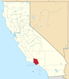 | |
| CDPs | ||
| Unincorporated communities | ||
| Footnotes | ‡This populated place also has portions in an adjacent county or counties | |
This article is issued from
Wikipedia.
The text is licensed under Creative Commons - Attribution - Sharealike.
Additional terms may apply for the media files.