| Image |
[1] |
Landmark name |
Location |
City or town |
Summary |
|---|
|
219 |
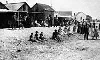
Anaheim Landing |
Seal Beach Blvd. and Electric Ave.
33°44′16″N 118°05′52″W / 33.737733°N 118.097667°W / 33.737733; -118.097667 (Anaheim Landing) |
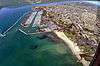
Seal Beach |
|
|
959 |
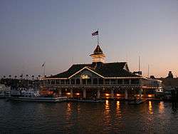
Balboa Pavilion |
400 Main St.
33°36′10″N 117°53′56″W / 33.602778°N 117.898889°W / 33.602778; -117.898889 (Balboa Pavilion) |
Newport Beach |
|
|
218 |
Barton Mound |
SE corner of I-405 and State Hwy 133
33°38′53″N 117°45′23″W / 33.648156°N 117.756509°W / 33.648156; -117.756509 (Barton Mound) |
East Irvine |
This site is unmarked. A housing development has been built on the S.E. Corner of the 405 and 133. |
|
217 |
Black Star Canyon Indian Village Site |
Ken Sampson Overview
33°45′58″N 117°40′45″W / 33.766091°N 117.679152°W / 33.766091; -117.679152 (Black Star Canyon Indian Village Site) |
Silverado |
|
 |
228 |
Carbondale |
Silverado Community Church entrance, Silverado Canyon Rd.
38°24′32″N 121°00′25″W / 38.408889°N 121.006944°W / 38.408889; -121.006944 (Carbondale) |
Silverado |
|
|
189 |
Dana Point |
Ken Sampson Overview
33°27′50″N 117°42′24″W / 33.463753°N 117.7066°W / 33.463753; -117.7066 (Dana Point) |
Dana Point |
|
|
227 |
Diego Sepúlveda Adobe |
Estancia Park
33°40′23″N 117°56′13″W / 33.673056°N 117.936944°W / 33.673056; -117.936944 (Diego Sepúlveda Adobe) |
Costa Mesa |
|
|
226 |
Don Bernardo Yorba Hacienda |
Esperanza Rd. and Echo Hill Ln.
33°51′51″N 117°46′51″W / 33.864167°N 117.780833°W / 33.864167; -117.780833 (Don Bernardo Yorba Hacienda) |
Yorba Linda |
|
|
775 |
First water-to-water flight |
S end of Main St at Ocean Front
33°35′52″N 117°53′56″W / 33.597778°N 117.898889°W / 33.597778; -117.898889 (First water-to-water flight) |
Newport Beach |
|
|
225 |
Flores Peak |
Tucker Wildlife Sanctuary
|
Modjeska Canyon |
|
|
112 |
North gate of city of Anaheim |
775 Anaheim Blvd. at North St.
33°50′38″N 117°55′01″W / 33.843983°N 117.91685°W / 33.843983; -117.91685 (North gate of city of Anaheim) |
Anaheim |
|
|
794 |
McFadden Wharf |
Newport Pier
33°36′28″N 117°55′42″W / 33.607817°N 117.928467°W / 33.607817; -117.928467 (McFadden Wharf) |
Newport Beach |
|
|
200 |
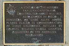
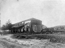
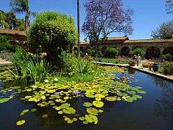
Mission San Juan Capistrano |
Ortega Hwy and Camino Capistrano
33°30′10″N 117°39′46″W / 33.502778°N 117.662778°W / 33.502778; -117.662778 (Mission San Juan Capistrano) |
San Juan Capistrano |
|
|
205 |
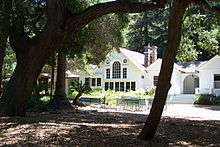
Modjeska House |
29042 Modjeska Canyon
33°42′32″N 117°37′30″W / 33.709°N 117.625°W / 33.709; -117.625 (Modjeska House) |
Modjeska |
|
|
198 |
Old Landing |
Dover Dr. north of State Hwy 1
33°37′03″N 117°54′26″W / 33.617567°N 117.907183°W / 33.617567; -117.907183 (Old Landing) |
Newport Beach |
|
|
1004 |
Old Town Irvine |
Sand Canyon Ave. and Burt Rd.
33°40′31″N 117°45′28″W / 33.675383°N 117.7578°W / 33.675383; -117.7578 (Old Town Irvine) |
Irvine |
|
|
918 |
Olinda |
Carbon Canyon Regional Park
33°55′17″N 117°49′49″W / 33.921267°N 117.8302°W / 33.921267; -117.8302 (Olinda) |
Brea |
|
|
201 |
Pioneer House of the Mother Colony |
414 N. West St.
33°50′11″N 117°55′41″W / 33.83625°N 117.9281°W / 33.83625; -117.9281 (Pioneer House of the Mother Colony) |
Anaheim |
|
|
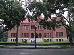
837 |
Old Orange County Courthouse |
211 W Santa Ana Blvd.
33°45′01″N 117°52′09″W / 33.750278°N 117.869167°W / 33.750278; -117.869167 (Old Orange County Courthouse) |
Santa Ana |
|
|
729 |
Old Maizeland School |
Knott's Berry Farm
|
Buena Park |
|
|
204 |
Old Santa Ana |
Lincoln Ave. & Orange Olive Rd.
33°50′12″N 117°50′47″W / 33.836667°N 117.8463°W / 33.836667; -117.8463 (Old Santa Ana) |
Orange |
|
|
203 |
Red Hill |
11911 Red Hill Rd.
33°45′26″N 117°47′32″W / 33.757117°N 117.79235°W / 33.757117; -117.79235 (Red Hill) |
Santa Ana |
|
|
1015 |
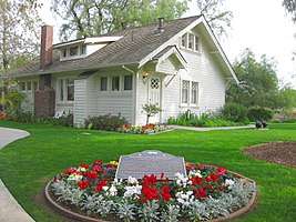
Richard Nixon Birthplace |
Richard Nixon Presidential Library and Museum
33°53′22″N 117°49′05″W / 33.889444°N 117.818056°W / 33.889444; -117.818056 (Richard Nixon Birthplace) |
Yorba Linda |
|
|
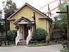
199 |
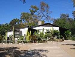
Serrano Adobe |
Serrano Regional Historic Village
33°38′30″N 117°41′07″W / 33.641667°N 117.685139°W / 33.641667; -117.685139 (Serrano Adobe) |
El Toro |
|
|
202 |
Silverado |
Historic district
33°44′46″N 117°38′10″W / 33.74611°N 117.63611°W / 33.74611; -117.63611 (Silverado) |
Silverado |
|