Busuanga, Palawan
| Busuanga | ||
|---|---|---|
| Municipality | ||
| Municipality of Busuanga | ||
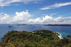 Busuanga Island | ||
| ||
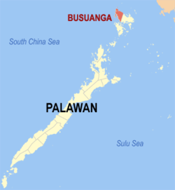 Map of Palawan with Busuanga highlighted | ||
.svg.png) Busuanga Location within the Philippines | ||
| Coordinates: 12°10′N 119°57′E / 12.17°N 119.95°ECoordinates: 12°10′N 119°57′E / 12.17°N 119.95°E | ||
| Country |
| |
| Region | Mimaropa (Region IV-B) | |
| Province | Palawan | |
| District | 1st District of Palawan | |
| Barangays | 16 (see Barangays) | |
| Government [1] | ||
| • Type | Sangguniang Bayan | |
| • Mayor | Elizabeth M. Cervantes | |
| • Vice Mayor | Elvin D. Edonga | |
| • Electorate | 13,073 voters (2016) | |
| Area [2] | ||
| • Total | 392.90 km2 (151.70 sq mi) | |
| Population (2015 census)[3] | ||
| • Total | 22,046 | |
| • Density | 56/km2 (150/sq mi) | |
| Time zone | UTC+8 (PST) | |
| ZIP code | 5317 | |
| PSGC | 175307000 | |
| IDD : area code | +63 (0)48 | |
| Climate type | Tropical climate | |
| Income class | 3rd municipal income class | |
| Revenue (₱) | 108,531,967.51 (2016) | |
| Native languages |
Calamian Tagbanwa Kagayanen Palawano language Tagalog | |

Busuanga, officially the Municipality of Busuanga, is a 3rd class municipality in the province of Palawan, Philippines. According to the 2015 census, it has a population of 22,046 people.[3]
The territory of Busuanga covers the western one-third of Busuanga Island, as well as Calauit Island, which both are part of the Calamian Islands, lying between Mindoro and Palawan Island. According to the 2015 census, it has a population of 22,046 people.[3]
The Busuanga town center, Salvacion, is approximately 50 kilometres (31 mi) from the poblacion of its neighboring municipality of Coron. Travel time is approximately two and a half to three hours by land.
Barangays
Busuanga is politically subdivided into 16 barangays.[4]
- Bogtong
- Buluang
- Cheey
- Concepcion
- Maglalambay
- New Busuanga
- New Quezon
- Old Busuanga
- Panlaitan
- Sagrada
- Salvacion (town proper)
- San Isidro
- San Rafael
- Santo Niño
- Burabod*
- Halsey*
Note: On July 15, 2002, plebiscites held in Culion and Busuanga simultaneously with the election of barangay officials and Sangguniang Kabataan representatives resulted in the ratification of the transfer of Halsey and Burabod to Culion and the creation of Barangay Carabao.
History
Oral tradition has it, that the entire island of Busuanga was once the realm of a Cuyonon datu named Datu Macanas. The island was once part of the four jurisdictions of Cuyonon datus with the other three being Datu Magbanua who reigned over Cuyo archipelago, Datu Cabaylo who had Taytay and surrounding islands and Datu Cabangon reigning over Paragua island, south of Taytay.
Busuanga was created from the barrios of Concepcion, Salvacion, Busuanga, New Busuanga, Buluang, Quezon, Calawit, and Cheey of the town of Coron in 1950.[5]
Quezon was reinstated as a barangay in 2000.[6]
Demographics
| Population census of Busuanga | |||||||||||||||||||||||||||||||||||||
|---|---|---|---|---|---|---|---|---|---|---|---|---|---|---|---|---|---|---|---|---|---|---|---|---|---|---|---|---|---|---|---|---|---|---|---|---|---|
|
| ||||||||||||||||||||||||||||||||||||
| Source: Philippine Statistics Authority[3] [7] [8] [9] | |||||||||||||||||||||||||||||||||||||
In the 2015 census, the population of Busuanga was 22,046 people,[3] with a density of 56 inhabitants per square kilometre or 150 inhabitants per square mile.
Notes
- ↑ "Municipality". Quezon City, Philippines: Department of the Interior and Local Government. Retrieved 31 May 2013.
- ↑ "Province: Palawan". PSGC Interactive. Quezon City, Philippines: Philippine Statistics Authority. Retrieved 12 November 2016.
- 1 2 3 4 5 Census of Population (2015). "Region IV-B (Mimaropa)". Total Population by Province, City, Municipality and Barangay. PSA. Retrieved 20 June 2016.
- ↑ Burabod and Halsey are not listed by PSGC making their count as 14.
- ↑ "An act to create the municipality of Busuanga in the province of Palawan". LawPH.com. Archived from the original on 2012-05-25. Retrieved 2011-04-09.
- ↑ NSCB - 2001 Factsheet - 12 New Cities Created Archived April 23, 2006, at the Wayback Machine., July–December 2000.
- ↑ Census of Population and Housing (2010). "Region IV-B (Mimaropa)". Total Population by Province, City, Municipality and Barangay. NSO. Retrieved 29 June 2016.
- ↑ Censuses of Population (1903–2007). "Region IV-B (Mimaropa)". Table 1. Population Enumerated in Various Censuses by Province/Highly Urbanized City: 1903 to 2007. NSO.
- ↑ "Province of Palawan". Municipality Population Data. Local Water Utilities Administration Research Division. Retrieved 17 December 2016.
External links
| Wikivoyage has a travel guide for Busuanga Island. |
| Wikimedia Commons has media related to Busuanga, Palawan. |
- Philippine Standard Geographic Code
- Philippine Census Information
- Local Governance Performance Management System
Places adjacent to Busuanga, Palawan | ||||||||||
|---|---|---|---|---|---|---|---|---|---|---|
| ||||||||||
Puerto Princesa (capital) | |
| Municipalities | |
| Highly urbanized city |
|