Agutaya
| Agutaya | ||
|---|---|---|
| Municipality | ||
| Municipality of Agutaya | ||
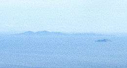
 Agutaya island, and small Oco island in the forefront | ||
| ||
 Map of Palawan with Agutaya highlighted | ||
.svg.png) Agutaya Location within the Philippines | ||
| Coordinates: 11°09′N 120°57′E / 11.15°N 120.95°ECoordinates: 11°09′N 120°57′E / 11.15°N 120.95°E | ||
| Country |
| |
| Region | Mimaropa (Region IV-B) | |
| Province | Palawan | |
| District | 1st district | |
| Barangays | 10 (see Barangays) | |
| Government [1] | ||
| • Type | Sangguniang Bayan | |
| • Electorate | 6,982 voters (2016) | |
| Area [2] | ||
| • Total | 37.31 km2 (14.41 sq mi) | |
| Population (2015 census)[3] | ||
| • Total | 12,545 | |
| • Density | 340/km2 (870/sq mi) | |
| Time zone | UTC+8 (PST) | |
| ZIP code | 5320 | |
| PSGC | 175302000 | |
| IDD : area code | +63 (0)48 | |
| Climate type | Tropical climate | |
| Income class | 5th municipal income class | |
| Revenue (₱) | 45,932,320.99 (2016) | |
| Native languages |
Agutaynen Cuyonon Palawano language Tagalog | |

Agutaya, officially the Municipality of Agutaya, is a 5th class municipality in the province of Palawan, Philippines. According to the 2015 census, it has a population of 12,545 people.[3]
An island municipality, it is the eastern part of the Cuyo Archipelago in the Sulu Sea, and the municipality covers several islands, including its namesake Agutaya Island, which is the second largest island of the Cuyo archipelago,[4] as well as Diit, Halog, Maracanao, Matarawis (also spelled Matarabis), Oco, and Quiniluban islands.
Geography
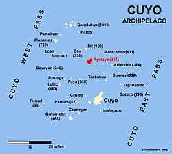
Agutaya Island is the second largest of the Cuyo group with an area of about 4.5 square miles (12 km2). The north-eastern part is hilly. Four peaks tower over the island. The middle and highest of the four peaks, 885 feet (270 m) high, is covered with cogon, the others being wooded.[4]
Native sailboats used to be unable to sail to and from the nearby island of Cuyo (only 20 miles away), due to the strength of the monsoon, either the Northwest monsoon in wintertime, or the Southwest monsoon in summer.[5]
Volcano
Agutaya is an inactive volcano, 120 metres (390 ft) ASL, located at 11°09′N 120°57′E / 11.150°N 120.950°E, in the province of Palawan in the Philippines.
Philippine Institute of Volcanology and Seismology (Phivolcs) lists Agutaya as inactive.[6]
Barangays
The Municipality of Agutaya is politically subdivided into 10 barangays.
Demographics
| Population census of Agutaya | ||||||||||||||||||||||||||||||||||||||||||||||
|---|---|---|---|---|---|---|---|---|---|---|---|---|---|---|---|---|---|---|---|---|---|---|---|---|---|---|---|---|---|---|---|---|---|---|---|---|---|---|---|---|---|---|---|---|---|---|
|
| |||||||||||||||||||||||||||||||||||||||||||||
| Source: Philippine Statistics Authority[3] [7] [8] [9] | ||||||||||||||||||||||||||||||||||||||||||||||
In the 2015 census, the population of Agutaya was 12,545 people,[3] with a density of 340 inhabitants per square kilometre or 880 inhabitants per square mile.
Languages
Agutaya is home to a specific language, called the Agutaynen language, spoken by 10,000 people overall. Today, half of its speakers live in Agutaya, while the rest live in other communities of Palawan.[10] Tagalog and Cuyonon are also widely spoken.
See also
References
- ↑ "Municipality". Quezon City, Philippines: Department of the Interior and Local Government. Retrieved 31 May 2013.
- ↑ "Province: Palawan". PSGC Interactive. Quezon City, Philippines: Philippine Statistics Authority. Retrieved 12 November 2016.
- 1 2 3 4 Census of Population (2015). "Region IV-B (Mimaropa)". Total Population by Province, City, Municipality and Barangay. PSA. Retrieved 20 June 2016.
- 1 2 United States coast pilot, Philippine islands, Vol 2 Govt. print. off., 1921 p.35
- ↑ The Gems of the East by A. Henry Savage Landor p.66
- ↑ Philippines Institute of Volcanology and Seismology (Phivolcs) List of Inactive Volcanoes Archived 2008-12-06 at the Wayback Machine.
- ↑ Census of Population and Housing (2010). "Region IV-B (Mimaropa)". Total Population by Province, City, Municipality and Barangay. NSO. Retrieved 29 June 2016.
- ↑ Censuses of Population (1903–2007). "Region IV-B (Mimaropa)". Table 1. Population Enumerated in Various Censuses by Province/Highly Urbanized City: 1903 to 2007. NSO.
- ↑ "Province of Palawan". Municipality Population Data. Local Water Utilities Administration Research Division. Retrieved 17 December 2016.
- ↑ Proceedings of the seventh International Conference on Austronesian languages by Cecilia Odé, W. A. L. Stokhof, Rijksuniversiteit te Leiden. Vakgroep Talen en Culturen van Zuidoost-Azië en Oceanië, p.685
External links
- Philippine Standard Geographic Code
- Philippine Census Information
- Local Governance Performance Management System
Places adjacent to Agutaya | |
|---|---|
Puerto Princesa (capital) | |
| Municipalities | |
| Highly urbanized city |
|