Balabac, Palawan
| Balabac Tagbariri | ||
|---|---|---|
| Municipality | ||
| Municipality of Balabac | ||
 Benlen Sandbar | ||
| ||
 Map of Palawan with Balabac highlighted | ||
.svg.png) Balabac Location within the Philippines | ||
| Coordinates: 7°59′N 117°03′E / 7.98°N 117.05°ECoordinates: 7°59′N 117°03′E / 7.98°N 117.05°E | ||
| Country |
| |
| Region | Mimaropa (Region IV-B) | |
| Province | Palawan | |
| District | 2nd district | |
| Founded | 1957 | |
| Barangays | 20 (see Barangays) | |
| Government [1] | ||
| • Type | Sangguniang Bayan | |
| • Mayor | Shuaib J. Astami | |
| • Electorate | 20,665 voters (2016) | |
| Area [2] | ||
| • Total | 581.60 km2 (224.56 sq mi) | |
| Highest elevation | 569 m (1,867 ft) | |
| Population (2015 census)[3] | ||
| • Total | 40,142 | |
| • Density | 69/km2 (180/sq mi) | |
| Time zone | UTC+8 (PST) | |
| ZIP code | 5307 | |
| PSGC | 175304000 | |
| IDD : area code | +63 (0)48 | |
| Climate type | Tropical climate | |
| Income class | 2nd municipal income class | |
| Revenue (₱) | 143,510,962.09 (2016) | |
| Native languages |
Molbog Kagayanen Palawano language Tagalog | |

Balabac, officially the Municipality of Balabac, is a 2nd class municipality in the province of Palawan, Philippines. According to the 2015 census, it has a population of 40,142 people.[3]
Balabac is known of Malaysian brands industry and some people are speaking Malay language.
The municipality consists of some 36 islands,[4] including the eponymous Balabac Island. The islands are notable for its uncommon indigenous plant and animal species, such as the nocturnal Philippine mouse-deer (or Pilandok). The islands are also home to dugongs, saltwater crocodiles, sawfishes, and sea turtles. Due to its biodiversity, the terrestrial and marine ecosystems of the Balabac archipelago are currently being pushed by scholars to be included in the tentative list of the Philippines for a possible UNESCO World Heritage Site nomination in the future.
History
Balabac was converted from a municipal district to a full-pledged municipality in 1957. Before that, it was a barrio of neighboring Bataraza.[5]
Geography
Not considering the disputed Spratly Islands, the municipality is the westernmost point in the Philippines. It is separated from Sabah, Malaysia, by the Balabac Strait.
Islands
The municipality of Balabac is composed of a group of 36 major and minor islands, notable of which are the following:
Major islands:
- Balabac (07°57′N 117°01′E / 7.950°N 117.017°E)
- Bugsuk (08°15′N 117°18′E / 8.250°N 117.300°E)
- Bancalan (08°15′N 117°06′E / 8.250°N 117.100°E)
- Mantangule (08°10′N 117°10′E / 8.167°N 117.167°E)
- Pandanan (08°17′N 117°13′E / 8.283°N 117.217°E)
- Ramos (08°06′N 117°02′E / 8.100°N 117.033°E)
Minor islands:
- Canabungan
- Candaraman
- Gabung
- Mansalangan (Byan)
- Secam
- Bowen
- Lumbucan
- South Mangsee
- North Mangsee
- Salingsingan
Shoals and Sandbars
The municipality of Balabac is composed of various islands located at the Balabac Strait. The strait is known for its shallow waters due to the presence of shoals and numerous sandbars. Balabac has the third and fourth longest sandbars in the Philippines. The third longest is Queen Helen Sandbar at the southern tip of Bugsuk and the fourth is the Angela Sandbar east of Mansalangan.[6]
Barangays
Balabac is politically subdivided into 20 barangays:
Demographics
| Population census of Balabac | ||||||||||||||||||||||||||||||||||||||||||||||
|---|---|---|---|---|---|---|---|---|---|---|---|---|---|---|---|---|---|---|---|---|---|---|---|---|---|---|---|---|---|---|---|---|---|---|---|---|---|---|---|---|---|---|---|---|---|---|
|
| |||||||||||||||||||||||||||||||||||||||||||||
| Source: Philippine Statistics Authority[3] [7] [8] [9] | ||||||||||||||||||||||||||||||||||||||||||||||
In the 2015 census, the population of Balabac was 40,142 people,[3] with a density of 69 inhabitants per square kilometre or 180 inhabitants per square mile.
Cape Melville Lighthouse
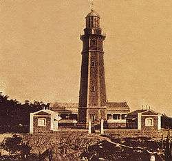
The Cape Melville Lighthouse, located on the island of Balabac, is one of the Philippines oldest lighthouses built in 1892[10] during the Spanish era and a major landmark of the town.
Transportation
Transportation link to the town of Balabac can be done through the town of Bataraza from the main capital Puerto Princesa. From Rio Tuba, in Bataraza, a three-hour boat ride takes a traveler to the main island of Balabac where the town proper is located. Travel to other barangays in the municipality is done through boat rides.
An old airstrip located in the island of Bugsuk does not operate commercial flights. Another private airstrip is located in the island of Ramos.
References
- ↑ "Municipality". Quezon City, Philippines: Department of the Interior and Local Government. Retrieved 31 May 2013.
- ↑ "Province: Palawan". PSGC Interactive. Quezon City, Philippines: Philippine Statistics Authority. Retrieved 12 November 2016.
- 1 2 3 4 Census of Population (2015). "Region IV-B (Mimaropa)". Total Population by Province, City, Municipality and Barangay. PSA. Retrieved 20 June 2016.
- ↑ http://www.mb.com.ph/at-the-tip-of-the-last-frontier/
- ↑ "R.A. No. 2022, An Act Converting the Municipal District of Balabac, Province of Palawan, into a Regular Municipality". LawPH.com. Archived from the original on 2012-07-10. Retrieved 2011-04-13.
- ↑ Malicdem, Ervin (12 July 2017). "10 Longest Sandbars of the Philippines". Schadow1 Expeditions. Retrieved 29 October 2017.
- ↑ Census of Population and Housing (2010). "Region IV-B (Mimaropa)". Total Population by Province, City, Municipality and Barangay. NSO. Retrieved 29 June 2016.
- ↑ Censuses of Population (1903–2007). "Region IV-B (Mimaropa)". Table 1. Population Enumerated in Various Censuses by Province/Highly Urbanized City: 1903 to 2007. NSO.
- ↑ "Province of Palawan". Municipality Population Data. Local Water Utilities Administration Research Division. Retrieved 17 December 2016.
- ↑ https://anc.yahoo.com/news/palawan-lighthouse-needs-to-be--rescued-122234621.html
External links
| Wikimedia Commons has media related to Balabac, Palawan. |
- Philippine Standard Geographic Code
- Philippine Census Information
- Local Governance Performance Management System
Places adjacent to Balabac, Palawan | ||||||||||
|---|---|---|---|---|---|---|---|---|---|---|
| ||||||||||
Puerto Princesa (capital) | |
| Municipalities | |
| Highly urbanized city |
|