Dumaran
| Dumaran | ||
|---|---|---|
| Municipality | ||
| Municipality of Dumaran | ||
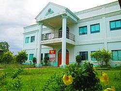 Municipal Hall | ||
| ||
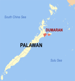 Map of Palawan with Dumaran highlighted | ||
.svg.png) Dumaran Location within the Philippines | ||
| Coordinates: 10°32′N 119°46′E / 10.53°N 119.77°ECoordinates: 10°32′N 119°46′E / 10.53°N 119.77°E | ||
| Country |
| |
| Region | Mimaropa (Region IV-B) | |
| Province | Palawan | |
| District | 1st district | |
| Barangays | 16 (see Barangays) | |
| Government [1] | ||
| • Type | Sangguniang Bayan | |
| • Mayor | Medwin C. Pablico | |
| • Electorate | 11,660 voters (2016) | |
| Area [2] | ||
| • Total | 435.00 km2 (167.95 sq mi) | |
| Population (2015 census)[3] | ||
| • Total | 23,734 | |
| • Density | 55/km2 (140/sq mi) | |
| Time zone | UTC+8 (PST) | |
| ZIP code | 5310 | |
| PSGC | 175311000 | |
| IDD : area code | +63 (0)48 | |
| Climate type | Tropical climate | |
| Income class | 3rd municipal income class | |
| Revenue (₱) | 113,768,656.38 (2016) | |
| Native languages |
Palawano language Tagalog | |

Dumaran, officially the Municipality of Dumaran, is a 3rd class municipality in the province of Palawan, Philippines. According to the 2015 census, it has a population of 23,734 people.[3]
The municipality covers the southern part of the namesake Dumaran Island (where the poblacion is located), as well as a portion on Palawan Island. It is bounded on the north-east by Municipality of Araceli, on the south by Sulu Sea, on the south-west by Roxas, and on the north-west by the municipality of Taytay. Dumaran also celebrate the Kalabukay Festival - Kalabukay refers to a local bird that is common to the people of Dumaran. The Municipality of Dumaran is in rich with natural resources. The majority of the people living in Dumaran are farmer and fisherman.
Barangays
Dumaran is politically subdivided into 16 barangays, 9 barangays on the mainland of Palawan, and 7 barangays on Dumaran Island.
- Bacao (island)
- Bohol (island)
- Calasag (island)
- Capayas (mainland)
- Catep (island)
- Culasian (mainland)
- Danleg (mainland)
- Dumaran (Poblacion, island)
- Itangil (mainland)
- Ilian (mainland)
- Magsaysay (mainland)
- San Juan (island)
- Santa Teresita (mainland)
- Santo Tomas (island)
- Tanatanaon (mainland)
- Santa Maria (mainland)
Demographics
| Population census of Dumaran | |||||||||||||||||||||||||||||||||||||||||||
|---|---|---|---|---|---|---|---|---|---|---|---|---|---|---|---|---|---|---|---|---|---|---|---|---|---|---|---|---|---|---|---|---|---|---|---|---|---|---|---|---|---|---|---|
|
| ||||||||||||||||||||||||||||||||||||||||||
| Source: Philippine Statistics Authority[3] [4] [5] [6] | |||||||||||||||||||||||||||||||||||||||||||
In the 2015 census, the population of Dumaran was 23,734 people,[3] with a density of 55 inhabitants per square kilometre or 140 inhabitants per square mile.
The dominant language is Cuyonon, while Bisaya and Tagalog are spoken as secondary languages.
Culture
In relation to its foundation day June 14, Dumaran celebrates Kalabukay Festival annually from June 14–18.
References
- ↑ "Municipality". Quezon City, Philippines: Department of the Interior and Local Government. Retrieved 31 May 2013.
- ↑ "Province: Palawan". PSGC Interactive. Quezon City, Philippines: Philippine Statistics Authority. Retrieved 12 November 2016.
- 1 2 3 4 Census of Population (2015). "Region IV-B (Mimaropa)". Total Population by Province, City, Municipality and Barangay. PSA. Retrieved 20 June 2016.
- ↑ Census of Population and Housing (2010). "Region IV-B (Mimaropa)". Total Population by Province, City, Municipality and Barangay. NSO. Retrieved 29 June 2016.
- ↑ Censuses of Population (1903–2007). "Region IV-B (Mimaropa)". Table 1. Population Enumerated in Various Censuses by Province/Highly Urbanized City: 1903 to 2007. NSO.
- ↑ "Province of Palawan". Municipality Population Data. Local Water Utilities Administration Research Division. Retrieved 17 December 2016.
External links
| Wikimedia Commons has media related to Dumaran. |
- Philippine Standard Geographic Code
- Philippine Census Information
- Local Governance Performance Management System
Puerto Princesa (capital) | |
| Municipalities | |
| Highly urbanized city |
|