Narra, Palawan
| Narra | |
|---|---|
| Municipality | |
| Municipality of Narra | |
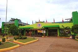 Municipal Hall | |
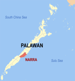 Map of Palawan with Narra highlighted | |
.svg.png) Narra Location within the Philippines | |
| Coordinates: 9°17′N 118°25′E / 9.28°N 118.42°ECoordinates: 9°17′N 118°25′E / 9.28°N 118.42°E | |
| Country |
|
| Region | Mimaropa (Region IV-B) |
| Province | Palawan |
| District | 2nd district |
| Founded | June 21, 1969 |
| Barangays | 23 (see Barangays) |
| Government [1] | |
| • Type | Sangguniang Bayan |
| • Mayor | Lucena D. Demaala |
| • Electorate | 37,697 voters (2016) |
| Area [2] | |
| • Total | 831.73 km2 (321.13 sq mi) |
| Population (2015 census)[3] | |
| • Total | 73,212 |
| • Density | 88/km2 (230/sq mi) |
| Time zone | UTC+8 (PST) |
| ZIP code | 5319 |
| PSGC | 175315000 |
| IDD : area code | +63 (0)48 |
| Climate type | Tropical climate |
| Income class | 1st municipal income class |
| Revenue (₱) | 254,372,291.52 (2016) |
| Native languages |
Palawano language Tagalog |
Narra, officially the Municipality of Narra, is a 1st class municipality in the province of Palawan, Philippines. According to the 2015 census, it has a population of 73,212 people.[3]
Besides spelling out the local name for the Pterocarpus indicus—the Philippines' national tree—it is an acronym for National Resettlement Rehabilitation Administration. This program, established on June 18, 1954, resettled landless people from Luzon to Palawan. On June 21, 1969, the Municipality of Narra was created by virtue of Republic Act No. 5642 signed by President Ferdinand Marcos.[4]
Having a title as "The Rice Granary of Palawan" Municipality of Narra is the main rice producer of the Province of Palawan. The municipality also held "Palay Festival" (Formerly called as "Anihan(Reaping) Festival") held every middle or end week of the October.
Narra also includes Rasa Island, home of the endangered endemic cockatoo species called "Katala or Abukay or Kalangay (depends on local dialect)" or Philippine red-vented cockatoo (cacatua haematuropygia) and other rare animal species.
Barangays
Narra is politically subdivided into 23 barangays.
- Antipuluan
- Aramaywan
- Batang-batang
- Bato-bato (San Isidro)
- Burirao
- Caguisan
- Calategas
- Dumagueña
- Elvita
- Estrella Village
- Ipilan
- Malatgao
- Malinao
- Narra (Poblacion)
- Panacan
- Panacan 2
- Princess Urduja
- Sandoval
- Tacras
- Taritien
- Teresa
- Tinagong Dagat
- Bagong Sikat
Demographics
| Population census of Narra | ||||||||||||||||||||||||||||||||||
|---|---|---|---|---|---|---|---|---|---|---|---|---|---|---|---|---|---|---|---|---|---|---|---|---|---|---|---|---|---|---|---|---|---|---|
|
| |||||||||||||||||||||||||||||||||
| Source: Philippine Statistics Authority[3][5][6][7] | ||||||||||||||||||||||||||||||||||
In the 2015 census, the population of Narra, Palawan, was 73,212 people,[3] with a density of 88 inhabitants per square kilometre or 230 inhabitants per square mile.
Gallery
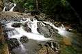 Estrella Falls
 Malatgao Beach
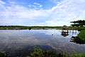 Fish Pond in Malatgao
- Narra Municipal Hall
References
- ↑ "Municipality". Quezon City, Philippines: Department of the Interior and Local Government. Retrieved 31 May 2013.
- ↑ "Province: Palawan". PSGC Interactive. Quezon City, Philippines: Philippine Statistics Authority. Retrieved 12 November 2016.
- 1 2 3 4 Census of Population (2015). "Region IV-B (Mimaropa)". Total Population by Province, City, Municipality and Barangay. PSA. Retrieved 20 June 2016.
- ↑ "NARRA" (PDF). Provincial Government of Palawan. Archived from the original (PDF) on 4 March 2012. Retrieved 22 November 2012.
- ↑ Census of Population and Housing (2010). "Region IV-B (Mimaropa)". Total Population by Province, City, Municipality and Barangay. NSO. Retrieved 29 June 2016.
- ↑ Censuses of Population (1903–2007). "Region IV-B (Mimaropa)". Table 1. Population Enumerated in Various Censuses by Province/Highly Urbanized City: 1903 to 2007. NSO.
- ↑ "Province of Palawan". Municipality Population Data. Local Water Utilities Administration Research Division. Retrieved 17 December 2016.
External links
- Philippine Standard Geographic Code
- Philippine Census Information
- Local Governance Performance Management System
Places adjacent to Narra, Palawan | |
|---|---|
Puerto Princesa (capital) | |
| Municipalities | |
| Highly urbanized city |
|