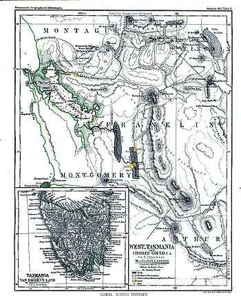
West Coast, Tasmania
The West Coast of Tasmania is the part of the state that is strongly associated with wilderness, mining and tourism, rough country and isolation. As well as that, it was an early convict settlement location in the early stages of Van Diemen's Land.
As a consequence of the images of the region and its attributes, it is regularly considered "outside" the tamed and agriculturally developed eastern side of the island of Tasmania.
The separation from the south west region, is that the south west has never had roads or other technical links back to the east coast. The west coast has been mined, it has had railways penetrate, and roads and power lines move through the landscape, it has been entered, but in many locations - where mines or other activities have closed, or settlements become abandoned, vegetation and time have in many cases hidden the locations.
Climate
The west coast has a much cooler and wetter climate when compared to the east coast. Frequent low pressure systems hit the west coast causing heavy rain, snow, and ice. The West Coast Range blocks these systems from impacting the east, therefore making the West Coast a rain catchment with some areas receiving over 2,000 millimetres (79 in) of rain a year. In winter temperatures at sea level hover around 10 °C (50 °F), and when not raining, morning frost is common. The temperatures are much lower inland from the coast with maximums in winter often failing to surpass 0 °C (32 °F). Typically, the snow line in winter is around 900 metres (3000 ft), however sea level snow falls several times each winter as well. Summer is mild with maximum temperatures averaging between 17 °C (63 °F) and 21 °C (70 °F), though some days still fail to reach 10 °C (50 °F). Despite snowfall usually occurring in winter, it has been known to fall in the middle of summer.[1]
The ethos
Many outsiders have had difficulty understanding the isolation of the west coast, and the small communities, and the historical context to that isolation. Initially the only way in and out was by sea, and no serviceable roads to either the north or east existed until the 1930s (east) or the 1960s (north). Railways were the main land connection from the 1920s to the 1960s - though that connection was with the north coast, rather than the more populous southeast.[2]
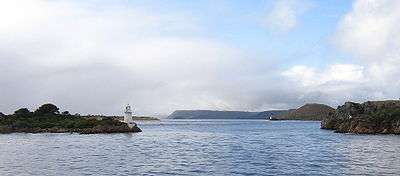
The treacherous conditions at Hell's Gates at the mouth of Macquarie Harbour, and ocean travel along the exposed western side of Tasmania have made marine travel a dangerous pastime even to the current day, despite modern technology. Memorial plaques to recent lost sailors on the wall at the northern edge of the Strahan wharf illustrate this.
The current airstrip is at Strahan, with the airstrip at Queenstown no longer a current registered landing ground.[3] In the 1970s a regular service to the east coast was run by Airlines of Tasmania.
All transport services to the west coast are subject to interruption by severe weather. In addition to closures of air and marine service, the roads to the west coast may be blocked for days at a time by ice and snow during severe winter conditions.
The consequence of the isolation, and the ways that the communities coped with the difficulties, were little examined prior to the 1990s, except for parts of Tim Bowden's 1979 Radio Documentary "The West Coasters", and various references in Geoffrey Blainey's "The Peaks of Lyell" book and the important works of C.J. Binks [4] and Kerry Pink.[5]
Since the rise of tourism on the west coast, the Franklin Dam issue and the creation of the world heritage wilderness area, a steady number of small publications concerning the history and features of the region have been produced.
For a brief time in the early 20th century the west coast had population and political power on a parity with Hobart and Launceston. Following the demise of most of the Zeehan mines, the west coast population has either remained static, or declined relative to other parts of the island.
The legacy
The environment is described with particular historical understanding by C.J. Binks in "Explorers of Western Tasmania" Chapter 2 - "A Sketch of the Western Country". See also West Coast Range
The convict era is introduced in articles about Macquarie Harbour Penal Station, Convicts on the West Coast of Tasmania, and Hell's Gates.
The reliance on the railways can be found in the separate article West Coast Tasmania Railways.
The mining history was captured first in Charles Whitham's Western Tasmania book - and Geoffrey Blainey's Peaks of Lyell and the books that have followed. See also the list at West Coast Tasmania Mines for a list that includes historical names and locations - many now long abandoned.
The vast tracts of forest (Huon Pine, among others) in the west coast region have been subject to fire, and exploitation - as well as significant areas now under conservation. The history of the West Coast Piners who utilised the Franklin River and Gordon River and their tributaries is a vital part of west coast history.
The legacy of the Hydro Electric Commission (The Hydro) on the west coast is a complex one, due to its sense in the 1940s to 1980s considering the west and south west regions as its 'last frontier' for the remaining catchments for its power development schemes.
Photographic record
As most of the European activity on the west coast (after the convict era) lies within the invention and use of the camera, most aspects of west coast history have been captured on film.
The Queen Victoria Museum and Art Gallery, and the State Library of Tasmania in Hobart are the main holdings of the record, while the late Eric Thomas's collection in the 'Galley Museum' in Queenstown is on a par with both.
Some examples of collections: -
- Hurley, Frank. Tasmania, A Camera Study John Sands, 1953
- Cox, G.W. and Ratcliff, E.V.R. Tasmania Remembered ( H.J. King ) Mary Fisher Bookshop, 1974. ISBN 0-9599207-2-2
- Tassell, M. and Wood, D. Tasmanian Photographer (John Watt Beattie) Macmillan, 1981. ISBN 0-333-33737-9
- Hopkins, D.L. The Golden Years of Tasmania St David's Park, 1991. ISBN 0-7246-2536-4
- Morley, Les. The way we were The Author, 1997. Third Edition.
Due to the rise of tourism in the 1990s - a considerable number of DVDs and videos are commercially available of the region - going into areas which had been inaccessible as recently as 30 or 40 years ago. Also tourists and hikers have gathered a considerable record of the region which regularly appears in either their own or generally accessible websites on the internet.
Bioregion
The Tasmanian West bioregion comprises the West Coast region and the South West region.[6]
See also
References
- ↑ "Climate of Tasmania". Bureau of Meteorology. Archived from the original on 17 March 2009. Retrieved 22 August 2011.
- ↑ See - Railways on the West Coast of Tasmania
- ↑ Photograph - Aero Club of Southern Tasmania pilots and aircraft on Queenstown Air Strip - Mt Owen in background, LINC Tasmania, retrieved 23 February 2015
- ↑ http://trove.nla.gov.au/people/617762?q=creator%3A%22Binks%2C+C.+J%22&c=people
- ↑ http://trove.nla.gov.au/people/554087?q=creator%3A%22Pink%2C+Kerry.%22&c=people
- ↑ "Interim Biogeographic Regionalisation for Australia (IBRA7) regions and codes". Department of Sustainability, Environment, Water, Population and Communities. Australian Government. 2012. Retrieved 13 January 2013.
Bibliography
- Binks, C.J. (1980). Explorers of Western Tasmania. Launceston: Mary Fisher Bookshop. ISBN 0-908291-16-7.
- Blainey, Geoffrey (2000). The Peaks of Lyell (6th ed.). Hobart: St. David's Park Publishing. ISBN 0-7246-2265-9.
- Tuma, Andrew and Bottrill, R.S.(2006) The minerals of Western Tasmania:Introduction, history and geological setting in Australian Journal of Mineralogy, volume 12, No.2, December 2006 pp. 51–58
- Whitham, Charles (2003). Western Tasmania - A land of riches and beauty (Reprint 2003 ed.). Queenstown: Municipality of Queenstown.
- Whitham, Lindsay (2002). Railways, Mines, Pubs and People and other historical research. Sandy Bay: Tasmanian Historical Research Association. ISBN 0-909479-21-6.
- Stoddart, D.Michael, ed. (1993). Walk to the West. Hobart: The Royal Society of Tasmania. ISBN 0-9598679-9-6.
External links
| Wikimedia Commons has media related to Tasmania. |
| Wikivoyage has a travel guide for West Coast, Tasmania. |
- http://www.parks.tas.gov.au/wha/wherein/detail.html - context in position to World Heritage Area
| General |
| |
|---|---|---|
| Regions |
| |
| Cities | ||
Tasmania portal | ||