Burnaby
| Burnaby | |||||
|---|---|---|---|---|---|
| City | |||||
| City of Burnaby | |||||
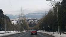
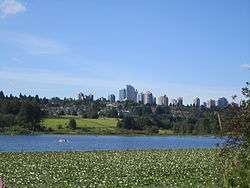 Metrotown area, seen from Burnaby's Deer Lake | |||||
| |||||
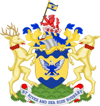
| Motto(s): By River and Sea Rise Burnaby | |||||
 | |||||
| Coordinates: 49°16′N 122°58′W / 49.267°N 122.967°WCoordinates: 49°16′N 122°58′W / 49.267°N 122.967°W | |||||
| Country | Canada | ||||
| Province | British Columbia | ||||
| Regional District | Metro Vancouver | ||||
| Established | 1892 (municipality status) | ||||
| – | 1992 (city status) | ||||
| Government | |||||
| • Mayor | Derek Corrigan | ||||
| • MP |
List of MPs
| ||||
| • MLA |
List of MLAs
| ||||
| Area | |||||
| • Total | 98.60 km2 (38.07 sq mi) | ||||
| Elevation | Sea level to 370 m (0–1,214 ft) | ||||
| Population (2016)[1] | |||||
| • Total | 232,755 (ranked 22nd) | ||||
| • Density | 2,568.7/km2 (6,653/sq mi) | ||||
| Time zone | UTC-8 (Pacific Standard (PST)) | ||||
| • Summer (DST) | UTC-7 (Pacific Daylight (PDT)) | ||||
| Forward sortation area | V3N, V5A - V5J | ||||
| Area code(s) | 604, 778 | ||||
| Highways |
| ||||
| Website | www.burnaby.ca | ||||
Burnaby is a city in British Columbia, Canada, located immediately to the east of Vancouver. It is the third-largest city in British Columbia by population, surpassed only by nearby Surrey and Vancouver.
Burnaby was incorporated in 1892 and achieved City status in 1992, one hundred years after incorporation. It is the seat of Metro Vancouver's regional government.
History
At incorporation, the municipality's citizens unanimously chose to name it after the legislator, speaker, Freemason and explorer Robert Burnaby, who had been private secretary to Colonel Richard Moody, the first land commissioner for the Colony of British Columbia, in the mid-19th century.[2] In 1859 Burnaby had surveyed the freshwater lake near what is now the city's geographical centre. Moody chose to name it Burnaby Lake.
In the first 30 to 40 years after its incorporation, the growth of Burnaby was influenced by its location between the expanding urban centres of Vancouver and New Westminster. It first served as a rural agricultural area supplying nearby markets. Later, it served as an important transportation corridor between Vancouver, the Fraser Valley and the Interior, and continues to do so.
As Vancouver expanded and became a metropolis, Burnaby was one of the first-tier bedroom-community suburbs of Vancouver itself, along with the city and district of North Vancouver, and Richmond. During the suburbanization of Burnaby, "Mid-Century Vernacular" homes were built by the hundreds to cope with population increase, and these houses are still very common in the city. Burnaby has shifted in character over time from rural to suburban to urban.
Geography and land use
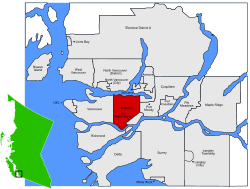
Burnaby occupies 98.60 square kilometres (38.07 sq mi) and is located at the geographical centre of the Metro Vancouver area. Situated between the city of Vancouver on the west and Port Moody, Coquitlam, and New Westminster on the east, Burnaby is further bounded by Burrard Inlet and the Fraser River on the north and south respectively. Burnaby, Vancouver and New Westminster collectively occupy the major portion of the Burrard Peninsula. The elevation of Burnaby ranges from sea level to a maximum of 370 metres (1,200 ft) atop Burnaby Mountain. Due to its elevation, the city of Burnaby experiences quite a bit more snowfall during the winter months than nearby Vancouver or Richmond. Overall, the physical landscape of Burnaby is one of hills, ridges, valleys and an alluvial plain. The land features and their relative locations have had an influence on the location, type and form of development in the city.
Burnaby is home to many industrial and commercial firms. British Columbia's largest (and Canada's second largest) commercial mall, the Metropolis at Metrotown, is located in Burnaby. Still, Burnaby's ratio of park land to residents is one of the highest in North America, and it maintains some agricultural land, particularly along the Fraser foreshore flats in the Big Bend neighbourhood along its southern perimeter.
Burnaby parks, rivers, and lakes
Major parklands and waterways in Burnaby include Central Park, Robert Burnaby Park, Kensington Park, Burnaby Mountain, Still Creek, the Brunette River, Burnaby Lake, Deer Lake, and Squint Lake.
Climate
Given that the Simon Fraser University weather station is located 365 meters above sea level on Burnaby Mountain, the climate shown is significantly cooler and wetter as compared to the rest of the city.
| Climate data for Burnaby (Simon Fraser University) 1981−2010 at 365 metres | |||||||||||||
|---|---|---|---|---|---|---|---|---|---|---|---|---|---|
| Month | Jan | Feb | Mar | Apr | May | Jun | Jul | Aug | Sep | Oct | Nov | Dec | Year |
| Record high °C (°F) | 16.5 (61.7) |
18.5 (65.3) |
23.0 (73.4) |
28.0 (82.4) |
33.0 (91.4) |
31.1 (88) |
34.0 (93.2) |
33.9 (93) |
34.5 (94.1) |
26.5 (79.7) |
19.4 (66.9) |
16.1 (61) |
34.5 (94.1) |
| Average high °C (°F) | 5.8 (42.4) |
6.8 (44.2) |
9.3 (48.7) |
12.4 (54.3) |
15.6 (60.1) |
18.2 (64.8) |
21.2 (70.2) |
21.2 (70.2) |
18.0 (64.4) |
12.0 (53.6) |
7.5 (45.5) |
5.1 (41.2) |
12.7 (54.9) |
| Daily mean °C (°F) | 3.6 (38.5) |
4.3 (39.7) |
6.2 (43.2) |
8.7 (47.7) |
11.8 (53.2) |
14.4 (57.9) |
17.0 (62.6) |
17.2 (63) |
14.6 (58.3) |
9.5 (49.1) |
5.3 (41.5) |
2.9 (37.2) |
9.6 (49.3) |
| Average low °C (°F) | 1.4 (34.5) |
1.7 (35.1) |
3.1 (37.6) |
4.9 (40.8) |
7.9 (46.2) |
10.5 (50.9) |
12.7 (54.9) |
13.2 (55.8) |
11.1 (52) |
7.0 (44.6) |
3.0 (37.4) |
0.8 (33.4) |
6.5 (43.7) |
| Record low °C (°F) | −13.9 (7) |
−14 (7) |
−8 (18) |
−3.3 (26.1) |
−0.5 (31.1) |
3.9 (39) |
5.0 (41) |
3.3 (37.9) |
2.0 (35.6) |
−7 (19) |
−14 (7) |
−19.4 (−2.9) |
−19.4 (−2.9) |
| Average precipitation mm (inches) | 280.9 (11.059) |
178.4 (7.024) |
182.1 (7.169) |
154.4 (6.079) |
120.0 (4.724) |
101.4 (3.992) |
64.7 (2.547) |
64.5 (2.539) |
92.2 (3.63) |
210.1 (8.272) |
311.6 (12.268) |
249.8 (9.835) |
2,009.9 (79.13) |
| Average rainfall mm (inches) | 256.5 (10.098) |
163.2 (6.425) |
171.2 (6.74) |
152.7 (6.012) |
119.9 (4.72) |
101.4 (3.992) |
64.7 (2.547) |
64.5 (2.539) |
92.2 (3.63) |
209.8 (8.26) |
303.6 (11.953) |
220.8 (8.693) |
1,920.7 (75.618) |
| Average snowfall cm (inches) | 24.3 (9.57) |
15.1 (5.94) |
10.9 (4.29) |
1.7 (0.67) |
0.1 (0.04) |
0.0 (0) |
0.0 (0) |
0.0 (0) |
0.0 (0) |
0.2 (0.08) |
8.0 (3.15) |
29.0 (11.42) |
89.3 (35.16) |
| Average precipitation days (≥ 0.2 mm) | 20.5 | 16.2 | 18.9 | 16.1 | 14.9 | 13.5 | 7.4 | 6.8 | 10.3 | 17.1 | 21.6 | 19.8 | 183.1 |
| Average rainy days (≥ 0.2 mm) | 18.1 | 14.7 | 18.3 | 16.0 | 14.9 | 13.5 | 7.4 | 6.8 | 10.3 | 17.0 | 21.0 | 17.3 | 175.4 |
| Average snowy days (≥ 0.2 cm) | 4.0 | 2.5 | 2.0 | 0.54 | 0.04 | 0.0 | 0.0 | 0.0 | 0.0 | 0.09 | 1.8 | 4.5 | 15.5 |
| Source: Environment Canada[3] | |||||||||||||
Transportation
The SkyTrain rapid transit system, based in Burnaby, crosses the city from east to west in two places: the Expo Line (completed in 1986) crosses the south along Kingsway and the Millennium Line (completed in 2002) follows Lougheed Highway. The SkyTrain has encouraged closer connections to New Westminster, Vancouver, and Surrey, as well as dense urban development at Lougheed Town Centre on the city's eastern border, at Brentwood Town Centre in the centre-west and, most notably, at Metrotown in the south.
Major north-south streets crossing the City include Boundary Road, Willingdon Avenue, Royal Oak Avenue, Kensington Avenue, Sperling Avenue, Gaglardi Way, Cariboo Road, and North Road. East-west routes linking Burnaby's neighbouring cities to each other include Hastings Street, Barnet Highway, the Lougheed Highway, Kingsway (which follows the old horse trail between Vancouver and New Westminster), Canada Way and Marine Drive/Marine Way. Douglas Road, which used to cross the city from northwest to southeast, has largely been absorbed by the Trans-Canada Highway and Canada Way. Since the 1990s, Burnaby has developed a network of cycling trails. It is also well served by Metro Vancouver's bus system, run by the Coast Mountain Bus Company, a division of TransLink.
Demographics
According to the 2011 Census, Statistics Canada reported that Burnaby had a population of 223,218 who resided in 86,839 of its 91,383 total dwellings, a 10.1% change from the 2006 census.[4] With a land area of 90.61 km2 (34.98 sq mi), it had a population density of 2,463.5/km2 (6,380.4/sq mi) in 2011. The median age is 39.8 years old, slightly younger than the British Columbia median of 41.9 years old.[5]
| Canada 2016 Census | Population | % of Total Population | |
|---|---|---|---|
| Visible minority group Source:[6] | |||
| South Asian | 18,735 | 8.1% | |
| Chinese | 78,025 | 33.9% | |
| Black | 3,670 | 1.6% | |
| Filipino | 13,000 | 5.7% | |
| Latin American | 4,630 | 2% | |
| Arab | 1,700 | 0.7% | |
| Southeast Asian | 4,620 | 2% | |
| West Asian | 4,960 | 2.2% | |
| Korean | 7,790 | 3.4% | |
| Japanese | 3,655 | 1.6% | |
| Other visible minority | 690 | 0.3% | |
| Mixed visible minority | 4,840 | 2.1% | |
| Total visible minority population | 146,310 | 63.6% | |
| Aboriginal group Source:[7] | |||
| First Nations | 2,615 | 1.1% | |
| Métis | 1,365 | 0.6% | |
| Other Aboriginal groups | 225 | 0.1% | |
| Total Aboriginal population | 4,195 | 1.8% | |
| European Canadian | 79,575 | 34.6% | |
| Total population | 230,080 | 100% | |
Religion
Burnaby's religious profile:[8]
- 41.6% No religious affiliation
- 42.9% Christian
- 4.8% Buddhist
- 4.5% Muslim
- 2.9% Sikh
- 2.2% Hindu
- 0.3% Jewish
- 0.8% Other religions
| Historical populations | ||
|---|---|---|
| Year | Pop. | ±% |
| 2001 | 193,954 | — |
| 2006 | 202,799 | +4.6% |
| 2011 | 223,218 | +10.1% |
| 2016 | 232,755 | +4.3% |
People and politics
While Burnaby occupies about 4% of the land area of the Greater Vancouver Regional District, it accounted for about 10% of the region's population in 2001. It is the third most populated urban centre in British Columbia (after Vancouver and Surrey) with an estimated population of 205,261. Like much of Greater Vancouver, Burnaby has always had large ethnic and immigrant communities: to cite two examples, North Burnaby near Hastings Street has long been home to many Italian restaurants and recreational bocce games, while Metrotown's ever-sprouting condominium towers in the south have been fuelled in part by more recent arrivals from China (Hong Kong and Macau), Taiwan, and South Korea. According to the 2006 Census, 54% of Burnaby residents have a mother tongue that is neither English nor French.
Politically, Burnaby has maintained a left-wing city council closely affiliated with the provincial NDP and school board for many years, while sometimes electing more conservative legislators provincially (for the Social Credit and BC Liberal parties) and federally (for the Reform, Alliance, and Conservative parties). Its longest-serving politician had been Svend Robinson of the New Democratic Party (NDP), Canada's first openly gay member of Parliament, but after 25 years and seven elections he resigned his post in early 2004 after stealing and then returning an expensive ring. Burnaby voters endorsed his assistant, Bill Siksay, as his replacement in the spring 2004 Canadian federal election. In the May 2013 provincial election, residents of the city sent 3 NDP MLAs and one Liberal MLA to the British Columbia legislature. The NDP MLA for Burnaby-Lougheed, Jane Shin, faced controversy after the election for misrepresenting herself as a physician while not having completed a medical residency nor holding a license to practise medicine.[9]
According to a 2009 survey by Maclean's magazine, Burnaby is Canada's best run city. The survey looks at a city's efficiency, the cost of producing results, and the effectiveness of its city services.[10] However, Maclean's does note that Burnaby has one of the worst municipal voter turnouts in the country, 26 per cent. In 2015, the Canadian Federation of Independent Business (CFIB) included Burnaby as a Vancouver periphery to rank eighth for entrepreneurial communities.[11]
Industry and economy

Major technology firms such as Electronic Arts, Creo (now part of Eastman Kodak), Ballard Power Systems and Telus base their operations in Burnaby; heavy industry includes Chevron Corporation and Petro-Canada petroleum refineries on the shores of Burrard Inlet. Other companies such as eBay (ceased operation in 2009),[12] Future Shop, Ritchie Bros. Auctioneers, Pacific Blue Cross and Nokia have significant facilities in Burnaby as well. Other firms with operations based in Burnaby include Canada Wide Media, Doteasy, Telus, Teradici, AFCC, Mercedes-Benz Fuel Cell, HSBC Group Systems Development Center, and TransLink. The city features high density residential areas, major commercial town centres, rapid transit, high technology research and business parks, film production studios such as The Bridge Studios, TV stations such as Global TV and comprehensive industrial estates.
Sports
Burnaby has a velodrome, the Burnaby Velodrome. The city's main stadium, Swangard Stadium, is located in Central Park.
Education
School District 41 is responsible for the public schools in Burnaby. It also has a Community and Adult Education Department, and also an International Students' Programme. Major post-secondary institutions include the main campuses of Simon Fraser University (atop Burnaby Mountain) and the British Columbia Institute of Technology.
Schools in Burnaby, British Columbia | ||
|---|---|---|
| Secondary schools | ||
| Primary or elementary schools |
| |
| Private schools |
| |
| Other schools |
| |
Culture
Burnaby South Secondary School features the Michael J. Fox Theatre, a community theatre that seats 613 with 11 wheelchair spaces.
Many cultural facilities are located in or around Deer Lake Park, including the Burnaby Art Gallery, Shadbolt Centre for the Arts, and the Burnaby Village Museum, an open-air museum of a 1920s Canadian village.
Notable people

- Karl Alzner, NHL hockey player
- Andrea Bang, Actor best known for Kim's Convenience (TV series)
- Diana Bang, Actor best known for The Interview
- Glenn Anderson, NHL hockey player
- Michael Bublé, singer
- Christy Clark, former Premier of British Columbia
- Kris Chucko, NHL hockey player
- Ian James Corlett, voice actor, writer, and TV producer
- Robin Esrock, South-African-born Canadian travel writer, TV host and author
- Michael J. Fox, Canadian-American actor
- Kaleigh Fratkin (born 1992), professional ice hockey player
- Jacob Hoggard, lead singer of Hedley
- Joe Keithley, musician and political activist
- Eagle Keys, American-born CFL football player and head coach
- Jason LaBarbera, NHL hockey player
- Brad Loree, movie stuntman
- Kenndal McArdle, former NHL hockey player and investment banker
- John H. McArthur, Harvard Business School dean
- Darren McCarty, NHL hockey player
- Carrie-Anne Moss, movie, television and voice actress
- Dave Nonis, former Senior Vice President and Director of Hockey Operations of the Toronto Maple Leafs
- Ryan Nugent-Hopkins, NHL hockey player
- Mark Olver, NHL and KHL hockey Player
- Tyler O'Neill, MLB player for the St. Louis Cardinals
- Buzz Parsons, NASL soccer player and later CSL coach
- Dugald Campbell Patterson, Scottish-born Burnaby pioneer
- Dick Phillips, American-born MLB baseball player and PCL team manager
- Roy Radu, Rugby union player
- Svend Robinson, former federal MP, arbitrator/advocate and parliamentary relations consultant
- Cliff Ronning, NHL hockey player
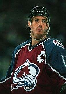
- Joe Sakic, NHL hockey player
- Mike Santorelli, NHL hockey player
- Murray SawChuck, Canadian-born Las Vegas-based magician
- Gurv and Harv Sihra, Indian-Canadian professional wrestlers known as Sunil and Samir Singh
- Josh Simpson, USL soccer player
- Christine Sinclair, NWSL soccer player and captain of the Canadian Women's National Soccer Team.
- Don Taylor, Vancouver-area television sportscaster
- Patrick Wiercioch, NHL hockey player
- Greg Zanon, AHL and NHL hockey player
Sister cities
Burnaby has four sister cities[13] (or "twin towns"):


Surrounding municipalities
Places adjacent to Burnaby | |
|---|---|
See also
References
- ↑ Census Profile, 2016 Census - Burnaby, City
- ↑ "Burnaby (city)". BC Geographical Names.
- ↑ "Burnaby, British Columbia". Canadian Climate Normals 1981–2010. Retrieved 17 February 2015.
- ↑ "Burnaby Population and Dwelling Count, 2011 Census". Statistics Canada. 11 September 2013. Retrieved 25 August 2016.
- ↑ "Burnaby Focus on Geography and Population, 2011 Census". Statistics Canada. 24 October 2012. Retrieved 25 August 2016.
- ↑ "Census Profile, 2016 Census - Burnaby, City, British Columbia". Statistics Canada. 25 January 2018. Retrieved 25 January 2018.
- ↑ "Burnaby Aboriginal Peoples, 2011 Census". Statistics Canada. 11 September 2013. Retrieved 25 August 2016.
- ↑ "Burnaby Religions, 2011 Census". Statistics Canada. 11 September 2013. Retrieved 25 August 2016.
- ↑ Moreau, Jennifer. "Newsmaker of the year: Jane Shin". Burnaby Now. Glacier Media. Retrieved 24 February 2016.
- ↑ MacQueen, Ken. "The best-run city in Canada: Lean, debt-free, and offering great public services, Burnaby is a model for the country". Retrieved 2009-08-04.
- ↑ Ted Mallett, Vice-President & Chief Economist, Simon Gaudreault, Senior Economist, Andreea Bourgeois, Senior Analyst. "Entrepreneurial Communities, Canada's top places to start and grow businesses in 2015" (PDF).
- ↑ Penner, Derrick (5 May 2009). "eBay to close Burnaby facility; about 700 jobs lost". Vancouversun.com. Retrieved 2010-07-27.
- ↑ http://www.burnaby.ca/About-Burnaby/Sister---Friendship-Cities.html
- Adapted from http://burnaby.ca
External links
| Wikimedia Commons has media related to Burnaby. |

- City of Burnaby
- Tourism Burnaby
- Burnaby Public Library
- Burnaby Parks and Rec
- British Columbia Institution of Technology
| Subdivisions |  | |
|---|---|---|
| Communities | ||
| Metro areas and agglomerations | ||
| ||
Municipalities of Metro Vancouver | |
|---|---|
| Population over 500,000 | |
| Population over 100,000 | |
| Population over 50,000 | |
| Population over 10,000 | |
| Population under 10,000 | |
| Unincorporated areas | |
| |