Bowen Island
| Bowen Island Nex̱wlélex̱m | |
|---|---|
| Island municipality | |
| Bowen Island Municipality[1] | |
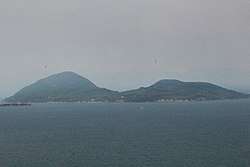 Bowen Island from the BC Ferry | |
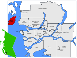 Location of Bowen Island in Greater Vancouver | |
| Country |
|
| Province |
|
| Regional District | Metro Vancouver Regional District |
| Incorporated | 1999 |
| Government | |
| • Mayor | Murray Skeels |
| • Councillors |
(list)[2]
|
| • MP | Pamela Goldsmith-Jones (Liberal) |
| • MLA | Jordan Sturdy (Liberal) |
| Area | |
| • Land | 50.14 km2 (19.36 sq mi) |
| Population (2016) | |
| • Total | 3,680 |
| • Density | 73.4/km2 (190/sq mi) |
| Time zone | UTC−8 (PST) |
| • Summer (DST) | UTC−7 (PDT) |
| Postal Codes |
V0N 1G0 V0N 1G1 V0N 1G2 |
| Website | Municipal Website |
|
| |
Bowen Island (originally Nex̱wlélex̱m in Sḵwx̱wú7mesh Sníchim), British Columbia, is an island municipality that is part of Metro Vancouver. In addition, Bowen Island is included within the jurisdiction of the Islands Trust.[3] Located in Howe Sound, Bowen Island is approximately 6 km wide by 12 km long, with the island at its closest point about 3 km west of the mainland. There is regular ferry service from Horseshoe Bay, as well as semi-regular water taxi services. The population of 3,680[4] is supplemented in the summer by roughly 1,500 visitors, as Bowen Island is a popular vacation home location for British Columbians. Approximately 500 workers and over 200 students commute to offices and schools on the mainland each day. The island has a land area of 49.94 km2 (19.28 sq mi).
History
Indigenous peoples
The name for Bowen Island is Nex̱wlélex̱m in the Squamish language of the Squamish people.[5] The Squamish peoples used and occupied the area around Howe Sound including Bowen Island.[6] Areas such as Snug Cove and a few other parts of the island were used as campsites for hunting and gathering trips.
Historically they would use the warmer spring and summer months to travel to resource gathering sites and move from their permanent winter villages. The strip of land between Bowen and Finisterre Islands has a name that translates to "Fast Drumming Ground". The tide rushing in and out is reminiscent of the sound of drums beating quickly. The name "Kwém̓shem" is used for Hood Point.[5] Bowen is still used by people from Squamish and Musqueam for deer hunting. Into the 20th century Bowen Island was actively used by Squamish people for deer and duck hunting, fishing and, later, wage jobs. In conversations with Vancouver archivist Major Matthews in the 1950s, August Jack Khatsahlano recalls knowing several Squamish who worked for whalers on the island at the turn of the 20th century. In a conversation with City of Vancouver archivist JA Matthews, Khatsahlano himself recalls deer hunting on Bowen, saying that at one time he took the biggest deer in British Columbia from the island, weighing in at 195 pounds.
Post-colonization
When Spanish explorers arrived on the west coast of Canada, they named many of the features of what is now the Strait of Georgia. Bowen Island was called Isla de Apodaca (after the Mexican town of Apodaca, in north-east Nuevo León province - itself named after a benevolent bishop, Salvador de Apodaca y Loreto) by the Spanish Captain José María Narváez in July, 1791.[7] In 1860 Cpt. George Henry Richards renamed the island after Rear Admiral James Bowen master of HMS Queen Charlotte.[8]:58
In 1871 homesteaders began to build houses and started a brickworks, which supplied bricks to the expanding city of Vancouver. Over the years, local industry has included an explosives factory, logging, mining, and milling, although there is no heavy industry on the island at present.
20th century
In the first half of the 20th century, life on Bowen was dominated by a resort operated by the Terminal Steamship Company (1900 - 1920) and the Union Steamship Company (1920 - 1962). These companies provided steamer service to Vancouver, and the Horseshoe Bay - Bowen Island Ferry began in 1921. When the Union Steamship resort closed in the 1960s the island returned to a quiet period of slow growth. In the 1940s and 1950s, the artists' colony called Lieben[9] was a retreat for many famous Canadian authors, artists, and intellectuals including Earle Birney, Alice Munro, Dorothy Livesay, Margaret Laurence, A.J.M. Smith, Jack Shadbolt, Eric Nicol and Malcolm Lowry, who finished his last book, October Ferry to Gabriola, there. In the 1980s, real estate pressures in Vancouver accelerated growth on Bowen and currently the local economy is largely dependent on commuters who work on the mainland in Greater Vancouver. Prior to becoming a municipality, Bowen Island was part of the Sunshine Coast Regional District, made up of small communities and municipalities. However, in the 1980s the island transferred to the Greater Vancouver Regional District after a campaign organized by developers and realtors. A campaign to make the island an autonomous municipality was successful after two referendum attempts.
In 1999 the Bowen Island Municipality was incorporated, becoming the second "island municipality" in BC. The first was Saltspring Island which was incorporated in 1873 and dissolved by the BC legislature 10 years later.
Commerce
Bowen Island is served by a number of small businesses including marinas, cafes, gift shops, grocery stores, a post office, pharmacy, restaurants, garden and flower shops, and a building supply yard. Bowen Island is served by First Credit Union, and by an Exchange Network ATM operated by North Shore Credit Union. Bowen Island's commercial sector is primarily located within Snug Cove and Artisan Square.
Transportation
Marine
Bowen Island is served by three scheduled water-transportation operators:
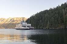
- BC Ferries, a de facto Provincial Crown corporation, serves the island with the Queen of Capilano car ferry, which travels between Horseshoe Bay in West Vancouver and Snug Cove on Bowen Island.
- English Bay Launch runs a passenger-only water taxi weekday commuter service between Snug Cove and Vancouver's Coal Harbour, and on summer weekends runs a tourist service between Snug Cove and Vancouver's Granville Island.
- Cormorant Marine[10] runs a passenger-only water taxi service providing late-night sailings between the government docks in Horseshoe Bay and in Snug Cove. In addition, weekday commuter sailings are made between Snug Cove and Horseshoe Bay, to connect with the Bowen Express Bus from downtown Vancouver.[11]
Land
Public roads are maintained by the Bowen Island Municipality. There are roadside walking trails in only a few places and the terrain is hilly and winding. Private vehicles are the primary form of transportation and hitchhiking is commonplace.
Bowen Island has a limited bus service (ending at 7 p.m.) of two TransLink routes:[12]
- Route 280 Bluewater/Snug Cove
- Route 281 Eagle Cliff/Snug Cove
Education
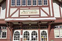
The Island is in the West Vancouver School district and has an one public elementary school named Bowen Island Community School. High school students living in Bowen Island (grades 8 to 12) travel to West Vancouver to attend West Vancouver Secondary School, Sentinel Secondary School, or Rockridge. There is the Island Pacific School, an international baccalaureate middle school for grades 6 through 9. Some students also travel to West Vancouver to attend French Immersion at Ecole Pauline Johnson. There is a public supported home learning program The Learning Centre and a growing number of families also unschool. Bowen Island houses a public library in the heritage Old General Store, that is also part of British Columbia's InterLink co-operative of public libraries.
Places of worship

There are a number of Christian churches on the Island. St Gerard's Catholic Church is located on Miller Road.[13] The United Church is situated in a timber building erected in 1932 a little further along on the same road. Also on Miller Road, nearer to Snug Cove, and meeting in Bowen Court, is Bowen Island Community Church,[14] an affiliate of the Congregational Christian Churches in Canada. Lastly, Cates Hill Chapel is a Christian Brethren church founded in 1991. Its present building on Carter Road was opened in 1999.[15] There are also regular meetings held by Unitarians and Quakers. Bowen Island is home to the Canadian branch of L'Abri, a communal Christian retreat centre where visitors come for self-directed study. Finally, Camp Bow-Isle is a summer camp for Christian Scientists.
There are regular Buddhist meditation sittings in both the Zen and Vipassana traditions.
Bowen's Jewish community celebrates Shabbat and high holidays, and acquired a Torah in 2006.
Demographics
| Canada 2006 Census | Population | % of Total Population | |
|---|---|---|---|
| Visible minority group Source:[16] | South Asian | 10 | 0.3% |
| Chinese | 40 | 1.2% | |
| Black | 15 | 0.4% | |
| Filipino | 10 | 0.3% | |
| Southeast Asian | 25 | 0.7% | |
| Japanese | 30 | 0.9% | |
| Other visible minority | 10 | 0.3% | |
| Mixed visible minority | 40 | 1.2% | |
| Total visible minority population | 185 | 5.5% | |
| Aboriginal group Source:[17] | First Nations | 120 | 3.6% |
| Total Aboriginal population | 130 | 3.9% | |
| European Canadian | 3,045 | 90.6% | |
| Total population | 3,360 | 100% | |
Films shot entirely or partly on Bowen Island
- 1966 The Trap[18]
- 1976 The Food of the Gods[19]
- 1986 Clan of the Cave Bear
- 1988 People Across the Lake
- 1988 American Gothic[20]
- 1989 Cousins
- 1989 Look Who's Talking
- 1990 Bird on a Wire
- 1990 The Russia House[21]
- 1993 Another Stakeout[22]
- 1994 Intersection
- 1995 Hideaway
- 1997 All the Winters That Have Been
- 1998 Disturbing Behavior[23]
- 1999 Double Jeopardy[24]
- 2001 Antitrust
- 2004 Rugged Rich and the Ona Ona[25]
- 2005 The Fog[26]
- 2005 Paper Moon Affair[27]
- 2006 The Hitchhiker[28]
- 2006 The Wicker Man[29]
- 2008 Are We Still the Ugly American?[30]
- 2008 River[31]
- 2009 The Uninvited[32]
- 2009 Harper's Island, CBS 13-episode miniseries.
References
- ↑ "British Columbia Regional Districts, Municipalities, Corporate Name, Date of Incorporation and Postal Address" (XLS). British Columbia Ministry of Communities, Sport and Cultural Development. Archived from the original on July 13, 2014. Retrieved November 2, 2014.
- ↑ "Council Members". Bowen Island Municipal Website. Retrieved 2015-03-05.
- ↑ "Archived copy". Archived from the original on 2011-11-22. Retrieved 2011-11-17.
- ↑ Bowen Island population - 2016 Census
- 1 2 Squamish Nation "Skwxwu7mesh Snichim-Xweliten Snichim Skexwts / Squamish-English Dictionary", Published 2011. pg.235. ISBN 0-295-99022-8
- ↑ Squamish Nation "Skwxwu7mesh Snichim-Xweliten Snichim Skexwts / Squamish-English Dictionary", Published 2011. pg.x. ISBN 0-295-99022-8
- ↑ "Bowen Island". BC Geographical Names.
- ↑ Walbran, Captain John T. (1971). British Columbia Place Names, Their Origin and History (Facsimile reprint of 1909 ed.). Vancouver/Toronto: Douglas & McIntyre. ISBN 0-88894-143-9.
- ↑ "Bowen Island Museum & Archives: Lieben: An Artist Colony". Bowenislandmuseum.ca. 2014-06-20. Retrieved 2017-04-14.
- ↑ "Cormorant Marine". Cormorantwatertaxi.com. Retrieved 2017-04-14.
- ↑ "Bowen Express Bus". Sites.google.com. Retrieved 2017-04-14.
- ↑ "TransLink - Transit Schedules". Tripplanning.translink.ca. Retrieved 2017-04-14.
- ↑ "St. Gerard's Catholic Christian Church, Bowen Island, BC, Canada". Stgerards.rcav.org. Retrieved 2017-04-14.
- ↑ "Bowen Island Community Church". Bowencommunitychurch.org. 2017-04-10. Retrieved 2017-04-14.
- ↑ "Cates Hill Chapel / Welcome". Cateshillchapel.com. Retrieved 2017-04-14.
- ↑ Island&SearchType=Begins&SearchPR=01&B1=All&Custom=, Community Profiles from the 2006 Census, Statistics Canada - Census Subdivision
- ↑ , Aboriginal Peoples - Data table
- ↑ Weblink to some great photos of the village on the Rita Tushingham homepage: "Archived copy". Archived from the original on 2007-12-23. Retrieved 2007-11-05.
- ↑ "Stomp Tokyo Video Reviews - The Food of the Gods". Stomptokyo.com. Retrieved 2017-04-14.
- ↑ https://www.imdb.com/title/tt0094642/locations
- ↑ https://www.imdb.com/title/tt0100530/locations
- ↑ https://www.imdb.com/title/tt0106292/locations
- ↑ "Archived copy". Archived from the original on 2005-11-27. Retrieved 2006-04-14.
- ↑ https://www.imdb.com/title/tt0150377/locations
- ↑ https://www.imdb.com/title/tt0404387/
- ↑ https://www.imdb.com/title/tt0432291/locations
- ↑ https://www.imdb.com/title/tt0433615/
- ↑ https://www.imdb.com/title/tt0852964/
- ↑ https://www.imdb.com/title/tt0450345/locations
- ↑ https://www.imdb.com/title/tt1304567/
- ↑ https://www.imdb.com/title/tt1342927/
- ↑ https://www.imdb.com/title/tt0815245/locations
External links
| Wikimedia Commons has media related to Bowen Island. |
| Wikivoyage has a travel guide for Bowen Island. |
- Bowen Island Municipality - official site for municipal government
- Community Profile: Bowen Island Island Municipality, Greater Vancouver Regional District, British Columbia; Statistics Canada
Further reading
- Hanen, Edythe Anstey (2004). Bowen Island Reflections. Bowen Island Historians, 160 pp.
- Howard, Irene (1973). Bowen Island 1872-1972. Bowen Island Historians, 190 pp.
- Ommundsen, Peter D. (1997). Bowen Island Passenger Ferries. The Sannie Transportation Company 1921-1956. Cape West Publishing, 64 pp.
Places adjacent to Bowen Island | ||||||||||
|---|---|---|---|---|---|---|---|---|---|---|
| ||||||||||
Municipalities of Metro Vancouver | |
|---|---|
| Population over 500,000 | |
| Population over 100,000 | |
| Population over 50,000 | |
| Population over 10,000 | |
| Population under 10,000 | |
| Unincorporated areas | |
| |
| Provinces | |
|---|---|
| Territories | |
| Other countries | |
| |