British Columbia Highway 1A
| ||||
|---|---|---|---|---|
| Route information | ||||
| Auxiliary route of Hwy 1 | ||||
| Highway system | ||||
|
British Columbia provincial highways
| ||||

There are many roads in the southwestern part of British Columbia and Vancouver Island that were designated as Highway 1A. These roads were sections of the original 1941 route of Highway 1 before its various re-alignments, and are used today as service routes and frontage roads. The "B.C. Highway 1A" designations were removed from these sections by the province between 2005 and 2010, although signage remains along some of the route and the designation on some maps.
Vancouver Island
North Cowichan
| |
|---|---|
| Location | North Cowichan, Ladysmith |
| Length | 17.4 km[1] (10.8 mi) |
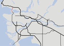
A 17 km (11 mi) long segment of highway in North Cowichan and Ladysmith designated as Highway 1A. It starts in the south at the intersection of Highway 1 and Mount Sicker Road, the Highway follows Mount Sicker Road and Chemainus Road east for 2.3 km (1.4 mi) to an intersection with Crofton Road, which provides access to the community of Crofton. Chemainus Road and Highway 1A turns northwest, and goes for 15 km (9.3 mi) through Chemainus to the intersection with Roland Lane, where it subsequently turns west to meet the Trans-Canada Highway on the south end of Ladysmith.[1] This route was the original Island Highway prior to the opening of the existing Trans-Canada Highway, which was constructed to bypass the Chemainus area in 1950.
Greater Victoria
(Island Highway) | |
|---|---|
| Location | Victoria, Esquimalt, Colwood, Langford |
| Length | 16 km (9.9 mi) |
| Existed | 1956–1990s |
Since 1941, Highway 1A went from Victoria to Kelsey Bay. It ended at the wharf. By the 1960, Highway 1 ended at Nanaimo's Departure Bay Ferry terminal.
A 16 km (10 mi) long segment of highway in the area of Victoria was designated as Highway 1A. It started in Victoria at the intersection of Hillside Avenue and Government Street, following Gorge Road west for 5 km (3 mi) until it reached an intersection at Admirals Road, just across the Craigflower Bridge into Esquimalt. Highway 1A then proceeded west along the Old Island Highway for 5 km (3 mi) to a junction with Highway 14 at Goldstream Avenue. Highway 1A turned onto Goldstream Avenue and proceeded west for 6 km (4 mi) to its termination at Highway 1 just short of Goldstream Provincial Park. This route was the original Island Highway prior to the opening of the existing Trans-Canada Highway route in 1955 and 1956.
Lower Mainland
Until the Highway 1 Freeway (originally the "401") was built in the mid 1960s, much of the Fraser Highway was part of the Trans-Canada Highway. It was built along the route of Old Yale Road, which was first built in 1874 between Yale and New Westminster. The Fraser Highway route was designated as Hwy. 1 from 1941 to 1972 while the new Freeway was designated as Hwy. 401 until 1972. In 1973, the Freeway route became Hwy. 1 while the Fraser Highway became Hwy. 1A.
North Shore
| |
|---|---|
| Location | West Vancouver, North Vancouver, Vancouver |
| Length | 4.0 km (2.5 mi) |
| Existed | 1973–2016 |
A 4 km (2 1⁄2 mi) segment of road between West Vancouver and Vancouver was designated as Highway 1A. It began in the north by sharing the alignment with Highway 99 from the Highway 1 interchange at Taylor Way over the Lions Gate Bridge and along the Stanley Park Causeway, and terminated at the edge of Stanley Park to become Georgia Street. As it was concurrent with Highway 99 for its entire length, the 1A designation was redundant and was dropped in 2016.[1][2]
Kingsway & Fraser Highway
(Kingsway, Fraser Highway) | |
|---|---|
| Location | Vancouver, Burnaby, New Westminster, Surrey, Langley, Abbotsford |
| Length | 28 km (17 mi) |
| Existed | 1973–2006 |
It formerly shared a 28 km (17 mi) alignment with Highway 99A from the Stanley Park Causeway and the West End and Downtown Vancouver all the way to 98 Avenue in Surrey via West Georgia Street, Seymour Street, Main Street, Kingsway, 10th Avenue, McBride Boulevard, the Pattullo Bridge and King George Boulevard (formerly and still known as the King George Highway) at which point Highway 1A diverged east. East of the diverge, Highway 1A was known locally as the Fraser Highway. The two- and four-lane highway went southeast for 9 km (6 mi) to its junction with Highway 15 in Surrey, then continued southeast for 5 km (3.1 mi) to a junction with Highway 10 in Langley. Highway 1A briefly left Fraser Highway (which passes through downtown Langley), following Langley Bypass and a 2 km (1 1⁄4 mi) concurrency with Highway 10 to Glover Road, rejoining Fraser Highway 1 km (1⁄2 mi) afterward. Another 15 km (9 mi) southeast and Highway 1A reached an intersection with Highway 13 at Aldergrove. 9 km (5 mi) east of the Highway 13 junction, the 1A segment finally terminated at an interchange with Highway 1 just west of Abbotsford (Exit 83).
With the decommissioning of the "B.C. Highway 1A" designation, the original Trans-Canada Highway route is now known merely as the Fraser Highway (Surrey to Abbotsford)
Chilliwack
| |
|---|---|
| Location | Chilliwack |
| Length | 18 km (11 mi) |
| Existed | 1960s–1990s |
The Chilliwack-Rosedale Yale Road East section ran from the Trans-Canada Highway at the Vedder Road crossing (Exit 119), through Chilliwack, Cheam and Rosedale, and reconnecting to the Trans-Canada Highway along with Highway 9 (Exit 135). This section of what was originally the Yale Road was part of the original Trans-Canada Highway route until the completion of the "401" Freeway section in the 1960s. In 2005, the City of Chilliwack posted signage along the Yale Road East section designating it as the "Trans-Canada Parallel Route".
Kicking Horse Pass
| |
|---|---|
| Location | Yoho National Park |
| Length | 2.0 km[3] (1.2 mi) |
| Existed | 1962–2000s |
A former section of Highway 1A exists along the former Kicking Horse Trail, the original road between Lake Louise and Golden that opened in 1926.[4] When the Trans-Canada Highway was realigned in 1962, the segment became Highway 1A.[5] It began at Highway 1, 3 km (2 mi) west of the Alberta border in Yoho National Park and meandered eastward through Kicking Horse Pass to Lake Louise. The route is now closed to vehicle traffic and is part the Great Divide hiking trail.[6]
References
- 1 2 3 Landmark Kilometre Inventory (PDF). British Columbia Ministry of Transportation and Infrastructure (Report). Cypher Consulting. July 2016. pp. 70–71.
- ↑ "Official Numbered Routes in British Columbia". Ministry of Transportation and Infrastructure. Province of British Columbia. June 8, 2015. Retrieved January 3, 2017.
- ↑ "Short Hikes - Great Divide". Parks Canada: Yoho National Park. Government of Canada. June 19, 2015. Retrieved January 11, 2017.
- ↑ Williams, M.B.; National Parks of Canada (1930). The Kicking Horse Trail: Scenic Highway from Lake Louise, Alberta to Golden, British Columbia (PDF). Ottawa, ON: F.A. Acland: Printer to the King's Most Excellent Majesty. p. 21. Retrieved October 13, 2017.
- ↑ "Kicking Horse Pass National Historic Site of Canada". Parks Canada. Government of Canada. March 22, 2012. Retrieved October 13, 2017.
- ↑ Map of Yoho National Park (PDF). Parks Canada. 2015.