Bteghrine
| Bteghrine بتغرين | |
|---|---|
| City | |
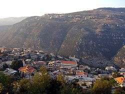 Overlooking Bteghrine (2005) | |
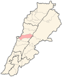
 Bteghrine Location within Lebanon | |
| Coordinates: 33°55′48″N 35°44′42″E / 33.93000°N 35.74500°ECoordinates: 33°55′48″N 35°44′42″E / 33.93000°N 35.74500°E | |
| Country |
|
| Governorate | Mount Lebanon Governorate |
| District | Matn District |
| Government | |
| • President | Mirna Michel el-Murr |
| • Vice President | Emile Murad Saliba |
| • Mayors |
Nejm Elias Saliba Jean Jamil Saliba Jean Mansour Saliba |
| Elevation | 950 m (3,120 ft) |
| Highest elevation | 1,100 m (3,600 ft) |
| Lowest elevation | 950 m (3,120 ft) |
| Population | |
| • Total | 12,000 |
| Time zone | UTC+2 (EET) |
| • Summer (DST) | UTC+3 (EEST) |
| Dialing code | +961 |
Bteghrine (Arabic: بتغرين, also spelled Bteghrin and Btighrin) is a municipality in the Matn District of the Mount Lebanon Governorate of Lebanon.
Etymology
The exact origin of the town name Bteghrine is unknown, but possibilities include Place of Warriors, Place of Rocks, and House of the Saddest - references to a large battle in the area around 1290 that resulted in thousands of deaths.[1] This date corresponds closely with the rise of the Mamluks, a period which saw numerous battles in the area, including a 1291 rebellion by the Shi'a against the new rulers in Keserwan, the district on the northern border of the Matn.[2]
Geography
Bteghrine is located at 33°55′48″N 35°44′42″E / 33.93°N 35.745°E. It is bordered by Mount Sannine to the east, Wadi el-Jamajem to the north, Jouar to the west, and Khenchara to the south. The municipality is composed of seven neighborhoods and four outlying areas.
Neighborhoods
- Haret al-Ain
- Haret al-Dara
- Haret al-Shahara
- Haret al-Shawyee
- Haret al-Ssaha
- Haret al-Wata
- Haret Ali
- Haret al-Asfourieh
Outlying areas

- Bsefrine
- Meisree
- Sabourta
- Zaarour
Water
There are several springs used for both drinking water and agricultural purposes in Bteghrine. The four primary springs are Zaarour, Manboukh, Mir, and Sparta.
Agriculture
Bteghrine is situated on a rocky hillside, but supports a thriving, self-sufficient agriculture. Most of the land within the city and the surrounding hills, including the Meisree and Bsefrine districts, was fully terraced to make it more suited for planting. The most common fruits and vegetables grown in Bteghrine are: figs, grapes, mulberry, plums, apples, peaches, persimmon, pomegranate, cherries, tomatoes, cucumber, parsley, mint, wheat, and beans. Small shops in the town process much of the local produce into arak, molasses, wine, and preserves.
Economy

The Saliba Nail and Screw factory is the largest single plant in Bteghrine. Additionally, the town has a large number of small shops for blacksmithing, woodworking, car repair and bodywork, leather tailoring, and aluminum manufacturing. The city also enjoys a full set of services including three gas stations, a supermarket, dry cleaner, several specialty and general stores, a large bakery, several bookstores, several clinics, many restaurants, and one hotel. Bteghrine also hosts the central telephone station for the upper Metn region.
Education
There is one public school in the town named Bteghrine Public School, and one private Catholic school.
Religion
The inhabitants of Bteghrine are almost all Christians, 75% Greek Orthodox and 25% Melkite Catholic.
Churches
- St. George – Greek Orthodox.
- St. Michael – Greek Orthodox.
- St. Elias – Greek Orthodox.
- Notre Dame – Melkite Catholic.
Famous Bteghrineites
- Antonious Saliba - Orthodox Priest in the 19th century who has had miracles attributed to them. Currently in process for sainthood.
- Elias Murr – Lebanese Deputy Prime Minister and Defense Minister
- George Hawi – former Secretary General of the Lebanese Communist Party, assassinated June 21, 2005 by a bomb planted under his car
- Greg Simon (Saliba) – current President of the Washington, D.C. based think tank FasterCures, Chief Domestic Policy Advisor to former Vice President Al Gore from 1993 to 1997
- Michel Murr – former Lebanese Minister of the Interior
- Naseeb M. Saliba - Co-founder of the Tutor-Saliba Corporation, one of the largest construction companies in the United States. Responsible for the construction of LAX, SFO, The Olympic Stadium in Los Angeles, among many others major United States landmarks.
- George Elie Nassar El Murr -One of the first Lebanese assented in America..
- George A. Saliba - CTO of multibillion-dollar Quantum Corp. Currently has over 100 patents (published or in process) and is internationally recognized as an industry pioneer and inventor in data storage.
- Gabriel Murr – former Lebanese Minister of the Interior (July 26, 1948 – October 10, 1949)
- Richard Saliba- full scholarship at Harvard University (2011-2015)
References
- ↑ "History of Bteghrine". Retrieved November 11, 2006.
- ↑ Library of Congress. "A Country Study: Lebanon". Retrieved November 29, 2006.
External links
- Bteghrine, Localiban
- Bteghrine.com
- Lebanese Government Portal for Information & Forms - Municipality of Bteghrine
- Tutorsaliba.com
Capital: Jdeideh | ||
| Towns and villages |
|  |
| Notable landmarks | ||
| Notable touristic sites | ||