Jouret el ballout
| jouret el ballout |
|---|
| lowest elevation:600m |
| highest elevation:720m |
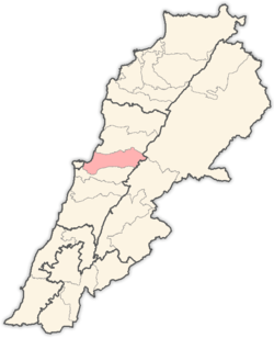
| district:northern maten |
Jouret El Ballout is a christian Lebanese local authority which is located in Matn District (Qada'a), an administrative division of Mount Lebanon Governorate (Mohafazah).
The village of “Jouret El-Ballout” owes its name to its geographical position in a pit - a low point surrounded by mountains, mar chaaya mountain from the north and the HAREF mountain from the west - (“Joura” in Familiar Arabic). It is also surrounded by tall pine and oak trees bearing acorns (“Ballout” in Arabic). Therefore, the name is a description of the village: The Pit of Acorns.
Location
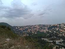
Jouret El-Ballout, situated 20 km east of Beirut, covers an area of 169 hectares in the Qada’a of the Northern Metn, in the Mohafaza of Mount Lebanon. It is bordered by Nabay from the west, Deir Mar Cha’aya from the north, Broummana from the east and Kannaba Broummana from the south. It stands at an altitude of 720 m above sea level and it has a very beautiful view on beirut and the mediterranean
climate
Summer is usually dry in jouret el ballout; it begins in early May and ends in mid-October. Summer temperature rarely exceeds 30°C, with a lower limit of around 20°C (68°F). Its relative humidity in summer runs at 68%. Winter is wet and mild with temperatures ranging between 5°C and 18°C, with the occasional snowfall the lowest temperature is variable but the lowest recorded few years ago about -4 during a snow storm
it can be reached via 3 different routes:
Mkalles - Beit Merry - Broumanna - Jouret El-Ballout
or Antelias - Deir As-Salib - Nabay - Jouret El-Ballout
and maten highway
Archeological and Cultural Sites
Despite the relatively recent inception of the village, remains of several stone and earthen sarcophagi have been found there. The region of A’aranta in Jouret El-Ballout is in fact well-known for its archeological wealth: remains of an old fortress were discovered, as well as some Phoenicians and Romanian tombs. Excavation works also showed that wood blast furnaces going back to the Phoenician era existed on this site.
Educational and Social Institutions
A public school was founded in the village in 1946, but it closed in 1980's. Today, there are two private schools in Jouret El-Ballout:
- Collège Louise Wegmann.
- Valley International School.
References
Capital: Jdeideh | ||
| Towns and villages |
|  |
| Notable landmarks | ||
| Notable touristic sites | ||