Santa Bárbara, Cape Verde
| Santa Bárbara | |
|---|---|
| Settlement | |
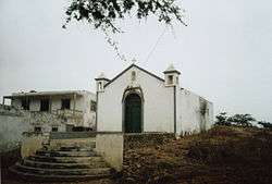 Church | |
 Santa Bárbara | |
| Coordinates: 14°52′30″N 24°41′06″W / 14.875°N 24.685°WCoordinates: 14°52′30″N 24°41′06″W / 14.875°N 24.685°W | |
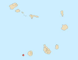
| Country | Cape Verde |
| Island | Brava |
| Municipality | Brava |
| Civil parish | São João Baptista |
| Elevation | 350 m (1,150 ft) |
| Population (2010)[1] | |
| • Total | 143 |
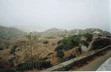
View from Nova Sintra to Santa Bárbara.
Santa Bárbara (Portuguese meaning Saint Barbara) is a village in the northeastern part of the island of Brava, Cape Verde. It is situated at 350 m elevation, close to the Atlantic coast. It is about 1 kilometer east of the island capital of Nova Sintra. To its southeast is the small village of Vinagre. Santa Bárbara can be reached by "Aluguer" buses.
References
- ↑ "2010 Census results". Instituto Nacional de Estatística Cabo Verde (in Portuguese). 24 November 2016.
The Island of Brava | ||
|---|---|---|
| Communities and settlements |
|  |
| Parishes | ||
| Other geographical features | ||
| Landmarks and points of interests | ||
This article is issued from
Wikipedia.
The text is licensed under Creative Commons - Attribution - Sharealike.
Additional terms may apply for the media files.