Bir El Hafey
| Bir El Hafey بئر الحفي | |
|---|---|
| Commune and town | |
 Bir Lihfey-edit. | |
| Nickname(s): l'hafey | |
| Country |
|
| Governorate | Sidi Bouzid Governorate |
| Government | |
| • Mayor | Abdelkader Akrimi.[1] |
| Population (2014) | |
| • Total | 6,498 |
| Time zone | UTC+1 (CET) |
|
bir el hafey is a town near sisi bouzid,souk jedid,el fetah and hichria (brige) the benefits of having bir el hafey near to most citizens in the rural area is that they tend to send their children to their high schools and shop in their larger than local businesses. It is also surrounded by mountains (fairly small) and has a good view of the Atlas mountain range. | |
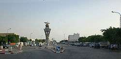
Bir El Hafey is a town and commune located at 34°55′48″N 9°12′00″E in the Sidi Bouzid Governorate, in Tunisia (Maghreb, North Africa). As of 2004 it had a population of 36,405.[2]
Bir El Hafey (Arabic: بئر الحفي) , located about thirty kilometers south of Sidi Bouzid, in the southern foothills of the Tunisian ridge. Attached to the governorate of Sidi Bouzid, it is a municipality with 6,475 inhabitants in 20142. It is also the capital of a delegation.
It is in crossroads position on the Kairouan-Gafsa axis because crossed by the RN3 while being connected to Sidi Bouzid, the chief town of the governorate.
History of Nara
Bir El Hafey is the modern site of the Ancient, notably Roman, city of Nara.
Ecclesiastical history
Nara was important enough in the Roman province of Byzacena to become a suffragan bishopric of the Metropolitan Achbishop of Hadrumetum, but faded.[3][4][5] There are three bishops documented from Nara.
- Crescenziano participated in the Council of Cabarsussi, held in 393 by the Maximianists, a dissident sect of the Donatists, and he signed the council's acts.
- The Donatist Gennaro intervened at the 411 Carthage conference, which saw the Catholic and donatists from all over Roman North Africa debate. On that occasion the town had no Catholic bishops.
- Vittore was present at the synod assembled in Carthage in 484 by King Huneric of the Vandal Kingdom. After the council Vittore was exiled.
Titular see of Nara
The diocese was nominally in 1925 restored as a Latin titular bishopric.[6] [7]
It has had the following incumbents, all of the lowest (episcopal) rank :
- Raffaele Angelo Palazzi (柏長青), Friars Minor (O.F.M.) (1928.06.15 – 1946.04.11)
- Patrick Dunne (1946.08.08 – 1988.03.16)
- Nino Marzoli, Resurrectionists (C.R.) (1988.04.16 – 2000.05.24)
- Jerome Edward Listecki (2000.11.07 – 2004.12.29), later Archbishop )
- Jerzy Maculewicz, Conventual Franciscans (O.F.M. Conv.), Apostolic Administrator of Uzbekistan (2005.04.01 – ...)
Population
In 2004 the population of the town was 5589, and in 2014 this had increased to 6475.
See also
References
- ↑ Décret du 14 octobre 2013 portant dissolution du conseil municipal de Bir El Hafey du gouvernorat de Sidi Bouzid et désignation d'une délégation spéciale, Journal officiel de la République tunisienne, n°84, 22 octobre 2013, p. 3056.
- ↑ (in French) Recensement de 2004 (Institut national de la statistique) Archived 2015-09-24 at the Wayback Machine.
- ↑ Pius Bonifacius Gams, Series episcoporum Ecclesiae Catholicae, (Leipzig, 1931), p. 467.
- ↑ Stefano Antonio Morcelli, Africa christiana, Volume I, (Brescia, 1816), p. 240.
- ↑ J. Mesnage, L'Afrique chrétienne, (Paris, 1912), p. 77.
- ↑ Nara at www.catholic-hierarchy.org.
- ↑ Nara at www.gcatholic.org.
Sources and external links
Coordinates: 34°56′N 9°12′E / 34.933°N 9.200°E