Jendouba
| Jendouba جندوبة | |
|---|---|
 Jendouba | |
| Coordinates: 36°29′N 08°47′E / 36.483°N 8.783°E | |
| Country | Tunisia |
| Governorates | Jendouba Governorate |
| Government | |
| • Ayoub Hajji | Ayoub Hajji |
| Elevation | 143 m (469 ft) |
| Population (2014) | |
| • Total | 46,459 |
| Time zone | UTC+1 (CET) |
| • Summer (DST) | UTC+2 (CEST) |
| Website | www.commune-jendouba.gov.tn |
Jendouba (Jendouba) (Tunisian Arabic: جندوبة ![]()
History
Historically, this region was important and wealthy.
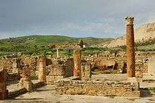
During the Roman Empire the town was called Libertina and was a civitas of the Roman Province of Byzacena in North Africa. The historical importance of the area is evidenced by the nearby great Roman cities of Bulla Regia and Chemtou. Several other historical sites witness the role this city played centuries ago in the economic life of the region.
Around 670 the town fell to the Muslim conquest of the Maghreb.
Under the French, Jendouba Ville is remembered as the Tunisian area where the civil demand for independence from French colonization started on April 9, 1934. The protests started in the town of Oued Meliz on April 4, 1934 before arriving in the capital and becoming a national movement.This city is also home to Dallas Mavericks center Salah Mejri.
.jpg)
The "events of April 9, 1938 " ( 9 أحداث أفريل 1938) were street protests demanding political reforms, including the establishment of a parliament, a major step towards the independence of Tunisia whilst a French protectorate. They resulted in a bloody shootout that marked the start of the Tunisian national movement.
During World War 2 there was an airfield outside the village. During Operation Torch, the town and was captured by paratroops of the British 1st Parachute Brigade on 16 November 1942.[1]
Climate
In Jendouba, the climate is warm and temperate. In winter there is much more rainfall than in summer. The Köppen-Geiger climate classification is Csa. The average annual temperature in Jendouba is 18.0 °C (64.4 °F). About 504 mm (19.84 in) of precipitation falls annually.
| Climate data for Jendouba | |||||||||||||
|---|---|---|---|---|---|---|---|---|---|---|---|---|---|
| Month | Jan | Feb | Mar | Apr | May | Jun | Jul | Aug | Sep | Oct | Nov | Dec | Year |
| Average high °C (°F) | 14.7 (58.5) |
15.8 (60.4) |
18.8 (65.8) |
21.7 (71.1) |
25.7 (78.3) |
32.5 (90.5) |
36.7 (98.1) |
36.7 (98.1) |
32.6 (90.7) |
25.8 (78.4) |
19.9 (67.8) |
15.7 (60.3) |
24.7 (76.5) |
| Average low °C (°F) | 5.0 (41) |
5.1 (41.2) |
6.6 (43.9) |
8.6 (47.5) |
12.3 (54.1) |
16.3 (61.3) |
18.3 (64.9) |
19.1 (66.4) |
17.1 (62.8) |
13.3 (55.9) |
9.2 (48.6) |
6.1 (43) |
11.4 (52.6) |
| Average precipitation mm (inches) | 69 (2.72) |
56 (2.2) |
53 (2.09) |
45 (1.77) |
36 (1.42) |
19 (0.75) |
4 (0.16) |
9 (0.35) |
36 (1.42) |
55 (2.17) |
55 (2.17) |
67 (2.64) |
504 (19.84) |
| Source: Climate-Data.org,Climate data | |||||||||||||
Economy
Coordinates: 36°30′N 8°47′E / 36.500°N 8.783°E

References