Nabeul Governorate
| Nabeul ولاية نابل | |
|---|---|
| Governorate | |
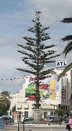 The center of Nabeul. | |
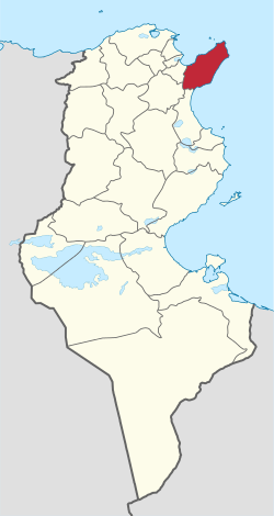 Map of Tunisia with Nabeul highlighted | |
| Coordinates: 36°45′N 10°45′E / 36.750°N 10.750°ECoordinates: 36°45′N 10°45′E / 36.750°N 10.750°E | |
| Country | Tunisia |
| Created | June 21, 1956 |
| Capital | Nabeul |
| Area | |
| • Total | 2,788 km2 (1,076 sq mi) |
| Area rank | Ranked 17th of 24 |
| Population (2014) | |
| • Total | 787,920 |
| • Rank | Ranked 3rd of 24 |
| • Density | 280/km2 (730/sq mi) |
| Time zone | UTC+01 (CET) |
| Postal prefix | xx |
| ISO 3166 code | TN-21 |
Nabeul Governorate (Tunisian Arabic: ولاية نابل Wilāyat Nābil Tunisian pronunciation: [ˈnɛːbɪl]) is one of the 24 governorates of Tunisia. It is situated in north-eastern Tunisia. It covers an area of 2,788 km² and has a population of 787,920 (2014 census).[1] The capital is Nabeul.
Nabeul is surrounded by the Mediterranean Sea, except the south west side where it is delimited by the three governorates Zaghouan, Sousse and Ben Arous.
History
Nabeul, the main city of the governorate, was founded in the 5th century BC by the Greeks of Cyrene, serving as a trade port. Its name is an Arabised form of the Greek Neapolis 'new city' (an etymology it shares with Naples, Neapoli, and Nablus).
Climate
Nabeul has an arid climate with steppe precipitation and hot arid temperature.[2]
| Climate data for Nabeul | |||||||||||||
|---|---|---|---|---|---|---|---|---|---|---|---|---|---|
| Month | Jan | Feb | Mar | Apr | May | Jun | Jul | Aug | Sep | Oct | Nov | Dec | Year |
| Record high °C (°F) | 24 (76) |
23 (74) |
28 (83) |
27 (80) |
29 (84) |
36 (97) |
39 (103) |
41 (105) |
37 (99) |
34 (94) |
26 (79) |
23 (74) |
41 (105) |
| Average high °C (°F) | 15 (59) |
16 (60) |
17 (62) |
18 (65) |
22 (71) |
26 (79) |
29 (85) |
30 (86) |
28 (82) |
24 (76) |
20 (68) |
16 (61) |
22 (71) |
| Average low °C (°F) | 9 (49) |
10 (50) |
11 (52) |
19 (66) |
17 (63) |
21 (70) |
24 (75) |
24 (76) |
23 (73) |
19 (67) |
15 (59) |
11 (52) |
17 (62) |
| Record low °C (°F) | 2 (36) |
2 (36) |
4 (40) |
7 (45) |
11 (52) |
16 (60) |
17 (63) |
19 (67) |
15 (59) |
9 (49) |
6 (43) |
3 (38) |
2 (36) |
| Source: Weatherbase [3] | |||||||||||||
Administrative divisions
| Delegation[4] | Population in 2004[5] |
|---|---|
| Béni Khalled | 33,897 |
| Béni Khiar | 35,565 |
| Bou Argoub | 27,846 |
| Dar Châabane El Fehri | 39,477 |
| El Haouaria | 39,378 |
| El Mida | 23,667 |
| Grombalia | 55,489 |
| Hammam El Guezaz | 14,324 |
| Hammamet | 95,468 |
| Kélibia | 53,648 |
| Korba | 60,564 |
| Menzel Bouzelfa | 33,599 |
| Menzel Temime | 59,463 |
| Nabeul | 59,490 |
| Soliman | 41,846 |
| Takelsa | 20,169 |
The following 24 municipalities are located in Nabeul Governorate: | 1511 | Nabeul | 70,437 |- | 1512 | Dar Chaabane | 42,140 |- | 1513 | Béni Khiar | 21,626 |- | 1514 | El Maâmoura | 8,039 |- | 1515 | Somâa | 7,017 |- | 1516 | Korba | 38,902 |- | 1517 | Tazerka | 9,388 |- | 1518 | Menzel Temime | 39,138 |- | 1519 | Menzel Horr | 5,243 |- | 1520 | El Mida | 4,155 |- | 1521 | Kelibia | 46,856 |- | 1522 | Azmour | 5,054 |- | 1523 | Hammam Ghezèze | 9,076 |- | 1524 | Dar Allouch | 4,558 |- | 1525 | El Haouaria | 9,508 |- | 1526 | Takelsa | 22,151 |- | 1527 | Soliman | 37,749 |- | 1528 | Korbous | 3,532 |- | 1529 | Menzel Bouzelfa | 18,551 |- | 1530 | Béni Khalled | 15,463 |- | 1531 | Zaouiet Djedidi | 7,862 |- | 1532 | Grombalia | 24,299 |- | 1533 | Bou Argoub | 11,990 |- | 1534 | Hammamet | 73,236
References
- ↑ (in French) Census 2014 (National Institute of Statistics) Archived 2014-10-29 at the Wayback Machine.
- ↑ World Map of the Köppen-Geiger climate classification updated, Meteorologische Zeitschrift, Vol.15, No. 3, 259-263 (June 2006)
- ↑ "Weatherbase: Historical Weather for Nabeul, Tunisia". Weatherbase. 2011. Retrieved on September 11, 2013.
- ↑ (in French) "Gouvernorat de Nabeul" Portail de l'industrie Tunisienne Archived 2009-02-17 at the Wayback Machine.
- ↑ (in French) 2004 Census: Nabeul Governorate from Institut national de la statistique of Tunisia
Governorates and regions of Tunisia | ||
|---|---|---|
| Governorates | ||
| Regions |
| |
WikiProject Tunisia | ||