Glendale, Queens
| Glendale | |
|---|---|
| Neighborhoods of Queens | |
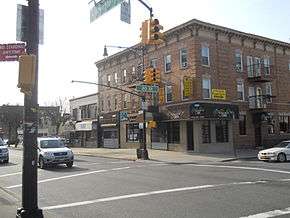 Myrtle Avenue in Eastern Glendale | |
|
Location within New York City | |
| Coordinates: 40°42′N 73°53′W / 40.7°N 73.88°WCoordinates: 40°42′N 73°53′W / 40.7°N 73.88°W | |
| Country |
|
| State |
|
| City |
|
| County/Borough |
|
| Founded | 1642 |
| Population (2010)[1] | |
| • Total | 32,496 |
| Race/Ethnicity[2] | |
| • White | 61.4% |
| • Hispanic | 33.4 |
| • Asian | 3.1 |
| • Black | 1.2 |
| • Other | 0.9 |
| ZIP codes | 11385 |
| Area code(s) | 718, 347, 929, and 917 |
Glendale is a neighborhood in the west-central portion of the New York City borough of Queens.[3] It is bounded by Forest Hills and Kew Gardens to the east, Ridgewood to the west, Woodhaven to the south, and Middle Village to the north.
Glendale was originally built on a swampy area called Fresh Ponds. The neighborhood was later developed into an industrial area, though today it is a more residential neighborhood. Glendale's land area is long on its east-west axis and narrow on its north-south axis. The area is surrounded mainly by cemeteries, although the neighborhood also contains several large parks, including part of Forest Park.
History
The land comprising present-day Glendale was originally named Fresh Ponds, as it was a swampy area with fresh water pools. It was part of 74,000 acres (30,000 ha) of land collectively called Newtown, chartered by the Dutch West India Company in 1642. Fresh Ponds became a thriving German farming community in the 19th century.[4][5]
In 1847, the State Rural Cemeteries Act was passed in New York, which put an end to the establishment of any new cemeteries in Manhattan. Cemetery owners were encouraged to build in Brooklyn and Queens. Glendale quickly became almost encircled by cemeteries being located in what is called the "Cemetery Belt".[4][6]
In 1860, developer George C. Schott was given a large amount of land in Fresh Ponds as repayment for a debt. Schott renamed Fresh Ponds after his native Glendale, Ohio. Nine years later, John C. Schooley, a real estate agent, bought a substantial amount of property and also called it Glendale. Schooley laid out streets and divided his property into 469 lots, measuring 25 by 100 feet (7.6 m × 30.5 m), which he then sold off for $300 each.[3][4] In 1869, a railroad stop at 73rd Street (then named Wyckoff Avenue) was opened by the South Side Railroad, which was sold in 1874 to the North Side Railroad, which then was merged into the Long Island Rail Road (LIRR) in 1876, becoming part of the Montauk Branch. In 1927, the station burned down and was never replaced.[4]
Between the 1880s and World War I, Glendale was renowned for having many sources of entertainment. It had a bowling alley at Myrtle Avenue and 73rd Street; Cooney Herman’s Saloon; Liberty Park; Louis Hellen’s Saloon and picnic grove at Cooper Avenue and 73rd Street; and a trolley along Union Turnpike that ran to Schutzen Park.[4] Development began along Myrtle Avenue, Glendale's main thoroughfare, as many family-run stores began opening and steam powered trolleys were introduced on "The Avenue" in 1891. After World War I, Glendale's economic base shifted from farming to textiles and breweries. The largest employer was the Atlas Terminal, a vast industrial park, consisting of 16 factories. Because of the skilled work force living in the area and the many small machine shops located here, Glendale played a big part in the war effort during World War II and, especially in the Manhattan Project, which produced the first atomic bombs. During World War II, most of the aircraft and military equipment made on Long Island was shipped by rail through this area.[4] Meanwhile, new housing was being developed in the area as well; by 1937, the neighborhood's sole extant farm was being developed as housing.[4]
Between 1933 and 1936, the Interborough (now Jackie Robinson) Parkway, designed by New York City parks commissioner Robert Moses, was built through Glendale, displacing hundreds of bodies buried in the Cypress Hills Cemetery. The parkway, strongly opposed by residents of neighborhoods surrounding Forest Park, displaced Riebling’s Greater New York Park and Casino, and necessitated the redesign of the Forest Park Golf Course.[4]
In 1998, service to the Glendale LIRR station was discontinued, and in 2012, the last passenger service through the area was discontinued. However, freight trains still operate, although in recent years, controversy over trains transporting radioactive waste through the community has arisen. All goods shipped by rail with a destination on Long Island (Brooklyn, Queens and Nassau and Suffolk counties), must come through the Fresh Pond/Fremont Yards, located in Glendale, which is the crossroads of the LIRR Montauk Branch, the Bay Ridge Branch (which serves the docks and float barges in Sunset Park, Brooklyn), the Bushwick Branch and the New York Connecting Railroad, which connects them all to the rest of the country by traveling north to Selkirk, New York, and across the Hudson River to New Jersey and west. The biggest product currently shipped from here is municipal waste and construction and demolition debris.[4]
Atlas Terminal was demolished in 2004 and replaced by a massive shopping center called The Shops at Atlas Park, which opened in April 2006.[4][5]
ZIP code controversy
While having always been part of Queens, until 1979, Glendale and neighboring Ridgewood were served by the Brooklyn post office and its 11227 ZIP Code in Bushwick. This ended after the 1977 blackout, which was accompanied by riots and looting in Bushwick. Ridgewood and Glendale disassociated themselves from Bushwick in 1979. Since then, with the help of then-Congresswoman Geraldine Ferraro, the two areas were granted a Queens ZIP Code, 11385.
However, in 2007, there was a movement[7] by Glendale residents to obtain their own ZIP code since sharing a zip code with Ridgewood has caused many problems due to auto-fill features programmed into most computer databases. As a result, most Glendale residents receive mail addressed "Ridgewood" and have difficulties when arranging deliveries or hiring plumbers, electricians or contractors. The incorrect, misleading Ridgewood address causes many of them to go to the wrong location. This is because identically numbered streets in Queens are often broken into separate segments by barriers like railroad tracks, highways and cemeteries.
In 2012, the quest to obtain a unique ZIP code for Glendale (the unused 11384 has been suggested) was again brought to the forefront by Congressman Bob Turner and Assemblyman Mike Miller.[8] This request was again denied by the Postal Service, although a compromise was offered under which the USPS modified its software to include "Glendale" as a preferred community name for the identified area.
As of 2014, this software modification by the USPS has not yet been updated in the City Map web site at NYC.gov, the city's official website, which still displays Queens community names based solely on names associated with ZIP codes. As a result, addresses several miles away from Ridgewood, such as 80-00 Cooper Avenue (The Shops at Atlas Park at 80th Street), 72-25 Woodhaven Boulevard (a Trader Joe's, Staples, and Michael's location at Metropolitan Avenue) and 75-11 Woodhaven Boulevard (a Home Depot location behind 72-25 Woodhaven Boulevard) are listed by City Map as being in Ridgewood despite being located in Glendale, in Rego Park, or in Forest Hills.
Demographics
Based on data from the 2010 United States Census, the population of Glendale was 32,496.[1] The racial makeup of the neighborhood was 61.4% (19,793) White, 1.2% (384) African American, 0.2% (67) Native American, 3.1% (1,004) Asian, 0.0% (5) Pacific Islander, 0.2% (78) from other races, and 0.9% (310) from two or more races. Hispanic or Latino of any race were 33.4% (10,855) of the population.[2]
Area description
Glendale, a part of Queens Community Board 5,[9] is a working to middle class neighborhood[10] surrounded by Forest Hills, Ridgewood, Woodhaven, Middle Village, and Kew Gardens.[11] The neighborhood is somewhat suburban in feel, as it is relatively isolated from the New York City Subway and Long Island Rail Road systems. Its tree-lined streets contain housing in several architectural styles.[10]
Compared to most other Queens neighborhoods, Glendale is long and narrow since it is essentially sandwiched by cemeteries and Forest Park.[10] As a result, it is considered to have three areas: from east to west, they are Upper Glendale, Middle Glendale, and Lower Glendale. Each area has its own unique attributes.
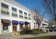
The easternmost portion near the Shops at Atlas Park is known as Upper Glendale and in general has more expensive homes and slightly higher income levels than the rest of Glendale.[10] Upper Glendale has detached single-family houses of above-average size, semi-detached wood frame houses and a number of brick townhomes with often meticulously maintained grassy front yards. Many of these were built after the 1920s.
The middle portion of Glendale that straddles Myrtle Avenue is the primary business district and has a mix of semi-detached, wood frame, single-family houses as well as a number of multi-family dwellings and townhomes. The housing stock here often dates back to the late 1800s/early 1900s and as a result, a significant number of them are made of yellow Kreischer brick much like similar, landmarked buildings in neighboring Ridgewood.
The western or "lower" part of Glendale has three national historic districts (see Architecture below) and includes the neighborhoods of Evergreen (near and around Evergreen Park) and Liberty Park, which is bordered by Cypress Hills Street, Cooper Avenue, 61st Street and cemeteries to the south. Like most of Glendale, Evergreen is relatively flat. It has mostly late 1800s/early 1900s semi-detached, multi-family, wood frame houses and a significant number of townhomes made of yellow Kreischer brick again similar to landmarked buildings in neighboring Ridgewood. In contrast, Liberty Park, developed in the 1920s, is built on the north slope of a hill and is dominated by detached single-family, wood-frame houses with private driveways and backyards.
Boundaries
Glendale is bordered to the north by a section of the Montauk Branch of the Long Island Rail Road (LIRR) in the western portion (Lower and Middle Glendale), and by Cooper and Metropolitan Avenues in the eastern portion (Upper Glendale). To the east, the border is the Rockaway Beach Branch of the LIRR, as well as Woodhaven Boulevard and Forest Park. Forest Park, along with the Jackie Robinson Parkway and a number of contiguous cemeteries, creates the southern and western borders; the borough line with Brooklyn runs through the cemeteries on the western part of the southern border. Glendale's borders are completed in the northwest (from Cooper and Wyckoff Avenues) by the Bay Ridge Branch of the LIRR.[3]
Architecture
In the lower portion of Glendale, just east of the Bushwick branch of the LIRR, three national historic districts were listed on the National Register of Historic Places in 1983.[12] These are the 75th Avenue-61st Street Historic District, Central Avenue Historic District and Cooper Avenue Row Historic District. Each of these districts contains significant numbers of early 20th century buildings made with the distinctive yellow Kreischer brick.
Parks
Myrtle Avenue was greatly enjoyed for its parks, often frequented by picnickers. With the steam trolley running along the Avenue, several investors bought a total of 500 acres (200 ha) of land in the eastern end of Glendale and opened a number of parks and beer gardens. In the 1890s, on the north side of Myrtle Avenue from what is now 83rd Street to Woodhaven Boulevard, Schmidt's Woods, Glendale Schuetzen Park, Greater New York Park and Casino, and Tivoli Park—all picnic parks—opened. On the south side of Myrtle Avenue from 88th Place to Woodhaven Boulevard were El Dorado Park, Emerald Park and Florida Park. These parks drew large crowds, not only from Glendale but from Eastern Brooklyn, where there were no proper parks at the time. One of the sections of Glendale, now known as "Liberty Park", is located on the site of a former beer garden of the same name. Another section of Glendale, adjacent to the LIRR Fresh Pond/Fremont Yards, was named after the Ivanhoe Park beer garden at that location. "Doddies", located at Cooper Avenue and 74th Street, was the last of the beer gardens, surviving into the late 1960s with an outdoor picnic area and the first neighborhood bar to have a television in the late 1940s or early 1950s. Redeemer Lutheran School occupies the site of "Hoffman Hall", a beer garden and dance hall. In the mid-1920s, the parks closed because they were unable to financially weather Prohibition.
From August 9, 1895 until 1898, one hundred and twenty-four parcels were bought for the new 538-acre (218 ha) Forest Park, which is composed of many of these former picnic parks. Since Brooklyn and Queens were incorporated into New York City by the time all of the park's land was procured, the park's name was shortened from the original moniker of "Brooklyn Forest Park". A bandstand built in Forest Park in 1898 preceded a bandshell built in 1920; for almost a century, George Seuffert Sr.—and later, his son, Dr. George F. Seuffert—played free concerts at the bandshell every weekend until the latter died in 1995. The bandstand is now for public use.[4] Forest Park also has a public golf course, as well as horse riding trails (stables are located nearby, off the park grounds). Forest Park Drive, which runs throughout the park, is closed to vehicles from Woodhaven Boulevard to Metropolitan Avenue, making it a popular spot for skaters.
Dry Harbor Playground, at Myrtle Avenue and 80th Street, opened in 1934. It has swings, seesaws, a wavy slide, a flagpole, and a school gym. It was created when Edward Bourcier gave away 17 acres (6.9 ha) of his land as part of Forest Park. The playground also consists of an attached one-story house.[4]
In 1940–1, the property of PS 67, as well as an adjoining lot, became the location of the Glendale Playground at Central Avenue and 70th Street. The playground opened in 1942.[4]
In 1949, a former Minor League Baseball field at 65th Place named Farmers’ Oval after the Glendale Farmers Base Ball Club team, which had played at the field for half a century prior, was the site of a groundbreaking for a new park. In 1967, the park was officially renamed the Joseph F. Mafera Park, memorializing the late Queens Borough president. At Mafera Park, roller hockey can be played on the rink there.[4]
On the easternmost edge of Glendale, on the site between the train tracks of the Rockaway Beach and Montauk Branches of the LIRR where an old ice house once stood, is Seither Stadium, the home field of the Ridgewood, Glendale, Middle Village and Maspeth Little League.
South of the Liberty Park section of Glendale (and separated by cemeteries as well as the Jackie Robinson Parkway) is Ridgewood Reservoir, a naturalistic part of Highland Park. The New York City government renovated it in 2013 by adding new period lighting and fences.
"Cemetery belt"
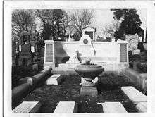
Within Glendale's "cemetery belt", the cemeteries that surround Glendale include Cypress Hills, Lutheran All Faiths, Salem Fields, Mount Lebanon, Mount Carmel, New Mount Carmel, Beth El (New Union Field), Mount Neboh, and Union Field. Some of these cemeteries are the resting places of many famous people, including Jackie Robinson, Mae West, and Harry Houdini, at whose tomb devotees gather each year on Halloween to see if he can pull off the ultimate escape trick and return from the grave. Cypress Hills Cemetery is the site of the New York City Police "Arlington" and also contains the graves of Confederate soldiers who died in local prisons and hospitals. It also was one of the earliest military cemeteries and its most unusual resident is a circus elephant.[6]
Education
Glendale is home to eight schools: P.S. 68 Elementary, P.S. 91 Elementary, P.S. 113 Elementary, I.S. 119 The Glendale Intermediate School, St. John's Lutheran Elementary, Sacred Heart Elementary, Redeemer Lutheran Elementary, and St. Pancras Elementary (which will close in June 2018).
Public safety
In 1896, Glendale's first fire department, the Ivanhoe Park Hose Company, a volunteer fire company, was established. It was funded by Henry Meyer, a wealthy businessman, who owned a cigar factory, a lucrative holding of stocks, and a sizable amount of land, part of which would become the neighborhood of Liberty Park. The fire department's uniforms, a hose cart and the hose were subsidized by Meyer. He also undertook several construction projects, such as building pumping stations, to ensure water would be available anywhere along the major streets (i.e., Myrtle Avenue and Cypress Hills Street). Later that year, the first company was expanded with a hook and ladder and renamed Ivanhoe Fire Hook and Ladder Company and two months later became Company 10 in the Newtown Fire Department.
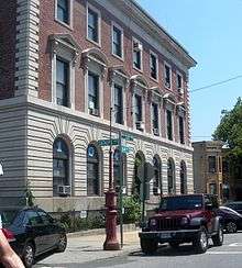
The neighborhood is now served by the New York City Fire Department's Engine Company #286 and Ladder Company #135, housed on the south side of Myrtle Avenue between 66th Place and 67th Street, in their original, historic building, erected in 1913 and by the 104th Police Precinct located on Catalpa Avenue at 64th Street.
Transportation
The closest subway stations to Glendale are Fresh Pond Road and Middle Village–Metropolitan Avenue, served by the M train, and Halsey Street, served by the L train.[13]
Glendale is served by the following bus routes, operated by MTA Regional Bus Operations:
- B13 local bus along Summerfield and Decatur Streets[14][15]
- Q11, Q21, Q52 SBS and Q53 SBS local buses and BM5, QM15, QM16, QM17 and QM18 express buses along Woodhaven Boulevard[14]
- Q23 local bus and QM12 and QM42 express buses along Woodhaven Boulevard and Union Turnpike[14]
- Q29 local bus along 80th Street[14]
- Q39 local bus along Forest Avenue[14]
- Q54 local bus along Metropolitan Avenue[14]
- Q55 local bus and QM24, QM25 and QM34 express buses along Myrtle Avenue[14]
The Long Island Rail Road had a station at Edsall Avenue and 73rd Street, which opened in 1868 and served the Montauk Branch. It closed on March 16, 1998, when it was closed due to low usage, with only two passengers a day using the stop.[16][17][18] The nearest operating LIRR stations are in Kew Gardens and Forest Hills.[14]
Notable people
Notable current and former residents of Glendale include:
- Richard Arkwright (1732-1792), a pioneer in the spinning industry, which revolutionized the knitwear industry. PS 91 in Glendale is named after him.
- Big Cass (born 1986), professional wrestler formerly with WWE.[19]
- Daniel Daly (1873-1937), the most decorated hero of the United States Marine Corps and Medal of Honor recipient, lived out his final years after World War I in Glendale.[20]
- Harry Houdini (1874-1926), magician, buried in Machpelah Cemetery
- Rafael Ramos (1974-2014), slain NYPD officer, who lived in Glendale before moving to Cypress Hills
- Phil Rizzuto (1917-2007), shortstop who spent his entire 13-year baseball career with the New York Yankees.[21]
- Dan Schneider (born 1965), writer
In popular culture
- In 1971, the sitcom All in the Family premiered. The house seen in the opening of the show is at 89-70 Cooper Avenue.[4]
- A Stranger Is Watching (1982) starring Rip Torn was filmed in a Glendale bar, The Woods, and most of the crew ate lunch with the owner at that time, John Virga.
- Part of an episode of NYPD Blue was also filmed at The Woods in the late 1990s.
- Another of Glendale's bars, The Assembly, figured prominently in the 1996 film Trees Lounge, written, directed, and starring Steve Buscemi. It served as the set for the fictional bar for which the movie is named.
- Cooper's Ale House (now "Yer Man's Irish Pub") is featured in the show The King of Queens as a local bar.[22]
See also
References
- 1 2 Table PL-P5 NTA: Total Population and Persons Per Acre - New York City Neighborhood Tabulation Areas*, 2010, Population Division - New York City Department of City Planning, February 2012. Accessed June 16, 2016.
- 1 2 Table PL-P3A NTA: Total Population by Mutually Exclusive Race and Hispanic Origin - New York City Neighborhood Tabulation Areas*, 2010, Population Division - New York City Department of City Planning, March 29, 2011. Accessed June 14, 2016.
- 1 2 3 Jackson, Kenneth T., ed. (1995), The Encyclopedia of New York City, New Haven: Yale University Press, ISBN 0300055366 , p.470
- 1 2 3 4 5 6 7 8 9 10 11 12 13 14 15 "History of Glendale". Glendale NY. Retrieved 8 June 2015.
- 1 2 Christina Wilkinson (March 2005). "HAVE YOU BEEN TO…GLENDALE?". Forgotten NY. Retrieved 8 June 2015.
- 1 2 "Glendale: A Quiet Enclave Residential Community with a Past". Daily News. New York. December 2, 1999. Archived from the original on July 14, 2011. Retrieved 2009-08-21.
- ↑ "Glendale's plea for own zip code denied". Daily News. New York. December 20, 2007. Retrieved 2014-01-28.
- ↑ "Pols appeal to USPS for Glendale zip". Glendale Register. New York. October 3, 2012. Retrieved 2014-02-02.
- ↑ "Queens Community Boards, New York City". Retrieved 2007-11-03.
- 1 2 3 4 Plambeck, Joseph (2011-11-23). "Glendale, Queens/Living In". The New York Times. Retrieved 2018-07-08.
- ↑ Media:Queens neighborhoods map.png
- ↑ National Park Service (2009-03-13). "National Register Information System". National Register of Historic Places. National Park Service.
- ↑ "Subway Map" (PDF). Metropolitan Transportation Authority. January 18, 2018. Retrieved January 18, 2018.
- 1 2 3 4 5 6 7 8 "Queens Bus Map" (PDF). Metropolitan Transportation Authority. December 2017. Retrieved April 24, 2018.
- ↑ "Brooklyn Bus Map" (PDF). Metropolitan Transportation Authority. November 2017. Retrieved April 24, 2018.
- ↑ Sengupta, Somini (March 15, 1998). "End of the Line for L.I.R.R.'s 10 Loneliest Stops". The New York Times. Retrieved 2009-08-07.
- ↑ Lyons, Richard D. (July 13, 1986). "If You're Thinking of Living In: Glendale". New York Times. Retrieved 18 October 2015.
- ↑ "Glendale SSRRLI Station; 1868-1998". arrts-arrchives.com. Retrieved May 28, 2017.
- ↑ Jones, James. [www.sunherald.com/sports/article184748518.html "A 7-foot tall WWE superstar stopped by the Coast this week. Here's why"], Sun Herald, November 15, 2017. Accessed June 26, 2018. "All eyes were on WWE superstar Big Cass as he entered Nezaty’s cafe in Gulfport Wednesday morning for an interview with the Sun Herald.... The Glendale Queens, N.Y., native’s top idols are 'Stone Cold' Steve Austin, Brock Lesnar, the Undertaker and Triple H."
- ↑ Bell, Bill. "Saluting The Past; Hero's grave inspires other vets", New York Daily News, November 13, 2000. Accessed August 20, 2017. "Like all Marines, Burke knows the details. Not only that, he lives across the street from the house in Glendale where Daly spent his last years and where he died."
- ↑ Barry, Ellen. "The Streets of Queens Where Rizzuto Played", The New York Times, August 16, 2007. Accessed June 26, 2018. "When Phil Rizzuto was a boy in Glendale, Queens, it was rare to get your hands on an actual baseball."
- ↑ "Filming locations for "The King of Queens" (1998)".
External links
| Wikimedia Commons has media related to Glendale, Queens. |
- Community Sketches for New York City
- Newsday Long Island History
- Answers.com: All in the Family
- Times Newsweekly of Ridgewood
- Profile of Glendale from the New York Times (subscription required) was