Batha, Lebanon
| Batha بطحا Batha' | |
|---|---|
| Municipality | |
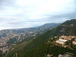 General view of Batha | |
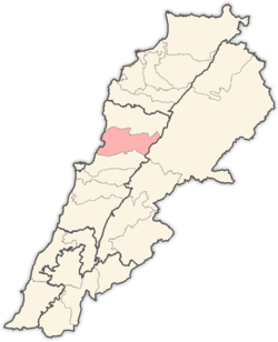
 Batha Location in Lebanon | |
| Coordinates: 33°59′17″N 35°39′33″E / 33.98806°N 35.65917°ECoordinates: 33°59′17″N 35°39′33″E / 33.98806°N 35.65917°E | |
| Country |
|
| Governorate | Mount Lebanon |
| District | Keserwan |
| Time zone | UTC+02 |
| Area code(s) | 09 |
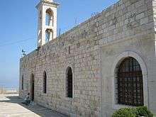
Church of Saint Nicholas in Batha

Batha as seen from Ghosta
Batha (Arabic: بطحا) is a village in the Keserwan District of the Mount Lebanon Governorate of Lebanon. It is located 28 kilometers northern the Lebanese capital Beirut,[1] and to the east of Jounieh Bay, with a view of the Mediterranean sea, with average elevation of 580 meters above sea level and total land area approximately 63 hectares.[1] A water spring flows through the pine and oak tree forests to the north of Batha, watering gardens and orchards before emptying in the Mediterranean sea. Principale families of Batha are El-Mir,Skayem,Oueiny,Mansour,Chayeb.
The inhabitants of the town are predominantly Maronite Catholics.[2] Batha is the hometown of Lebanese painter Michel Elmir (1930–1973).
References
- 1 2 "Batha". Localiban. Localiban. 2008-01-19. Retrieved 2009-07-24.
- ↑ "Elections municipales et ikhtiariah au Mont-Liban" (PDF). Localiban. Localiban. 2010. p. 19. Archived from the original (pdf) on 2015-07-24. Retrieved 2016-02-12.
This article is issued from
Wikipedia.
The text is licensed under Creative Commons - Attribution - Sharealike.
Additional terms may apply for the media files.