Jouret Bedran
| Jouret Bedran جورة بدران | |
|---|---|
| Municipality | |
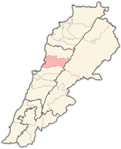
 Jouret Bedran Location in Lebanon | |
| Coordinates: 34°3′42″N 35°42′45″E / 34.06167°N 35.71250°E | |
| Country |
|
| Governorate | Mount Lebanon |
| District | Keserwan |
| Area | |
| • Total | 3 km2 (1.2 sq mi) |
| Elevation | 1,286 m (4,219 ft) |
| Time zone | UTC+2 (EET) |
| • Summer (DST) | UTC+3 (EEST) |
Jouret Bedran (Arabic: جورة بدران; also spelled Jurat Badran) is a village and municipality located in the Keserwan District of the Mount Lebanon Governorate in Lebanon. The village is 44 kilometres (27 mi) north of Beirut.[1] It has an average elevation of 1200 meters above sea level and a total land area of 120 hectares.Bordered by the famous jabal moussa from the right [1] Jouret Bedran's inhabitants are Maronites.[2] The major surname in the village is Ghanem.
References
- 1 2 "Jouret Bedrane". Localiban. Localiban. 2008-01-21. Retrieved 2009-07-24.
- ↑ "Elections municipales et ikhtiariah au Mont-Liban" (PDF). Localiban. Localiban. 2010. p. 19. Archived from the original (pdf) on 2015-07-24. Retrieved 2016-02-12.
This article is issued from
Wikipedia.
The text is licensed under Creative Commons - Attribution - Sharealike.
Additional terms may apply for the media files.