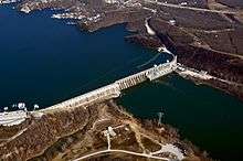
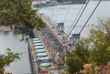
Bagnell Dam
| Bagnell Dam | |||||||||||||||||||||||
|---|---|---|---|---|---|---|---|---|---|---|---|---|---|---|---|---|---|---|---|---|---|---|---|
 Bagnell Dam | |||||||||||||||||||||||
| Country | United States | ||||||||||||||||||||||
| Location | Missouri | ||||||||||||||||||||||
| Coordinates | 38°12′08″N 92°37′37″W / 38.20222°N 92.62694°WCoordinates: 38°12′08″N 92°37′37″W / 38.20222°N 92.62694°W | ||||||||||||||||||||||
| Purpose | Hydroelectric | ||||||||||||||||||||||
| Construction began | 1929 | ||||||||||||||||||||||
| Opening date | 1931 | ||||||||||||||||||||||
| Owner(s) | AmerenUE | ||||||||||||||||||||||
| Dam and spillways | |||||||||||||||||||||||
| Type of dam | Concrete gravity | ||||||||||||||||||||||
| Impounds | Osage River | ||||||||||||||||||||||
| Height (foundation) | 148 ft (45 m)[1] | ||||||||||||||||||||||
| Length | 2,543 ft (775 m)[1] | ||||||||||||||||||||||
| Spillway type | Gated overflow[1] | ||||||||||||||||||||||
| Reservoir | |||||||||||||||||||||||
| Creates | Lake of the Ozarks | ||||||||||||||||||||||
| Total capacity | 1,927,000 acre⋅ft (2.377 km3)[2] | ||||||||||||||||||||||
| Active capacity | 468,000 acre⋅ft (0.577 km3)[3] | ||||||||||||||||||||||
| Catchment area | 13,944 sq mi (36,110 km2)[3] | ||||||||||||||||||||||
| Surface area | 54,000 acres (22,000 ha)[3] | ||||||||||||||||||||||
| Normal elevation | 660 ft (200 m) max[3] | ||||||||||||||||||||||
| Osage Powerplant | |||||||||||||||||||||||
| Type | Conventional | ||||||||||||||||||||||
| Hydraulic head | 90 ft (27 m)[3] | ||||||||||||||||||||||
| Turbines |
Main: 8x 21.5 MW (33,500 HP) Francis [1] Station service: 2x 2.0 MW (3,025 HP) Francis[3] | ||||||||||||||||||||||
| Installed capacity |
176.0 MW[1] 220 MW (overload)[3] | ||||||||||||||||||||||
| Annual generation | 957,340,000 KWh[4] | ||||||||||||||||||||||
| |||||||||||||||||||||||

Bagnell Dam impounds the Osage River in the U.S. state of Missouri, creating the Lake of the Ozarks. The 148-foot (45 m) tall concrete gravity dam was built by the Union Electric Company (now AmerenUE) for the purpose of hydroelectric power generation as its Osage Powerplant. It is 2,543 feet (775 m) long, including a 520-foot (160 m) long spillway and a 511-foot (156 m) long power station. The facility with eight generators has a maximum capacity of 215 megawatts.
Etymology
The dam derives its name from Bagnell, Missouri at the dam site which preceded the dam. It in turn derives its name from William Bagnell, who platted the town in 1883.[6] A variant name is the "Osage Dam".[7]
Geography
The dam is located in the city of Lakeside in Miller County, near the Camden-Miller County line.
History
Construction started on the dam in 1929 and was completed in 1931. The resulting reservoir, the Lake of the Ozarks, has a surface area of 55,000 acres (22,000 ha), over 1,150 miles (1,850 km) of shoreline (1850 km), and stretches 94 miles (151 km) from end to end. At the time of construction, it was one of the largest man-made lakes in the world and the largest in the United States. Its construction virtually ended commercial traffic on the upper river.
The concept of a hydro-electric power plant on the Osage River was first introduced by a Kansas City developer as early as 1912. Ralph Street managed to put together the funding to construct a dam across the Osage River. He began building roads, railroads, and the support structures necessary to begin construction of a dam that would impound a much smaller lake than what is now known as Lake of the Ozarks. Sometime in the mid-1920s, Street’s funding dried up, and he had to abandon the idea of the first hydroelectric power plant on the Osage River.
Union Electric Power and Light stepped in with engineering firm Stone & Webster from Boston, Massachusetts. It designed and constructed Bagnell Dam in one of the most unlikely spots along the Osage River. Many thought the $30 million project would be a disaster after the stock market crash of 1929, but it was completed. Employment during the lengthy construction proved to be a boost to many families in the area, as well as the hundreds of workers attracted from other areas of the country. By early21st-century standards, all construction was done by hand, and the equipment used in the construction was quite primitive. The construction of Bagnell Dam was completed and Lake of the Ozarks was a full reservoir in fewer than two years.[8]
The stock market crash of 1929, which precipitated the Great Depression, occurred just months after construction began on Bagnell Dam. The project employed thousands of laborers, providing a large economic boost to the rural area around the dam and to the state as a whole at a time when jobs were scarce.
The associated Union Electric Administration Building-Lakeside was constructed in 1930. This building was added to the National Register of Historic Places in 1998, with a boundary increase of associated property in 2011.[5][9]
Floodgates
Construction of the dam allowed for thirteen floodgates, as called for in the original design. Only twelve floodgates were installed, and the thirteenth spillway opening is walled shut with concrete. The engineers calculated that twelve floodgates provided a large enough margin of safety.
Taum Sauk pumped storage plant
AmerenUE remotely operates the Taum Sauk pumped storage plant from its control room at Bagnell Dam.
References
- 1 2 3 4 5 "Bagnell Dam Facts and Figures". The Lake Area History Pages. Retrieved 2016-02-24.
- ↑ "Hydrology". Missouri Department of Conservation. Retrieved 2016-02-24.
- 1 2 3 4 5 6 7 "Bagnell Dam and Osage Power Plant: Osage Power Plant Station" (PDF). Historic American Engineering Record. U.S. Library of Congress. Retrieved 2016-02-24.
- ↑ "Osage (2106)". Carbon Monitoring for Action. Retrieved 2016-02-24.
- 1 2 National Park Service (2010-07-09). "National Register Information System". National Register of Historic Places. National Park Service.
- ↑ The Story Of Bagnell
- ↑ U.S. Geological Survey Geographic Names Information System: Bagnell Dam
- ↑ Lake of the Ozarks, Missouri, the premier vacation spot in the Midwest
- ↑ "National Register of Historic Places Listings". Weekly List of Actions Taken on Properties: 6/20/11 through 6/24/11. National Park Service. 2011-07-01.
- "Osage Power Plant". Ameren. Archived from the original on 23 February 2005. Retrieved February 25, 2005.
- "Watershed, Niangua River, Hydrology Chapter". Missouri Department of Conservation's Missouri's Rivers and Their Watersheads Homepage. Archived from the original on 17 March 2005. Retrieved February 25, 2005.
- "Bagnell Dam". Geographic Names Information System. United States Geological Survey. Retrieved 2006-05-12.
- "Osage Dam". Geographic Names Information System. United States Geological Survey. Retrieved 2006-05-12.
- Map of Bagnell Dam area

