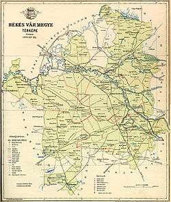
Békés County
| Békés County Békés megye | |||
|---|---|---|---|
| Counties of Hungary | |||
   | |||
| |||
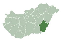 Békés County within Hungary | |||
| Country |
| ||
| Region | Southern Great Plain | ||
| County seat | Békéscsaba | ||
| Districts | |||
| Government | |||
| • President of the General Assembly | Mihály Zalai (Fidesz-KDNP) | ||
| Area | |||
| • Total | 5,629.71 km2 (2,173.64 sq mi) | ||
| Area rank | 7th in Hungary | ||
| Population (2015) | |||
| • Total | 351,148[1] | ||
| • Rank | 11th in Hungary | ||
| Postal code | 55xx – 59xx | ||
| Area code(s) | (+36) 66, 68 | ||
| ISO 3166 code | HU-BE | ||
| Website |
www | ||
Békés (Hungarian: Békés megye, pronounced [ˈbeːkeːʃ], Romanian: Județul Bichiș), is an administrative division (county or megye) in south-eastern Hungary, on the border with Romania. It shares borders with the Hungarian counties Csongrád, Jász-Nagykun-Szolnok, and Hajdú-Bihar. The capital of Békés county is Békéscsaba. The county is also part of the Danube-Kris-Mures-Tisa euroregion.
Etymology
In Slovak, it is known as Békešská župa and in Romanian as Județul Bichiș.
After Hungarians conquered the area, Békés and its surroundings were the property of the Csolt clan. Békés (the name means "peaceful") was originally the name of the castle which gave its name to the comitatus, and, like many castles, was possibly named after its first steward.
Geography
This county has a total area of 5,630 km2 (2,174 sq mi) – 6,05% of Hungary.
Békés county lies on the Pannonian Plain (Great Plain), it is a flat area with good soil. Average rainfall is 645 mm/year. One-fifth of the natural gas resources of Hungary can be found in Békés. The river Körös runs through the county.
Neighbours
- Hajdú-Bihar County in the North.

- Csongrád and Jász-Nagykun-Szolnok County in the West.
History
The area has been inhabited since 5000-4000 BC. Before the arrival of the Hungarians several other tribes lived in the area.
The castle of Gyula was built in the early 15th century. Gyula was the most significant town of the county at that time, and became county seat under Matthias I. It was an important fortress during the Ottoman wars in Europe but it was captured in 1566. During this time, several towns were destroyed in the area.
In the early 18th century, after the Ottomans were expelled, the county was repopulated, not only with Hungarians, but with Slovaks (in the towns Békéscsaba, Endrőd, Szarvas, Tótkomlós), Serbs (Battonya), Germans (Németgyula, Elek), and Romanians (Kétegyháza). Most of the non-Magyar population was assimilated by the mid-19th century.
The agricultural importance of the county and the new railway line between Pest and Békéscsaba (finished in 1858) brought development, which was quickened when Hungary lost its southern territories to Romania after World War I and Békéscsaba had to take over the role of the lost cities.
The population growth peaked in 1950 (472,000), in the same year when Békéscsaba became the county seat. During the following years, the county was industrialized, like most of Hungary, and the population of the cities and towns grew.
Demographics
Religion in Békés County (2011 census)
In 2015, it had a population of 351,148 and the population density was 62/km².
More than 60% of the population lives in towns.
| Year | County population[2] | Change |
|---|---|---|
| 1949 | 471,561 | n/a |
| 1960 | -0.78% | |
| 1970 | -6.17% | |
| 1980 | -0.47% | |
| 1990 | -5.73% | |
| 2001 | -3.42% | |
| 2011 | -9.51% |
Ethnicity
Besides the Hungarian majority, the main minorities are the Roma (approx. 9,500), Slovak (7,500), Romanian (5,000), German (2,500) and Serb (500).
Total population (2011 census): 359,948
Ethnic groups (2011 census):[3]
Identified themselves: 325,597 persons:
- Hungarians: 300,213 (92.20%)
- Gypsies: 9,290 (2.85%)
- Slovaks: 7,267 (2.23%)
- Romanians: 5,137 (1.58%)
- Others and indefinable: 3,690 (1.13%)
Approx. 53,000 persons in Békés County did not declare their ethnic group at the 2011 census.
Religion
Religious adherence in the county according to 2011 census:[4]
- Catholic – 70,307 (Roman Catholic – 69,478; Greek Catholic – 809);
- Reformed – 46,366;
- Evangelical – 27,870;
- Orthodox – 3,491;
- Other religions – 6,936;
- Non-religious – 113,094;
- Atheism – 4,150;
- Undeclared – 87,734.
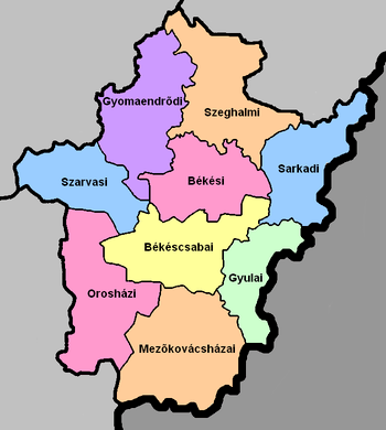
Regional structure
| № | English and Hungarian names |
Area (km²) |
Population (2011) |
Density (pop./km²) |
Seat | № of municipalities |
| 1 | Békéscsaba District Békéscsabai járás |
636.16 | 83,541 | 131 | Békéscsaba | 9 |
| 2 | Békés District Békési járás |
525.24 | 37,409 | 71 | Békés (town) | 7 |
| 3 | Gyomaendrőd District Gyomaendrődi járás |
686.21 | 23,943 | 35 | Gyomaendrőd | 5 |
| 4 | Gyula District Gyulai járás |
413.22 | 41,627 | 101 | Gyula | 4 |
| 5 | Mezőkovácsháza District Mezőkovácsházai járás |
881.49 | 40,550 | 46 | Mezőkovácsháza | 18 |
| 6 | Orosháza District Orosházi járás |
717.18 | 51,482 | 72 | Orosháza | 8 |
| 7 | Sarkad District Sarkadi járás |
570.97 | 22,908 | 40 | Sarkad | 11 |
| 8 | Szarvas District Szarvasi járás |
485.06 | 28,779 | 59 | Szarvas | 6 |
| 9 | Szeghalom District Szeghalmi járás |
714.19 | 29,709 | 42 | Szeghalom | 7 |
| Békés County | 5,629.71 | 359,948 | 64 | Békéscsaba | 75 | |
|---|---|---|---|---|---|---|
Politics
The Békés County Council, elected at the 2014 local government elections, is made up of 18 counselors, with the following party composition:[5]
| Party | Seats | Current County Assembly | |||||||||||
|---|---|---|---|---|---|---|---|---|---|---|---|---|---|
| Fidesz-KDNP | 11 | ||||||||||||
| Movement for a Better Hungary (Jobbik) | 4 | ||||||||||||
| Hungarian Socialist Party (MSZP) | 2 | ||||||||||||
| Democratic Coalition (DK) | 1 | ||||||||||||
Presidents of the General Assembly
| List of Presidents, from 1990[6] | |
|---|---|
| Mihály Zalai (Fidesz-KDNP) | 2014– |
Municipalities
Békés County has 1 urban county, 21 towns, 8 large villages and 45 villages.
The regional structure of Békés county is typical of the Great Plain: it has a small number of villages, but those are large, both by area and by population. There are several farmsteads as well. 70% of the population lives in cities and towns, while 17% are in the county seat. A large village network is characteristic of the county which currently has 75 administratively independent settlements, of which 19 are cities and 56 are villages. The oldest towns, and with the largest populations, are: Békéscsaba, the county seat - a city carrying a rank of county right, Orosháza, Gyula, Békés, and Szarvas.
- City with county rights
(ordered by population, as of 2011 census)
- Békéscsaba (62,050) – county seat
- Towns
- Gyula (31,067)
- Orosháza (29,081)
- Békés (20,088)
- Szarvas (16,956)
- Gyomaendrőd (13,680)
- Mezőberény (10,632)
- Sarkad (10,020)
- Szeghalom (9,290)
- Dévaványa (7,899)
- Vésztő (6,986)
- Mezőkovácsháza (6,177)
- Battonya (6,042)
- Tótkomlós (6,016)
- Füzesgyarmat (5,734)
- Mezőhegyes (5,712)
- Kondoros (5,228)
- Újkígyós (5,196)
- Csorvás (5,060)
- Elek (4,927)
- Körösladány (4,674)
- Medgyesegyháza (3,698)
- Villages
- Almáskamarás
- Békéssámson
- Békésszentandrás

- Bélmegyer
- Biharugra
- Bucsa
- Csabacsűd
- Csabaszabadi
- Csanádapáca
- Csárdaszállás
- Doboz
- Dombegyház
- Dombiratos
- Ecsegfalva
- Gádoros
- Gerendás
- Geszt
- Hunya
- Kamut
- Kardos
- Kardoskút
- Kaszaper
- Kertészsziget
- Kevermes
- Kétegyháza
- Kétsoprony
- Kisdombegyház
- Körösnagyharsány
- Köröstarcsa
- Körösújfalu
- Kötegyán
- Kunágota
- Lőkösháza
- Magyarbánhegyes
- Magyardombegyház
- Medgyesbodzás
- Mezőgyán
- Méhkerék
- Murony
- Nagybánhegyes
- Nagykamarás
- Nagyszénás
- Okány
- Örménykút
- Pusztaföldvár
- Pusztaottlaka
- Sarkadkeresztúr
- Szabadkígyós
- Tarhos
- Telekgerendás
- Újszalonta
- Végegyháza
- Zsadány
![]()
Gallery
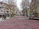
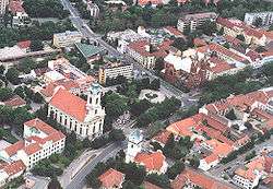
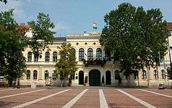 Békéscsaba, the capital of the county
_2.jpg)
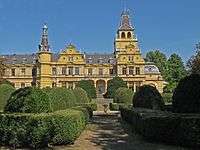 Wenckheim Mansion in Szabadkígyós
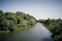
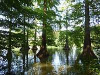 Taxodium in the River Körös
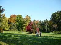
.jpg) Batthyány Mansion's park in Kondoros
Batthyány Mansion's park in Kondoros.jpg) Tavern in Kondoros
Tavern in Kondoros- Arboretum in Szarvas
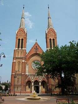 Roman Catholic Church of Békéscsaba
Notable people
Natives of the county include:
- Vilmos Apor, Bishop of Győr
- Endre Bajcsy-Zsilinszky, politician and an important voice
- Zoltán Lajos Bay, physicist, professor, and engineer
- András Balczó, modern pentathlete (olympic champion)
- Béla H. Bánáthy, founder of the White Stag Leadership Development Program
- Ferenc Berényi, painter
- Imre Bródy, physicist
- József Darvas, politician, Minister of Religion and Education (1950-51)
- Albrecht Dürer the Elder, goldsmith in Nuremberg
- Ferenc Erkel, composer, conductor and pianist, father of Hungarian grand opera
- Ágnes Gergely, writer, educator, journalist and translator
- János Jankó, painter and graphicist
- Ferenc Kállai, actor
- István Kiss, architect
- László Krasznahorkai, novelist and screenwriter
- Gyula Kristó, historian
- Menyhért Lakatos, writer
- Gyula Lázár, footballer
- Soma Orlai Petrich, painter
- Henrietta Ónodi, artistic gymnast
- Károly Palotai, association football player and referee
- János Pásztor, academic sculptor
- Paulina Pfiffner, freedom fighter in the Hungarian Revolution of 1848
- George Pomutz, officer during the Hungarian Revolution of 1848 and the American Civil War
- Frigyes Puja, politician, Minister of Foreign Affairs (1973-83)
- Emil Purgly, politician, Minister of Agriculture (1934)
- Kálmán Rózsahegyi, actor and teacher
- Mihály Schéner, sculptor, painter, graphic artist, and ceramist
- Árpád Szendy, pianist, composer and teacher
- Ferenc Szisz, race car driver
- Hajnalka Tóth, fencer (world champion)
- Béla Turi-Kovács, politician, Minister of the Environment (2000-02)
- Béla Wenckheim, politician, Prime Minister (1875)
- Pál Závada, writer
International relations
Békés County has a partnership relationship with:
|
|
References
| Wikimedia Commons has media related to Békés County. |
| Wikivoyage has a travel guide for Békés County. |
- ↑ nepesseg.com, population data of Hungarian settlements
- ↑ népesség.com, "Békés megye népessége 1870-2015"
- ↑ 1.1.6. A népesség anyanyelv, nemzetiség és nemek szerint – Frissítve: 2013.04.17.; Hungarian Central Statistical Office (in Hungarian)
- ↑ 2011. ÉVI NÉPSZÁMLÁLÁS, 3. Területi adatok, 3.4 Békés megye, (in Hungarian)
- ↑ A közgyűlés felépítése, (in Hungarian)
- ↑ Önkormányzati választások eredményei (in Hungarian)
External links
- Official site in Hungarian, German, English, Slovak and Romanian
- Békés Megyei Hírlap (beol.hu) - The county portal
- Hungary at GeoHive
- Roaming in Békés County free guide 2010 Published by Békés County Government Text by Barát Tünde
Coordinates: 46°44′15″N 21°2′41″E / 46.73750°N 21.04472°E
| City with county rights |
|  |
|---|---|---|
| Towns | ||
| Large villages | ||
| Villages |
| |
| Other topics |
| |