Kardoskút
| Kardoskút | |||
|---|---|---|---|
| |||
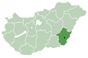 Location of Békés County in Hungary | |||
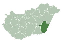
 Kardoskút Location within Hungary | |||
| Coordinates: 46°29′N 20°40′E / 46.483°N 20.667°E | |||
| Country |
| ||
| County | Békés | ||
| Area | |||
| • Total | 76.58 km2 (29.57 sq mi) | ||
| Population (2015) | |||
| • Total | 913[1] | ||
| Time zone | UTC+1 (CET) | ||
| • Summer (DST) | UTC+2 (CEST) | ||
| Postal code | 5945 | ||
| Area code(s) | (+36) 68 | ||
| Website |
www | ||

Kardoskút is a village in Békés County, in the Southern Great Plain region of south-east Hungary.
Geography
It covers an area of 76.58 km2 (29.57 sq mi) and has a population of 913 people (2015).[1]
References
- 1 2 Gazetteer of Hungary, 1st January 2015. Hungarian Central Statistical Office. 03/09/2015
| City with county rights |
|   |
|---|---|---|
| Towns | ||
| Large villages | ||
| Villages |
| |
| Other topics |
| |
This article is issued from
Wikipedia.
The text is licensed under Creative Commons - Attribution - Sharealike.
Additional terms may apply for the media files.