Battonya
| Battonya | ||
|---|---|---|
| Town | ||
 Aerial photography: Battonya - Temple | ||
| ||
 Battonya | ||
| Coordinates: 46°17′N 21°1′E / 46.283°N 21.017°E | ||
| Country |
| |
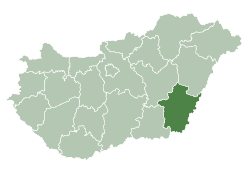
| County | Békés | |
| District | Mezőkovácsháza | |
| Area | ||
| • Total | 145.77 km2 (56.28 sq mi) | |
| Population (2015) | ||
| • Total | 5,960[1] | |
| • Density | 46.34/km2 (120.0/sq mi) | |
| Time zone | UTC+1 (CET) | |
| • Summer (DST) | UTC+2 (CEST) | |
| Postal code | 5830 | |
| Area code | (+36) 68 | |
| Website |
www | |

Battonya (Romanian: Bătania, Serbian: Батања, translit. Batanja) is a town in Békés County, in the Southern Great Plain region of south-east Hungary. Residents are Magyars, with minority of Serbs.
Geography
It covers an area of 145.77 km² and has a population of 5960 people (2015).
History
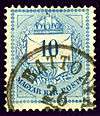
Kingdom of Hungary stamp, issue 1874, cancelled at BATTONYA.
After the Ottoman occupation until 1918, BATTONYA was part of the Austrian monarchy, province of Hungary;[2] in Transleithania after the compromise of 1867 in the Kingdom of Hungary.
Twin towns – sister cities
Battonya is twinned with:
References
- ↑ Gazetteer of Hungary, 1st January 2015. Hungarian Central Statistical Office. 03/09/2015
- ↑ Handbook of Austria and Lombardy-Venetia Cancellations on the Postage Stamp Issues 1850-1864, by Edwin MUELLER, 1961.
External links
| Wikimedia Commons has media related to Battonya. |
- Official website in Hungarian
| Towns (4) |
| |
|---|---|---|
| Large villages (2) | ||
| Villages (12) | ||
| City with county rights |
|   |
|---|---|---|
| Towns | ||
| Large villages | ||
| Villages |
| |
| Other topics |
| |
Coordinates: 46°17′N 21°01′E / 46.283°N 21.017°E
This article is issued from
Wikipedia.
The text is licensed under Creative Commons - Attribution - Sharealike.
Additional terms may apply for the media files.