Békéscsaba District
| Békéscsaba District Békéscsabai járás | |||
|---|---|---|---|
| Districts of Hungary | |||
| |||
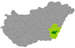 Békéscsaba District within Hungary and Békés County. | |||
| Country |
| ||
| County | Békés | ||
| District seat | Békéscsaba | ||
| Area | |||
| • Total | 636.16 km2 (245.62 sq mi) | ||
| Area rank | 5th in Békés | ||
| Population (2011 census) | |||
| • Total | 83,541 | ||
| • Rank | 1st in Békés | ||
| • Density | 131/km2 (340/sq mi) | ||


Békéscsaba (Hungarian: Békéscsabai járás) is a district in central-southern part of Békés County. Békéscsaba is also the name of the town where the district seat is found. The district is located in the Southern Great Plain Statistical Region.
Geography
Békéscsaba District borders with Békés District to the north, Sarkad District and Gyula District to the east, Mezőkovácsháza District to the south, Orosháza District and Szarvas District to the west. The number of the inhabited places in Békéscsaba District is 9.
Municipalities
The district has 1 urban county, 2 towns, 1 large village and 5 villages. (ordered by population, as of 1 January 2012)[1]
- Békéscsaba (63,752) – district and county seat
- Csabaszabadi (335)
- Csorvás (4,981)
- Doboz (4,167)
- Gerendás (1,311)
- Kétsoprony (1,428)
- Szabadkígyós (2,696)
- Telekgerendás (1,549)
- Újkígyós (5,235)
The bolded municipalities are cities, italics municipality is large village.
Demographics
Religion in Békéscsaba District (2011 census)
In 2011, it had a population of 83,541 and the population density was 131/km².
| Year | County population[2] | Change |
|---|---|---|
| 2011 | 83,541 | n/a |
Ethnicity
Besides the Hungarian majority, the main minorities are the Slovak (approx. 3,500), Roma (900), Romanian (500) and German (450).
Total population (2011 census): 83,541
Ethnic groups (2011 census):[3] Identified themselves: 78,408 persons:
- Hungarians: 72,018 (91.85%)
- Slovaks: 3,504 (4.47%)
- Gypsies: 916 (1.17%)
- Others and indefinable: 1,970 (2.51%)
Approx. 5,000 persons in Békéscsaba District did not declare their ethnic group at the 2011 census.
Religion
Religious adherence in the county according to 2011 census:[4]
- Catholic – 17,821 (Roman Catholic – 17,627; Greek Catholic – 184);
- Evangelical – 9,444;
- Reformed – 6,031;
- Orthodox – 149;
- other religions – 1,404;
- Non-religious – 26,364;
- Atheism – 1,289;
- Undeclared – 21,039.
Gallery
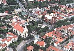 Békéscsaba, the district seat
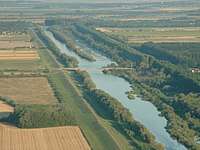 Bridge over Kettős-Körös near Doboz
 Winter landscape near Csorvás
.jpg) Wenckheim Mansion in Szabadkígyós
Wenckheim Mansion in Szabadkígyós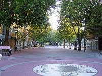 Downtown of Békéscsaba
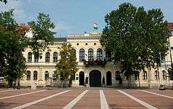 Town Hall in Békéscsaba
 Élővíz Canal in Békéscsaba
.JPG) Jókai Theater (Békéscsaba)
Jókai Theater (Békéscsaba)
See also
References
- ↑ A KSH 2012. évi helységnévkönyve
- ↑ népesség.com, "Békéscsabai járás népessége"
- ↑ 4.1.6.1 A népesség nemzetiség szerint, 2011, (in Hungarian)
- ↑ 4.1.7.1 A népesség vallás, felekezet szerint, 2011, (in Hungarian)
External links
| City with county rights (1) |
| |
|---|---|---|
| Towns (2) | ||
| Large village (1) | ||
| Villages (5) | ||