Avondale, Arizona
| Avondale, Arizona | |
|---|---|
| City | |
 Entrance to the town of Avondale | |
 Location of Avondale in Maricopa County, Arizona. | |
 Avondale, Arizona Location in the United States | |
| Coordinates: 33°26′01″N 112°20′59″W / 33.43361°N 112.34972°WCoordinates: 33°26′01″N 112°20′59″W / 33.43361°N 112.34972°W | |
| Country | United States |
| State | Arizona |
| County | Maricopa |
| Government | |
| • Mayor | Kenn Weise |
| Area[1] | |
| • Total | 45.32 sq mi (117.38 km2) |
| • Land | 45.25 sq mi (117.19 km2) |
| • Water | 0.07 sq mi (0.19 km2) |
| Elevation | 974 ft (297 m) |
| Population (2010)[2] | |
| • Total | 76,238 |
| • Estimate (2017)[3] | 84,025 |
| • Density | 1,856.95/sq mi (716.97/km2) |
| Time zone | UTC-7 (MST (no daylight saving time)) |
| ZIP code | 85323, 85392 |
| Area code(s) | 623 |
| FIPS code | 04-04720 |
| Website | http://www.ci.avondale.az.us/ |
Avondale is a city in Maricopa County, Arizona, United States, adjacent to Phoenix. According to the 2010 census, the population of the city is 76,238.[2]
Avondale, incorporated in 1946, experienced rapid residential and commercial growth in the years since 1980. Once primarily a sparsely populated farming community with many acres of alfalfa and cotton fields, Avondale has transformed into a major bedroom suburb for Phoenix. Several major residential subdivisions and shopping centers have recently been built on former farmland, many adjacent to Interstate 10.
Phoenix Children's Hospital has a satellite facility (the Southwest Valley Urgent Care Center), at the corner of Avondale Boulevard and McDowell Road.
Geography
Avondale is located at 33°26′01″N 112°20′59″W / 33.43361°N 112.34972°W (33.435322, −112.349758).[4]
According to the United States Census Bureau, the city has a total area of 41.3 square miles (107 km2), of which, 41.3 square miles (107 km2) of it is land and 0.1 square miles (0.26 km2) of it (0.15%) is water.
Demographics
As of the census of 2000, there were 35,883 people, 10,640 households, and 8,724 families residing in the city. The population density was 869.7 people per square mile (335.8/km²). There were 11,419 housing units at an average density of 276.8 per square mile (106.9/km²). The racial makeup of the city was 63.27% White, 5.20% Black or African American, 1.28% Native American, 1.89% Asian, 0.14% Pacific Islander, 24.32% from other races, and 3.89% from two or more races. 46.23% of the population were Hispanic or Latino of any race.
There were 10,640 households out of which 47.9% had children under the age of 18 living with them, 62.9% were married couples living together, 12.7% had a female householder with no husband present, and 18.0% were non-families. 12.9% of all households were made up of individuals and 3.1% had someone living alone who was 65 years of age. The average household size was 3.36 and the average family size was 3.66.
In the city, the population was spread out with 34.2% under the age of 18, 9.7% from 18 to 24, 33.1% from 25 to 44, 17.7% from 45 to 64, and 5.3% who were 65 years of age or older. The median age was 29 years. For every 100 females, there were 102.4 males. For every 100 females age 18 and over, there were 101.1 males.
The median income for a household in the city was $49,153, and the median income for a family was $51,084. Males had a median income of $35,134 versus $27,487 for females. The per capita income for the city was $16,919. About 10.3% of families and 13.8% of the population were below the poverty line, including 17.2% of those under age 18 and 16.7% of those age 65 or over.
In 2010 Avondale had a population of 78,256. The racial and ethnic composition of the population was 50.3% Hispanic or Latino, 34.0% non-Hispanic white, 9.3% black or African American, 1.7% Native American, 3.5% Asian, 0.4% Pacific Islander, 0.2% non-Hispanic of some other race and 4.5% reporting two or more races.[5]
| Historical population | |||
|---|---|---|---|
| Census | Pop. | %± | |
| 1950 | 2,505 | — | |
| 1960 | 6,151 | 145.5% | |
| 1970 | 6,626 | 7.7% | |
| 1980 | 8,168 | 23.3% | |
| 1990 | 16,169 | 98.0% | |
| 2000 | 35,883 | 121.9% | |
| 2010 | 76,238 | 112.5% | |
| Est. 2017 | 84,025 | [3] | 10.2% |
| U.S. Decennial Census[6] | |||
Governmental representation
Avondale falls within Arizona's 3rd Congressional District, served by Representative Raúl Grijalva and Arizona's 19th State Legislative District, served by Representatives Mark A. Cardenas and Diego Espinoza and Senator Lupe Contreras, all Democrats.
Climate
Avondale has a large amount of sunshine year round due to its stable descending air and high pressure. According to the Köppen Climate Classification system, the city has a Hot desert climate, abbreviated "Bwh" on climate maps.[7]
Winters are sunny and mild with nighttime lows averaging between 40 °F (4 °C) and 50 °F (4 °C and 10 °C) and daytime highs ranging from 60 °F (16 °C) to 75 °F (16 °C to 24 °C). The record low temperature recorded in Avondale is 16 °F (−9 °C). Summers are extremely hot, with daily high temperatures at or above 100 °F (38 °C) for the entirety of June, July, and August, as well as many days in May and September. An occasional heat wave will spike temperatures over 115 °F (46 °C) briefly. Nighttime lows in the summer months average between 70 °F (21 °C) and 80 °F (21 °C and 27 °C), with an occasional overnight low above 80 °F (27 °C) not uncommon. Avondale's record high temperature stands at an impressive 125 °F (52 °C), a few degrees warmer than the record for Phoenix, and just 3 °F (−16 °C) shy of Arizona's state record of 128 °F (53 °C), recorded in Lake Havasu City on June 29, 1994.
Snow is rare in the area, occurring once every several years. Lows in the winter occasionally dip below freezing, which may damage some desert plants such as saguaros and other cacti. In the summer (mainly July, August and early September), the North American Monsoon can hit the Phoenix area in the afternoon and evening (possibly continuing overnight), causing rain showers even from a sunny morning. Dust storms are occasional, mainly during the summer.
| Climate data for Avondale, Arizona | |||||||||||||
|---|---|---|---|---|---|---|---|---|---|---|---|---|---|
| Month | Jan | Feb | Mar | Apr | May | Jun | Jul | Aug | Sep | Oct | Nov | Dec | Year |
| Record high °F (°C) | 89 (32) |
93 (34) |
100 (38) |
105 (41) |
115 (46) |
125 (52) |
125 (52) |
120 (49) |
116 (47) |
109 (43) |
98 (37) |
89 (32) |
125 (52) |
| Average high °F (°C) | 65 (18) |
70 (21) |
76 (24) |
85 (29) |
94 (34) |
103 (39) |
105 (41) |
103 (39) |
98 (37) |
87 (31) |
74 (23) |
64 (18) |
85 (30) |
| Average low °F (°C) | 42 (6) |
45 (7) |
50 (10) |
56 (13) |
64 (18) |
72 (22) |
79 (26) |
79 (26) |
72 (22) |
59 (15) |
48 (9) |
41 (5) |
59 (15) |
| Record low °F (°C) | 16 (−9) |
22 (−6) |
22 (−6) |
27 (−3) |
36 (2) |
49 (9) |
57 (14) |
50 (10) |
44 (7) |
31 (−1) |
22 (−6) |
20 (−7) |
16 (−9) |
| Average precipitation inches (mm) | 0.99 (25.1) |
1.28 (32.5) |
0.97 (24.6) |
0.37 (9.4) |
0.11 (2.8) |
0.04 (1) |
0.83 (21.1) |
1.23 (31.2) |
0.95 (24.1) |
0.49 (12.4) |
0.68 (17.3) |
0.99 (25.1) |
8.93 (226.8) |
| Source: The Weather Channel[8] | |||||||||||||
Notable people
- Mitch Garcia – professional soccer player, graduated from Agua Fria High School.
- Shawn Gilbert – professional baseball player; played high school baseball at Agua Fria High School.
- Everson Griffen – defensive end for USC Trojans and Minnesota Vikings; attended Agua Fria High School.
- Nick Harris – punter for NFL's Detroit Lions; attended Westview High School.
- Drisan James – wide receiver for CFL's Hamilton Tiger-Cats; attended Westview High School.
- Craig Mabbitt – vocalist for band Escape The Fate and former vocalist for bands blessthefall and The Word Alive; attended Westview High School.
- Randall McDaniel – former NFL offensive guard, inducted into National Football Foundation College Hall of Fame in 2008 and Pro Football Hall of Fame in 2009; he was a sprinter at Agua Fria High School.[9]
- Clancy Pendergast – defensive coordinator of Kansas City Chiefs.
- Raymond H. Shuey – retired chief financial officer, finance director, and treasurer for Glendale, Arizona.
- Shelley Smith – professional football player[10]
Education
Avondale is served by the Littleton Elementary District, the Avondale Elementary District, and the Agua Fria Union High School District. Westview High School, La Joya Community High School, and Agua Fria High School are the high schools in the city. Estrella Mountain Community College, established in 1992, is located in the city. Another college is Universal Technical Institute.
Sports
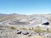
Avondale is home to ISM Raceway. It holds two Monster Energy NASCAR Cup Series races, two Xfinity Series races, and a Camping World Truck Series race annually.
The City of Avondale Parks and Recreation Department offers quality sports for both youth and adults.[11]
City Parks
- Las Ligas
12421 W Lower Buckeye Road
- Festival Fields
101 E. Lower Buckeye
- Donnie Hale Park
10857 West Pima St.
- Friendship Park / Dog Park
12325 West McDowell
- Mountain view
201 E Mountain View Drive[12]
- Sernas Plaza
521 E Western Ave
- Fred Campbell
101 E Lawrence Blvd
- Dennis DeConcini
351 E Western Ave
- Dessie Lorenz
202 E Main St
- Doc Rhodes Park
104 W Western Ave
Gila and Salt River Meridan
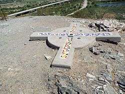
The surveying marker of the Gila and Salt River Meridan is located on Monument Hill. Ever since 1851, this has been the center point used by the state to measure the land in Arizona. The federal government recognized this point for measuring the boundary between the United States and Mexico after the Mexican–American War ended. The first survey conducted in 1867, involved the first 36 miles (58 km) of Arizona. Up until 1874, this was the epicenter of all surveying in Arizona for property deeds. It was listed in the National Register of Historic Places on October 15, 2002, Reference #02001137. Monument Hill is located at 115th Avenue and Baseline Road in Avondale.[13]
See also
References
- ↑ "2017 U.S. Gazetteer Files". United States Census Bureau. Retrieved August 7, 2018.
- 1 2 "American FactFinder". United States Census Bureau. Retrieved June 18, 2012.
- 1 2 "Population and Housing Unit Estimates". Retrieved March 24, 2018.
- ↑ "US Gazetteer files: 2010, 2000, and 1990". United States Census Bureau. February 12, 2011. Retrieved April 23, 2011.
- ↑ 2010 census report for Avondale
- ↑ "Census of Population and Housing". Census.gov. Retrieved June 4, 2016.
- ↑ Climate Summary for Avondale, Arizona
- ↑ "Monthly Averages for Avondale, AZ". Weather.com. 2018. Retrieved May 17, 2018.
- ↑ "Tribute to Randall McDaniel". Pro Football Hall of Fame. Archived from the original on July 14, 2014. Retrieved August 29, 2016.
- ↑ "Shelley Smith". National Football League. Archived from the original on March 4, 2014. Retrieved August 29, 2016.
- ↑ http://www.avondale.org/sports
- ↑ http://www.avondale.org/index.aspx?NID=1395
- ↑ Did You Know: Monument Hill Is An Important Arizona Spot
