Aspiras–Palispis Highway
| ||||
|---|---|---|---|---|
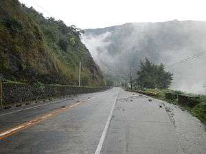 The highway in Tuba | ||||
| Route information | ||||
| Length | 47.2 km (29.3 mi) | |||
| Component highways | ||||
| Major junctions | ||||
| East end |
| |||
|
| ||||
| West end |
| |||
| Location | ||||
| Major cities | Baguio | |||
| Towns | ||||
| Highway system | ||||
|
Roads in the Philippines
| ||||
.svg.png)
Aspiras–Palispis Highway (also known as Marcos Highway and the Agoo–Baguio Road) is a Philippine major highway in northern Luzon that runs from the city of Baguio to the municipality of Agoo in the province of La Union.
The 47.17-kilometre (29.31 mi)[1] highway traverses the municipality of Tuba in Benguet, and the municipalities of Pugo, Tubao, and Agoo in La Union.
It is one of the three main roads used by motorists and travelers to access Baguio from the lowlands.[2] The highway's several rehabilitation and development efforts[3] led to the road's categorization as an "all-weather road",[4] and is the preferred highway by motorists to use over the older Kennon Road.[5]
The entire highway is designated as the National Route 208 (N208) of the Philippine highway network.
History
Marcos Highway was renamed into Aspiras–Palispis Highway on October 31, 2000 with the issuance of Republic Act 8971.[6] The highway section covering Baguio City and Benguet province was designated as the Ben Palispis Highway in honor of former Benguet Governor Ben Palispis. The La Union section of Marcos Highway was named Jose D. Aspiras Highway after Filipino politician Jose D. Aspiras.[5][6] However, the former name is considered by people to be more familiar and is still preferred by most.[7]
The Palina Bridge, situated along the Benguet-La Union provincial border, serves as the boundary between the two highways.[8]
Intersections
| Region | Province | City/Municipality | km | mi | Destinations | Notes | |
|---|---|---|---|---|---|---|---|
| Ilocos Region | La Union | Agoo | 236.115 | 146.715 | Western terminus. | ||
| Cases Boulevard | |||||||
| Macalva Barangay Road | |||||||
| Tubao | Aspiras Street | ||||||
| Nilangoyan - Tubao Road | |||||||
| 244 | 152 | Tavora Street | |||||
| Pugo | |||||||
| Cares Bridge (over Pugo River) | |||||||
| Ilocos Region - Cordillera Administrative Region boundary | La Union - Benguet boundary | Pugo - Tuba boundary | 259.267– 259.314 | 161.101– 161.130 | La Union 2nd - Benguet 1st highway boundary | ||
| Cordillera Administrative Region | Benguet | Tuba | 259.314 | 161.130 | No major junctions | ||
| 276 | 171 | Badiwan tunnel | |||||
| 277 | 172 | Badiwan Bridge | |||||
| Tuba - Baguio boundary | 279.145– 279.149 | 173.453– 173.455 | Benguet 1st - Baguio highway boundary | ||||
| Baguio | 280.702 | 174.420 | |||||
| Bakakeng Road | |||||||
| 282 | 175 | Legarda Road | |||||
| 283.454 | 176.130 | Baguio General Hospital Circle. Eastern terminus. Road continues north as Governor Pack Road. | |||||
| 1.000 mi = 1.609 km; 1.000 km = 0.621 mi | |||||||
Notable landmarks
The 519-metre (1,703 ft) long Badiwan Viaduct, constructed in 2001, serves as a major bridge along Badiwan, Barangay Poblacion in Tuba, Benguet.[9][10] Several meters from it is a concrete tunnel to protect motorists from landslides.[5]
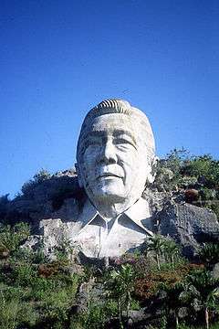
The blasted remains of the Marcos Bust,[11] a giant concrete head sculpture of the former Philippine President Ferdinand Marcos can be seen along the highway at Barangay Palina, in Pugo, La Union.[12] [13]
See also
References
- ↑ "Operation, Maintenance, Improvement of Kennon Road and Marcos Highway". Department of Public Works and Highways (Philippines). 25 Aug 2014. Retrieved 29 September 2014.
- ↑ "Reason No. 46 - Baguio City: How to Get There". League of Cities of the Philippines. Retrieved 29 September 2014.
- ↑ Zambrano, Joseph (7 April 2013). "Gov't releases P20 M for highway rehab". Baguio Midland Courier. Retrieved 29 September 2014.
- ↑ "Kennon or Marcos?". GoBaguio!. Retrieved 29 September 2014.
- 1 2 3 "Aspiras-Palispis-Marcos Highway". Libotero. 27 October 2010. Retrieved 29 September 2014.
- 1 2 "An Act Naming the Agoo-Tubao-Pugo Section of the Agoo-Baguio Road, the Jose D. Aspiras Highway, and the Benguet-Baguio City Section of the Same Road, the Ben Palispis Highway". Chan Robles Virtual Law Library. Retrieved 29 September 2014.
- ↑ Opiña, Rimaliza (26 July 2010). "Councilor stressed correct name of road". Sun.Star Baguio. Archived from the original on 31 July 2010. Retrieved 29 September 2014.
- ↑ "Ben Palispis Hway". Mapcentral. Retrieved 29 September 2014.
- ↑ Alambra, Aurora (29 December 2001). "Arroyo inaugurates Benguet viaduct". The Philippine Star. Retrieved 29 September 2014.
- ↑ "Barangay Poblacion". Municipality of Tuba, Benguet (official website). Retrieved 29 September 2014.
- ↑ "Baguio's Three Major Access Roads". City of Pines. Retrieved 29 September 2014.
- ↑ Dumlao, Artemio (30 December 2002). "Marcos bust blasted". The Philippine Star. Retrieved 29 September 2014.
- ↑ "La Union: Points of Interest". Tripod (La Union). Retrieved 29 September 2014.
Coordinates: 16°22′43″N 120°32′29″E / 16.3786°N 120.5414°E