Aserdaten, New Jersey
| Aserdaten, New Jersey | |
|---|---|
| Unincorporated community | |
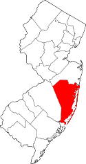
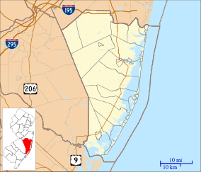 Aserdaten, New Jersey Location within Ocean County. Inset: Location of Ocean County in the state of New Jersey  Aserdaten, New Jersey Aserdaten, New Jersey (New Jersey)  Aserdaten, New Jersey Aserdaten, New Jersey (the US) | |
| Coordinates: 39°51′23″N 74°20′17″W / 39.85639°N 74.33806°WCoordinates: 39°51′23″N 74°20′17″W / 39.85639°N 74.33806°W | |
| Country |
|
| State |
|
| County | Ocean |
| Township | Lacey |
| Elevation[1] | 45 ft (14 m) |
| Time zone | UTC-5 (Eastern (EST)) |
| • Summer (DST) | UTC-4 (EDT) |
| GNIS feature ID | 882943[1] |
Aserdaten is an unincorporated community and ghost town located within Lacey Township in Ocean County, New Jersey, United States.[1][2]
The former community is located within the Greenwood Forest Wildlife Management Area, surrounded by the densely forested Pine Barrens.[3]
In 1893, Aserdaten was noted by the United States Geological Survey as a "village in Lacey Township".[4]
A forest fire watch tower—the Cedar Bridge Lookout Tower—was located in "the remote area of Aserdaten" until 1983.[5]
References
- 1 2 3 U.S. Geological Survey Geographic Names Information System: Aserdaten (historical)
- ↑ Locality Search Archived 2016-07-09 at the Wayback Machine., State of New Jersey. Accessed November 28, 2014.
- ↑ "Greenwood Forest Wildlife Management Area". New York–New Jersey Trail Conference. Retrieved November 28, 2014.
- ↑ Bulletin of the United States Geological Survey, Issues 112-121. United States Government Printing Office. 1893. p. 13.
- ↑ Section Forest Firewardens of Division B (2006). New Jersey Forest Fire Service. Arcadia Publishing. p. 34.
This article is issued from
Wikipedia.
The text is licensed under Creative Commons - Attribution - Sharealike.
Additional terms may apply for the media files.