Angles-sur-l'Anglin
| Angles-sur-l'Anglin | ||
|---|---|---|
| Commune | ||
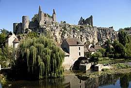 Castle ruins | ||
| ||
 Angles-sur-l'Anglin Location within Nouvelle-Aquitaine region  Angles-sur-l'Anglin | ||
| Coordinates: 46°41′46″N 0°53′08″E / 46.6961°N 0.8856°ECoordinates: 46°41′46″N 0°53′08″E / 46.6961°N 0.8856°E | ||
| Country | France | |
| Region | Nouvelle-Aquitaine | |
| Department | Vienne | |
| Arrondissement | Montmorillon | |
| Canton | Montmorillon | |
| Intercommunality | Pays châtelleraudais | |
| Government | ||
| • Mayor (2014-2020) | Jean-François Lecamp | |
| Area1 | 14.75 km2 (5.70 sq mi) | |
| Population (2014)2 | 384 | |
| • Density | 26/km2 (67/sq mi) | |
| Time zone | UTC+1 (CET) | |
| • Summer (DST) | UTC+2 (CEST) | |
| INSEE/Postal code | 86004 /86260 | |
| Elevation |
63–139 m (207–456 ft) (avg. 93 m or 305 ft) | |
|
1 French Land Register data, which excludes lakes, ponds, glaciers > 1 km2 (0.386 sq mi or 247 acres) and river estuaries. 2 Population without double counting: residents of multiple communes (e.g., students and military personnel) only counted once. | ||

Angles-sur-l'Anglin is a commune in the Vienne department in the Nouvelle-Aquitaine region in western France. It has been selected as one of the most beautiful villages of France.
The Château d'Angles-sur-l'Anglin is a ruined castle dating back to the 11th century, originally constructed for the Bishop of Poitiers.
Geography
See also
References
| Wikimedia Commons has media related to Angles-sur-l'Anglin. |
This article is issued from
Wikipedia.
The text is licensed under Creative Commons - Attribution - Sharealike.
Additional terms may apply for the media files.