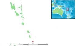
Aneityum
| Anejom̃ | |
|---|---|
 Location | |
| Geography | |
| Coordinates | 20°12′S 169°49′E / 20.200°S 169.817°E |
| Area | 159.2 km2 (61.5 sq mi) |
| Highest elevation | 852 m (2,795 ft) |
| Highest point | Mount Inrerow Atamein |
| Administration | |
| Demographics | |
| Population | 915 (2009) |
Aneityum (also known as Anatom or Keamu) is the southernmost island of Vanuatu, in the province of Tafea.[1]
Geography
Aneityum is the southernmost island of Vanuatu (not counting the Matthew and Hunter Islands, which are disputed with New Caledonia, but considered by the people of Aneityum Island part of their custom ownership).
Its southeastern cape Nétchan Néganneaing is the southernmost point of land in Vanuatu, more southerly than the southern satellite islet Inyeug. The latter, however, is surrounded by Intao Reef, that extends even further south, albeit submerged, thus being the southernmost feature of Vanuatu.
The island is 159.2 km2 (61.5 sq mi) in size. It rises to an elevation of 852 m (2,795 feet) in Mount Inrerow Atamein.
The larger of its two villages is Anelcauhat (AKA Anelghowhat), on the south side.
Population
Aneityum had a population of 915 in 2009.[2] This population is believed to have been possibly more than 12,000 prior to the arrival of the Europeans, in 1793. However, introduced diseases and blackbirding played a major role in Aneityum's massive depopulation, which left the island with less than 200 inhabitants in 1930.
The main language of Aneityum island is also called Aneityum, or Anejom̃ in the local orthography.
Traditional Chiefdoms
At the time of first contact with Europeans (around 1830) the island was subdivided into seven chiefdoms (nelcau) that each were presided by a natimarid (high chief) (clockwise, starting in Northwest:):
- Anau-Unse (Annaunse)
- Ijipdav (Epege)
- Anetcho (Aneitio)
- Anau-Unjai (Aname)
- Anumej-Anekro (Annuantchai)
- Umej (Umetch)
- Anelcauhat
The chiefdoms were further subdivided into more than 50 districts that were presided by minor chiefs (natimi alupas). The power of the chiefs was mainly of ritual nature.[3]
Maps
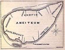 Map of 1882
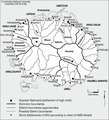 Map of the traditional chiefdoms and districts
Transportation
The island is served by Anatom Airport, not on the main island itself, but on the tiny island to its south, Iñec (or Inyeug, also known as "Mystery Island"), across the main village, which has three weekly flights from Port Vila via Tanna.
References
- ↑ "Mystery Island Cruise & Aneityum Island". Vanuatu Travel. Retrieved 13 August 2018.
- ↑ 2009 Census Summary release final Archived 2013-12-21 at the Wayback Machine. - Government of Vanuatu
- ↑ Matthew Spriggs: Population in a Vegetable Kingdom. Aneityum Island (Vanuatu) at European Contact in 1830. Kapitel 14 in Patrick V. Kirch und Jean-Louis Rallou (Hrsg.): The Growth and Collapse of Pacific Island Societies. Archaeological and Demographic Perspectives. University of Hawai‘i Press, Honolulu 2007, S. 278–305.
External links
