Al-Mazra'a al-Qibliya
| Al-Mazra'a al-Qibliya | |
|---|---|
| Other transcription(s) | |
| • Arabic | المزرعه القبليّه |
 Al-Mazra'a al-Qibliya | |
 Al-Mazra'a al-Qibliya Location of Al-Mazra'a al-Qibliya within Palestine | |
| Coordinates: 31°57′00″N 35°09′06″E / 31.95000°N 35.15167°ECoordinates: 31°57′00″N 35°09′06″E / 31.95000°N 35.15167°E | |
| Palestine grid | 164/151 |
| Governorate | Ramallah & al-Bireh |
| Government | |
| • Type | Municipality |
| • Head of Municipality | Abdullah Ladadwa |
| Area | |
| • Jurisdiction | 15,500 dunams (15.5 km2 or 6.0 sq mi) |
| Population (2013) | |
| • Jurisdiction | 8,105 |
| Name meaning | Mezeirat el Kibliyeh; the southern sown land[1] |
| Website | www.alzeitona-mun.org |
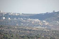
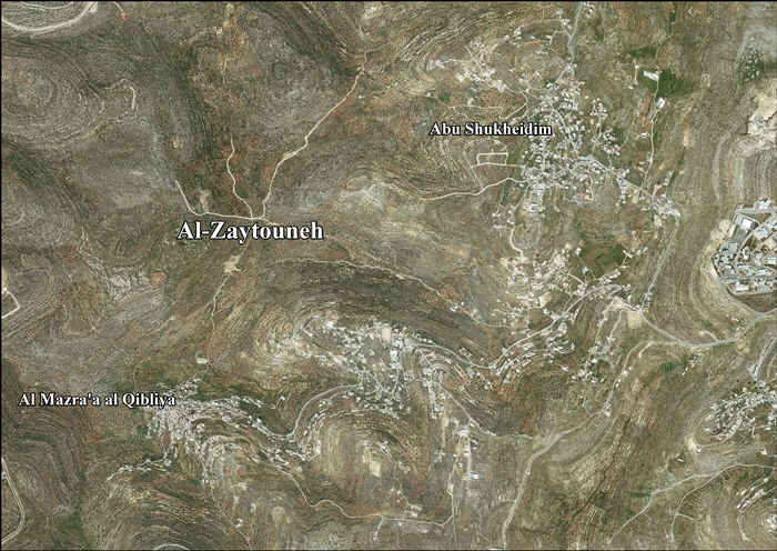
Al-Mazra'a al-Qibliya was a Palestinian village in the Ramallah and al-Bireh Governorate.
In 2005 it merged with the village of Abu Shukheidim to form the town of Al-Zaitounah.
History
Pottery sherds from the Byzantine era have been found here.[2]
Ottoman era
The village was incorporated into the Ottoman Empire in 1517 with all of Palestine, and in 1596 it appeared in the Ottoman tax registers as Qibliyya, being in the nahiya (subdistrict) of Quds, part of the liwa (district) of Quds. It had a population of 8 households, all Muslims. The villagers paid a fixed tax rate of 33.3% on various agricultural products, including wheat, barley, summer crops, olive trees, goats and/or beehives, in addition to "occasional revenues"; a total of 2,190 Akçe.[3] Pottery sherds from the early Ottoman era have also been found here.[2]
In 1838, it was noted as a Muslim village, el-Mezra'ah, in the Bani Harith district, north of Jerusalem.[4]
An Ottoman village list of about 1870 showed that Mezra'a had 111 houses and a population of 428, though the population count included men, only.[5][6]
In 1882, the Palestine Exploration Fund's Survey of Western Palestine described Mezeirat el Kibliyeh as: "a good sized village on low ground, among olives".[7]
In 1896 the population of 'Mezraa in Bani Harit was estimated to be about 1,569 persons.[8]
British Mandate
In the 1922 census of Palestine, conducted by the British Mandate of Palestine, there were 492 people living in Al Mizra'a al-Qibliyeh, all Muslims,[9] rising to 799 Muslims in the 1931 census, in a total of 162 houses.[10]
In 1945 statistics the population was 860, all Muslims,[11] while the total land area was 13,240 dunams, according to an official land and population survey.[12] Of this, 6,483 were plantations and irrigable land, 1,847 for cereals,[13] while 34 dunams were classified as built-up areas.[14]
Jordanian era
In the wake of the 1948 Arab–Israeli War, and after the 1949 Armistice Agreements, Al-Mazra'a al-Qibliya came under Jordanian rule.
The Jordanian census of 1961 found 1,349 inhabitants.[15]
Post-1967
After the Six-Day War in 1967, Al-Mazra'a al-Qibliya has been under Israeli occupation.
After the 1995 accords, 54.2% of Al-Zaitounah land was defined as Area B, while the remaining 45.8% was defined as Area C. Israel has confiscated 308 dunams of land from Al-Zaitounah in order to construct two Israeli settlements, Talmon and Nahl'iel.[16]
References
- ↑ Palmer, 1881, p. 239
- 1 2 Finkelstein et al, 1997, p.392
- ↑ Hütteroth and Abdulfattah, 1977, p. 112
- ↑ Robinson and Smith, 1841, vol 3, 2nd appendix, p. 124
- ↑ Socin, 1879, p. 158 It was also noted to be in the Beni Harit district
- ↑ Hartmann, 1883, p. 126, noted 112 houses
- ↑ Conder and Kitchener, 1882, SWP II, p. 294
- ↑ Schick, 1896, p. 122
- ↑ Barron, 1923, Table VII, Sub-district of Ramallah, p. 17
- ↑ Mills, 1932, p. 50.
- ↑ Government of Palestine, Department of Statistics, 1945, p. 26
- ↑ Government of Palestine, Department of Statistics. Village Statistics, April, 1945. Quoted in Hadawi, 1970, p. 65
- ↑ Government of Palestine, Department of Statistics. Village Statistics, April, 1945. Quoted in Hadawi, 1970, p. 112
- ↑ Government of Palestine, Department of Statistics. Village Statistics, April, 1945. Quoted in Hadawi, 1970, p. 162
- ↑ Government of Jordan, 1964, p. 24
- ↑ AL-Zaytouneh Town Profile, ARIJ, p. 18
Bibliography
- Barron, J. B., ed. (1923). Palestine: Report and General Abstracts of the Census of 1922. Government of Palestine.
- Conder, C.R.; Kitchener, H.H. (1882). The Survey of Western Palestine: Memoirs of the Topography, Orography, Hydrography, and Archaeology. 2. London: Committee of the Palestine Exploration Fund.
- Finkelstein, I.; Lederman, Zvi, eds. (1997). Highlands of many cultures. Tel Aviv: Institute of Archaeology of Tel Aviv University Publications Section. ISBN 965-440-007-3.
- Government of Jordan, Department of Statistics (1964). First Census of Population and Housing. Volume I: Final Tables; General Characteristics of the Population (PDF).
- Government of Palestine, Department of Statistics (1945). Village Statistics, April, 1945.
- Hadawi, S. (1970). Village Statistics of 1945: A Classification of Land and Area ownership in Palestine. Palestine Liberation Organization Research Center.
- Hartmann, M. (1883). "Die Ortschaftenliste des Liwa Jerusalem in dem türkischen Staatskalender für Syrien auf das Jahr 1288 der Flucht (1871)". Zeitschrift des Deutschen Palästina-Vereins. 6: 102–149.
- Hütteroth, Wolf-Dieter; Abdulfattah, Kamal (1977). Historical Geography of Palestine, Transjordan and Southern Syria in the Late 16th Century. Erlanger Geographische Arbeiten, Sonderband 5. Erlangen, Germany: Vorstand der Fränkischen Geographischen Gesellschaft. ISBN 3-920405-41-2.
- Mills, E., ed. (1932). Census of Palestine 1931. Population of Villages, Towns and Administrative Areas. Jerusalem: Government of Palestine.
- Palmer, E. H. (1881). The Survey of Western Palestine: Arabic and English Name Lists Collected During the Survey by Lieutenants Conder and Kitchener, R. E. Transliterated and Explained by E.H. Palmer. Committee of the Palestine Exploration Fund.
- Robinson, E.; Smith, E. (1841). Biblical Researches in Palestine, Mount Sinai and Arabia Petraea: A Journal of Travels in the year 1838. 3. Boston: Crocker & Brewster.
- Schick, C. (1896). "Zur Einwohnerzahl des Bezirks Jerusalem". Zeitschrift des Deutschen Palästina-Vereins. 19: 120–127.
- Socin, A. (1879). "Alphabetisches Verzeichniss von Ortschaften des Paschalik Jerusalem". Zeitschrift des Deutschen Palästina-Vereins. 2: 135–163.
External links
- Welcome to al-Mazra'a al-Qibliya
- Survey of Western Palestine, Map 14: IAA, Wikimedia commons
- AL-Zaytouneh town (fact sheet), Applied Research Institute–Jerusalem (ARIJ)
- AL-Zaytouneh town profile, (ARIJ)
- AL-Zaytouneh aerial photo, (ARIJ)
- Locality Development Priorities and Needs in AL- Zaytouneh Town, (ARIJ)
