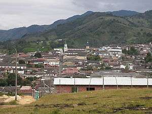
Abejorral
| Abejorral | |||
|---|---|---|---|
| Municipality and town | |||
 | |||
| |||
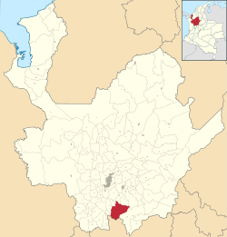 Location of the municipality of Abejorral in the Antioquia Department | |||
 Abejorral Location in Colombia | |||
| Coordinates: 5°47′22″N 75°25′41″W / 5.78944°N 75.42806°WCoordinates: 5°47′22″N 75°25′41″W / 5.78944°N 75.42806°W | |||
| Country |
| ||
| Region | Andean Region | ||
| Department |
| ||
| Subregion | Eastern | ||
| Elevation | 2,275 m (7,464 ft) | ||
| Website | http://www.abejorral-antioquia.gov.co/ | ||


Abejorral is a town and municipality in Antioquia Department, Colombia. Part of the subregion of Eastern Antioquia.[1] It borders to the north with the municipalities of Montebello, La Ceja and La Unión, to the east with municipality of Sonsón, to the south with the department of Caldas and to the west with the municipalities of Santa Bárbara y Montebello.
It was founded in 1805 by José Antonio Villegas, although some believe it was in 1811.[2] The latter was the year when the titles of the land were officially donated to the then existing residents.[2]
Sites of interest
Most of the town is a historical site; the architecture that has survived through the years gives Abejorral the aspect of a city "suspended" in the colonial era, which is the reason that a part of the municipality was declared National monument. Sites of interest include[1]:
- Nuestra Señora del Carmen parish church.
- Nuestra Señora de los Dolores chapel.
- Hospital chapel.
- Municipal Cemetery.
- The Ancient Presbytery (Antigua Casa Cural).
- The founder’s house (Casa del fundador).
- The Orange House (La Casa Naranjada).
References
- 1 2 "Alcaldia Municipal de Abejorral" (in Spanish). Retrieved 2018-06-09.
- 1 2 "Abejorral : generalidades" (in Spanish). 2009-07-29.
| Wikimedia Commons has media related to Abejorral. |
Capital: Medellín | |||||||||||||||||||
| Regions and municipalities |
| ||||||||||||||||||
| Related topics | |||||||||||||||||||